
MIBS #1, all about me
I’m a little hazy about my Miami International Boat Show history — twelve in a row, I think — but I’m pretty sure this has been the best yet. One highlight was planing a...
The Marine Electronics Hub

I’m a little hazy about my Miami International Boat Show history — twelve in a row, I think — but I’m pretty sure this has been the best yet. One highlight was planing a...
I wrote about Standard Horizon’s new CPN series in December — and in the current issue of Cruising World — but now there’s more detail up on the SH web site. I particularly like the...
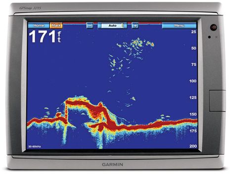
So now a CHIRP war is breaking out. This morning Garmin announced two new black box fishfinders: The GSD 24 appears to be a $700 redesign of its previous top-of-the-line digital box while the $2,000 GSD 26 is an obvious play for the truly serious fishing crowd. The GSD 26 features “Spread Spectrum” technology, which seems to be another name for the CHIRP support that Simrad announced as part of its new BSM-2 box in September. In fact, both Garmin and Simrad will be running demos of their advanced fishfinding over the next couple of days off Miami, and I’ll be taking a ride with each…
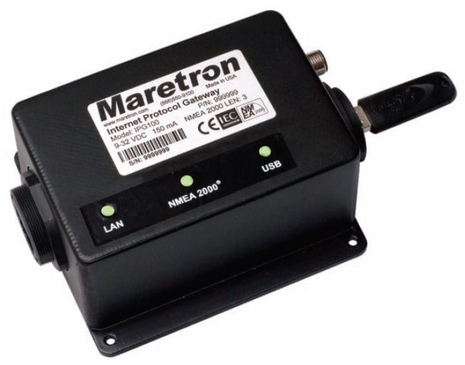
Wow, Maretron just released the IPG100, an “Internet Protocol Gateway” that can take all the NMEA 2000 PGNs on a backbone, turn them into TCP/IP data packets, and serve them out an Ethernet port. Which means of course that the data can then be routed by cable to a vessel’s local network of computers (and other fixed Ethernet gear) and by WiFi to an infinite assortment of onboard mobile tablets, apps phones, etc. Obvious too is that an IP gateway could also be adept at sending data off a vessel, and vice versa, for remote monitoring, troubleshooting, and more. And Maretron’s IPG100 consumes only 0.5 amps of N2K backbone power at most and its $595 price tag includes much more than I’ve already described. Or much less, depending on your point of view!…
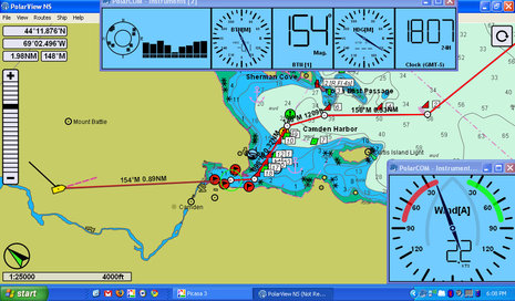
I took a peek at PolarView NS charting software about a year ago, but didn’t write about it because I wasn’t especially impressed (and there’s a certain randomness to what I cover anyway). But times change and software develops, and I’m here to tell you that PolarView 1.5 (video introduction here) is pretty darn impressive. Given its app-like $40 price tag, it’s a remarkably powerful program that runs on Windows, Mac OS X, and Linux operating systems. The screen above shows PV running on my little ASUS Eee PC 1000HE 10-Inch netbook
with live NMEA 0183 data coming from the lab’s N2K network via a Maretron USB 100. PolarView is quite unusual in that it uses a sister program, called PolarCOM, to do all its data interfacing and instrument displays…
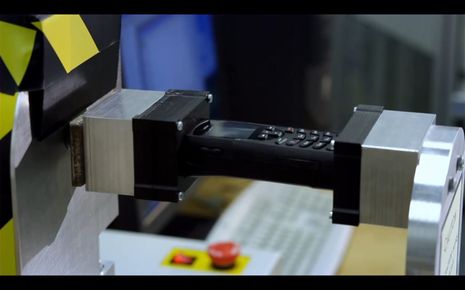
That diabolical test machine is forcing a measured, if destructive, twist into an Iridium 9555 sat phone, which may be a good metaphor for what Inmarsat had in mind when it commissioned an independent study comparing its Isatphone Pro to the 9555 as well as the Thuraya XT (which doesn’t cover the Americas). After all, there had already been crowing about another “independent study” that turned out to be commissioned by Iridium (downloadable here). Now it’s very easy to be cynical about studies that each find the hardware and service offered by the company that paid to be superior, but actually I found both reports to be largely credible and quite useful…
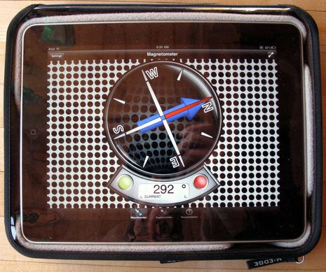
I find that my iPad is so sharp and slippery that I almost always use it in a case, and once I get it on the boat there will also be an increased danger of impact or water damage. So I’ve been testing three candidates for Gizmo’s cruising iPad case. That M-Edge Leisure Jacket above is far and away my favorite at this point. Yes, it’s a bit bulky but the high-density fitted-foam bed and cloth cover are light, easy to handle, and highly protective; and the whole thing tends to stay where you put it. Perhaps most important, the vinyl cover does not impede screen use nearly as much as you might presume. I’ve used the Jacket a lot now, with all kinds of apps, and I’m rarely annoyed by the plastic. The pocket on the back may be too tight to be very useful — and I wish it had a “kickstand” for typing comfort (though it’s easy to stick something under there to get the right tilt) — but I like the Leisure Jacket. Now, about that weird compass app…
Panbo reader Laurence Woodward built his own 40′ catamaran in Devon, England, and he’d like to use Garmin GMI 10 color N2K instrument displays at both helms. However, his mast rotates and therefore he needs some sort of sensor to keep track of that rotation, which must then be applied to the apparent wind data coming from his masthead vane (or ultrasonic). I doubt that Garmin will develop its own rotation sensor because there aren’t that many rotating masts out there, but then again maybe just a software tweak to their existing rudder angle adaptor might be all it takes. Or perhaps there’s another way? Let’s discuss…
Yet another blizzard is descending on Panbo HQ, and that’s excuse enough to further indulge my obsession with local charting, specifically the issue mentioned on Monday about how Northeast Point became an island. It...
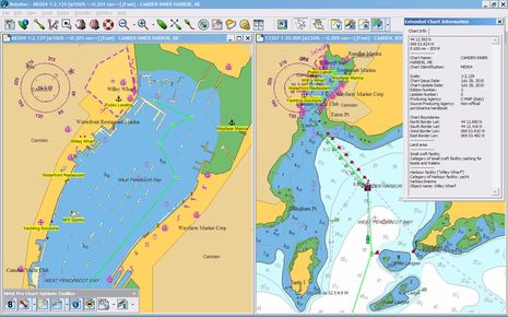
Testing Nobeltec Admiral 11 is going pretty well, and I’ll write about it soon, but what really got me grinning is the latest C-Map Max Pro chart of Camden Harbor that came along with the trial software. I’m a long time fan of C-Map’s C-Marina concept — in which cooperating marinas are charted in super high resolution — but in actuality C-Map’s earlier attempts at Wayfarer Marine detail were seriously flawed. Well, not only is Wayfarer now exceptionally well depicted (with one major exception), but other improvements make C-Map’s the best visual guide to my harbor’s complexities yet created, I think. Please click on the image above for a full screen window as I explain…


