
Problem with COG/SOG smoothing on Garmin handhelds?
It’s often hard to get big companies to change or fix arguably minor product issues, and I’m pretty sure the best path to success is to clearly, politely, and persistently state the facts, maybe even illustrate the problem on YouTube. But that doesn’t necessarily work either, which is why I’m publishing this email from bluewater sailor Bruce Balan in full:
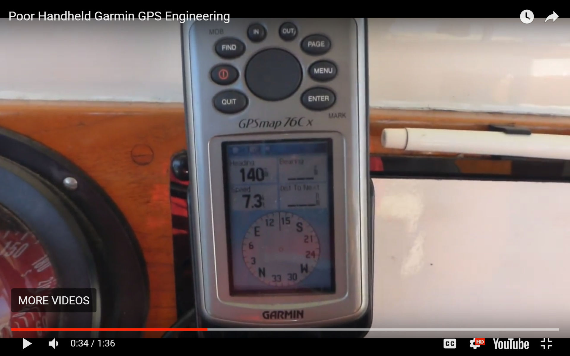
I’ve been exchanging emails with Garmin for years over their lack of COG and SOG smoothing in their handheld GPS. I know it is low-tech compared to a lot of equipment you report on, but we find using a handheld as our primary nav aid in the cockpit very useful; it keeps our eyes looking out and not on a screen. (Though we do use a tablet to help out in tight quarters.) This has worked well for us for the last 54,000 NM. There is also the very important benefit to a cruising sailboat of low power requirements.
Unfortunately, as GPSs have become more accurate, the otherwise well-designed Garmin handhelds have become almost useless in most conditions found at sea. The SOG and COG are affected so much by even a small swell, that you never know your exact course or speed. You can see an example here: https://youtu.be/hZPCZ4jyzAg
I’ve practically begged Garmin to fix the problem but to no avail. It’s too bad because much of the rest of their design is excellent (except maybe that the anchor alarm’s first entered digit is at 1,000 feet!).
I thought your readers may want to be aware of this issue if they are considering a handheld for cruising.
Solid experience should also count with manufacturers, I think, and did you catch the “last 54,000 NM” reference? Wow. Bruce’s email included a Shiptrak tracking link, and down below is the path of his Cross 46 trimaran Migration in just the last year, which was only the last leg in what looks like an amazing 12 year meander around the Pacific (brucebalan.com/migrations). If Bruce and his partner Alene gave their cruising presentation somewhere reasonably nearby, I’d go.
Now back to the subject at hand. Have any readers experienced the handheld COG/SOG jumpiness that’s bothered Bruce for so many sea miles?
PS 4/2: I didn’t realize how controversial this post would be, and I’d like to clarify some points. For one thing, Bruce’s GPSMAP 76Cx was sold as a “mariner-friendly” handheld GPS (though now discontinued), and for another he’s not complaining about its accuracy (or trying to get it to steer his autopilot).
What Bruce is calling a problem and I phrased as an “arguably minor product issue” is how well the 76 can “smooth” its Course and Speed Over Ground calculations. Also called averaging, filtering, or damping, this used to be a commonly discussed marine GPS issue (try this search). I believe that every GPS does this to some degree and that there is no absolutely correct way it’s done.
Calculating course and speed by comparing somewhat inaccurate positions over very short time periods on a vessel that may also be rolling, pitching, and heaving is not easy, especially if the boat is moving slowly over the ground. COG in particular was often a very jumpy value in the early days of marine GPS. Then manufacturers gave users some control over how much to smooth the readings and now they usually do a nice job of it automatically and dynamically, by which I mean you want different smoothing as a boat speeds up and maneuvers.
In fact, I think that Garmin marine displays have gotten particularly good at presenting steady, sensible COG and SOG numbers, even reasonably valid COG sometimes when the boat was tied up at a dock (though I’d prefer stopped to show no COG, and that their icons become circles unless valid Heading is available). At any rate, is Bruce really so wrong to want better COG/SOG smoothing on a fairly recent a high-quality marine handheld GPS?
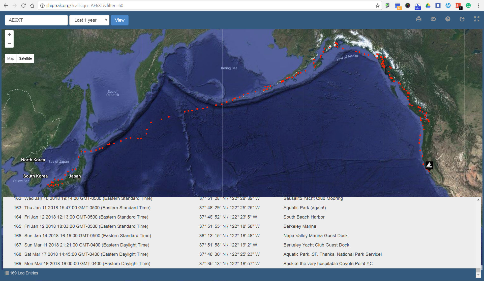


Off topic, I know, but I’m probably not the only one curious about how Shiptrak works:
http://www.mmsn.org/tools/sailor-services.html
Cruisers can use various, often inexpensive ways to post real-time positions and short texts into the Winlink 2000 or Yotreps databases, which then display on Shiptrak. Bruce told me that he used to post via Winlink using Airmail software and a PTC modem with his Icom 706, but switched to Airmail with Iridium Go for the North Pacific crossing.
I don’t want to seem like I’m supporting Garmin in terms of a product which ‘isn’t working’ as 1 user feels it should, BUT, is this a situation where this isn’t the right tool for the job?
Was the GPSmap76Cx designed for inland lakes or crossing the Pacific?
Seemed to me that this is akin to having a Philips head screw and only a flat bladed screw driver. Can you make that work, maybe, but you’d be better off with the right tool.
I must admit, if I were going to take a 54K trip I would want more robust, integrated equipment.
What does Bruce use for autopilot and radar display as well as AIS? All tools I’d want on that type of trip.
This is just my 2cents.
Safe travels.
Charles, the GPSmap76Cx even supports marine charts and is used by many delivery skippers at least as a backup because it is so robust (and independent).
https://buy.garmin.com/en-US/US/p/350
And if the unit is overly sensitive to boat motion on a 46-foot trimaran in fairly calm conditions (see video), wouldn’t that also be true on a smaller boat?
I don’t know what other nav equipment Bruce uses — maybe he’ll tell us — but let’s acknowledge that he’s not going to take a 54nm trip; he’s already done that, and is apparently going back out into the Pacific again next year. I’d probably install so many electronics the boat would lose a knot, but I do recall how amazingly functional and accurate a handheld GPS seemed back in the
1980’searly 1990’s during coastal and offshore deliveries.According to an article I just found on the history of GPS the first handheld was on the market in 1989. (Magellan NAV 1000). My fist one was a Garmin 2. And it got us from Falmouth Maine to Yarmouth NS quite a few times. Connected to a laptop with a charting program. Since then I have had 3 different ones including the one shown above. When I was in the USCG from 1976 to 1980 we only had a loan from a helicopter on a 378 (the Dallas) It didn’t do very well when far from land stations.
Thanks, Ted…I’m not great with dates. I did sail with the Magellan white brick a few times, but the first GPS I owned was the Garmin 45, starting some time in the early 90’s (I think).
I have vivid memories of entering New York Harbor one very, very foggy spring morning on a slightly beat sailboat including the nervous new owners. We never actually saw a navaid, a vessel, or any land until we were directly under the Verrazano Narrows Bridge, which we could only see directly overhead.
Plotted and doublechecked waypoints entered into the Garmin 45, a depth sounder, and a handheld VHF were the key tools. It was a memorable experience that probably partially motivated my later career.
No problem, I can remember using my first one and how great it was compared to just DR. I had a route in it around the islands in Muscungus Bay. Once I made it I was able to get to each of 5 islands in the fog with no problem. Compared
to what they can do today it’s amazing.
I would have to say it is working as I would want it to. I have a 18 foot lund on the coast of Maine and raced on large sailboats. On the sailboats we would have speed to .00 so we could see the change as fast as possible so we could react. For direction I can tell if the change is due to a swell or the boat moving enough that I need to react. Same is true with a mag compass. You can’t be chasing either.
Ben – the review and video are less than thorough and borders on whining. There was no reference to other instruments that may indicate a similar/dissimilar data. There’s no reference to what’s driving the vessel – either autopilot, individual. Nothing is noted on the engine size/type, which could impact speed fluctuations.
You can do better than posting inflammatory articles like this. To continue being a great resource for your readers, please do a little homework as you have in the past.
Ouch! But I think my mistake was not explaining the inherent issues with derived COG and SOG from GPS. Modern marine fixed displays tend to show quite steady COG/SOG values, but that’s because a lot of dynamic data dampening is happening behind the scenes. The jumpy behavior Bruce is complaining about and showing on his video are familiar to me because I used to see it a lot.
I will add a PS to the entry later, but right now we’re calling it Spring in Maine. Mid forties, sunny, dry, and just some snow patches left.
I normally never jump into the conversations, but working as a tech for a Garmin/Raymarine/Simrad/KVH/Maretron/Gost and many more dealer, I see this stuff occasionally and it drives me nuts. I gotta agree with Pete Shelquist on this one. Who cares. Everyone reading this blog knows Garmin makes excellent products and has good customer support. This person bought the wrong tool for the job. He went out and bought the cheapest thing he could find, and then expected it to perform a task it was never engineered to do. Did Garmin advertise it as having as fast refresh rate? Seems like he was expecting it to be as accurate as sensors for autopilot systems, guess what, those START at $800+. This was engineered for hikers. It has a low position refresh rate and probably a higher than average accuracy error. Its cheap! One second your over hear, five seconds later it thinks you’ve moved 30 feet to the left, uh oh, wild COG/SOG swing! Sadly this perpetuates the stereotype of sail boaters in this industry; ‘the wind is free and so should be everything else’.
If you’re going to keep it old school with your navigation, then do just that. Compass for heading, GPS to fix your position at your chosen time interval. Then, plot your position every so often on a chart, calculate your speed, set, drift, and VMG. If you want that done for you, then buy something that was designed, engineered, tested, and advertised and doing such.
On to the point of getting Garmin to fix the “problem”, I wonder if the new GPSMAP78c does this same thing? Maybe they did fix it………
Thanks T.I. I didn’t mean to trigger such passion with this entry but it’s good stuff to get out and discuss. Interestingly, just yesterday I watched an introduction to marine electronics video in which another passionate installer recommended having a handheld GPS on most every boat, including the 90-foot plus gold platers he’s worked on. He was demoing a Garmin 78sc…
https://buy.garmin.com/en-US/US/cOnTheWater-cHandhelds-p1.html
…which may well have improved COG/SOG smoothing, but his main point was about backup and reliability. (The video series is at https://www.offcenterharbor.com/ which requires at least a trial membership, but they offer lots of great boating films.)
Also, I just added a hopefully clarifying PS to the entry.
“have become almost useless in most conditions found at sea. The SOG and COG are affected so much by even a small swell, that you never know your exact course or speed.” This is not a fair comment and it makes me disinclined to believe him. I’ve got several Garmin handhelds, including this one, and the only complaint I have is that there is no new marine handheld model which supports GLONASS.
I think there is a solution to his problem (but it’s not one I care about, so I might be wrong) — Go into the track settings. There are options for how and how often to record track points. If you set it to “least often” I think you will find that the display is smoothed so much it’s actually sluggish.
Um, have we forgotten that cat’s & tri’s wobble quite a bit between the hulls as waves hit each hull at different points in time? If you had a marble on a near level table, the marble would do a circle each time a swell passed underneath at an odd angle to the hulls.
The amount of left/right motion in that wobble vs. the velocity forward is going to show up as a rather drastic change in COG.
For any gps that doesn’t have a multi axis sensor, not sure damping is even an option. The damping time would have to be pretty darn large, like the entire period of the swell passing under the hulls. If set that high, any real change is COG won’t show up for a long time.
As for SOG. In the video I observed the person holding the camera is swaying forward/back quite a bit with a fairly regular period. The GPS is going to be measuring that as a change in SOG. I would say the GPS is doing exactly what you should expect.
I guess I came out a little hot on my first comment. Hopefully I didn’t offend anyone, that wasn’t my intent,
These Garmin handhelds are a quality product and very reliable, I don’t think anyone here is disputing that. They should absolutely be carried as a backup, they are perfect for that. Exactly that, a backup. I stand by my initial assertion that this is the wrong tool for the job he was wanting done. Its not wrong for him to want excellent performance in the handheld, but this is a price point item. If I remember correctly this was literally the cheapest ‘marine’ product Garmin was selling at the time, please correct me if I’m wrong. You have to be realistic. As you have pointed out it takes a lot of decision making, programming, and computing to make smooth numbers show on the screen.
I think this ‘problem’ is a nothing burger. Its not a bait and switch situation, they didn’t rush a flawed product to market, it didn’t perpetually fail, in all honesty the customer just wanted it to do something better.
Could Garmin have done better? Sure they could have, and they did, just have to buy a higher end unit. If we want to talk specifically about handhelds, it looks as if Garmin took this persons complaints to heart, because they specifically address stable heading and other data in their advertisements of the new 78. Should they have gone back and wrote new software to update his and other older units? Maybe, maybe not. Did it meet all the engineering and performance specs that were decided upon at the beginning of design? Maybe there was a hardware limitation? Maybe the unit was operating perfectly as designed, and the budget at Garmin went to moving forward and bettering new products. Can you blame them?
I can see where you were wanting this discussion to go, to the intricacies of calculating dynamic data from fixed points, it is a cool topic, maybe this was just the wrong lead in for some people.
I asked Bruce Balan to comment on this conversation and, boy, did he. It’s way too much material for a regular comment box but I put it all together here:
http://panbo.com/wp-content/uploads/2018/04/Bruce-Balan-on-his-Garmin-handheld-GPS-COG-SOG-smoothing-issue.pdf
Important takeaways for me:
* Bruce says that he owned Garmin handheld GPS models before the 76Cx that did a better job of smoothing SOG and COG, and Garmin seemed to acknowledge that in their correspondance.
* Bruce makes an excellent case about why a portable GPS is a good nav tool for his particular use.
* As I suspected from the beginning, Bruce’s communications with Garmin were clearly and politely written, and persistent.
* As hoped, Garmin responded well to that sort of communication. They even offered a free swap for a small fixed marine GPS with better SOG/COG smoothing.
* It’s easy to conclude that Bruce is neither a cheapskate nor a whiner, and that Garmin is a decent company that makes excellent electronics. The mystery is why they apparently dropped a feature on their handheld GPS devices and have perhaps never restored it.
Hi Ben,
Thanks very much for taking the time to put the PDF together — and reading and digesting all that I wrote. I hope it answers some of the questions in the comments above… and maybe is read by Garmin also! Cheers, Bruce
My interactions with Garmin customer service have been “we haven’t ever heard about this” and emails into a black hole. Reading Bruce’s series of messages with a 3 year gap between question and answer is dismaying. The route function in Garmin handheld GPSes (“Marine” and not marine work the same) can be dangerous for cruisers (read ‘GPS for Mariners’) if the default “Auto” transition rule is used. A “distance” option was added to the software after GPS for Mariners came out but not mentioned in the user manuals. It’s there but semi-secret.