
The Class B AIS filtering myth revisited, arrrrrgh!
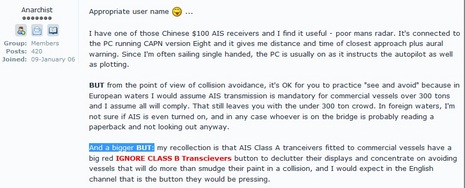
Click above for a readable image, and see how blithely an anonymous Sailing Anarchy poster spread AIS misinformation, reinforcing a myth that threatens to curtail adoption of Class B transponders. After first establishing himself as a sailor who uses an AIS receiver, he writes knowingly (but ignorantly) about specific AIS requirements around the world. And then comes the doozy: “My recollection is that AIS Class A transceivers fitted to commercial
vessels have a big red IGNORE CLASS B Transceivers button to declutter
their displays and concentrate on avoiding vessels that will do more
than smudge their paint in a collision“. That’s unadulterated BS on all counts — the big red button DOES NOT EXIST, the watch standers who don’t care about small vessels are rare, and this blowhard has probably never seen a ship’s bridge to “recollect” — but the myth continues to spread…
Yesterday I came across an even worse instance, because the source was a industry tech support person! Cruiser Glenn Tuttle recently moved up from an AIS receiver to a transponder, and was disappointed when several cruise ships he called around Panama couldn’t seem to see his vessel target a couple of miles away. (I don’t know what happened, but wonder if in fact they saw his dynamic target data but not the static data with his name, size, etc. — a known issue with older Class A transponders.) At any rate, Glenn researched the problem, as he reported on the Cruisers Network Online (which he happens to moderate):
I called Electronics Unlimited in Ft Lauderdale, Florida, where I purchased the unit and antenna. They just referred me to the tech support at Simrad. I finally was able to speak to a Simrad technician who told me “It is normal for Class A units not to be able to communicate with Class B units.” However, he continued to say “my Class B unit should be able to be seen by all Class B units”.
That misinformation makes me want to scream! Class A and Class B AIS are carefully designed to work together; they are an integrated System. The Class B transponders I’ve tried have been visible to almost every ship I asked (though sometimes not the static data). Yet Glenn understandably goes on to say, “Had I known this, I would have just replaced my old passive unit with another passive receive only unit and saved a bundle, or maybe bit the bullet and bought a Class A unit.”
My hope is that Glenn will soon have some positive Class B experiences, like being called by name while crossing a ship channel on a snotty night. My entry on that incident — which included the theory that this ships-ignoring-Class-B fear has become a “meme” — drew a lively response. I’d like to add a few points:
* First of all, let’s start describing this issue as “ignoring” Class B, because “filtering” is a vaguer term and hence confusing. For instance, a ship captain says he regularly filters Class B — just meaning he chooses not to show Class B target name text on his plotter — but a listener assumes that he’s ignoring Class B…and the myth spreads further.
* In fact, I now understand that Coastal Explorer’s option to not “Show Class B” — once called out here — does not mean they are ignored. Class B targets pop up again if CPA/TCPA alarm thresholds are crossed. And I believe that Fugawi removed the “Ignore Class B” option from its software completely. In that same thread, incidentally, a knowledgeable commenter claimed that new ship radars and ECDIS were mandated to offer the ability to ignore Class B, but it turned out that the rules being formulated — explained here — are quite the opposite, allowing targets of various sorts to be filtered but demanding that dangerous ones be shown.
* When you think about it, can you imagine that the IMO would allow anyone to ignore its carefully designed anti-collision system? Hell, no. As the good Kennebec Captain pointed out in yet another Panbo discussion on this subject, Rule 5 of the International Rules of the Road states that “Every vessel shall at all times maintain a proper lookout by
sight and hearing as well as by all available means appropriate in the
prevailing circumstances and conditions so as to make a full appraisal
of the situation and of the risk of collision” and those means certainly include AIS.
* To make the point stronger, can you imagine a Captain before a judge and jury trying to explain that he set his equipment to ignore Class B vessels, one of which he inadvertently ran over, because they cluttered his screen?
I think the truth here is pretty obvious. The big question is why does the myth grow that ships can and do ignore Class B transponders. Let’s discuss, and hopefully give Glenn Tuttle some confidence that he did the right thing by installing a Class B.
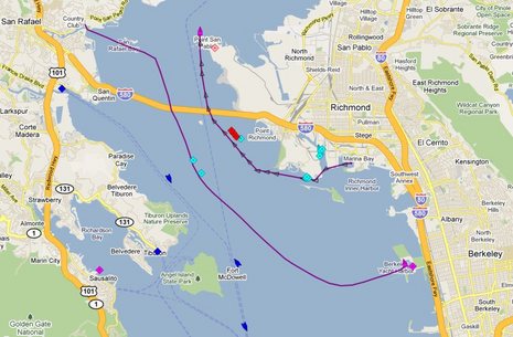
PS Concerning the Class B zig zag plotting worry discussed in the comments, here are the tracks of two Class B boats in San Francisco Bay this morning:


PS I have asked Simrad about the statement “It is normal for Class A units not to be able to communicate with Class B units” but haven’t heard back. It’s also possible that Glenn misunderstood the tech support person, I guess. Maybe he meant that it was fairly common that Class A units can’t decipher Class B static data messages, which is unfortunately true (but being slowly fixed with software updates).
Memes are conspiracy theories; the product of small minds justifying their lack of control over the world around them.
Remember, you read it HERE first!!?!
Ben I did have at least four contacts with larger ships and tugs last fall while taking Sally W down the east coast which verified my boat and position.
Esp one in Newport in the dark as large cruise ship coming out and I was going in, a little narrow, I heard him announce his departure and I called to announce and confirm that he saw us on AIS. He replied he did see us on AIS and thanked me for it.
I have the West Marine class B transponder. In the Chesapeake a ship called and wanted to know if we were actually 300 feet long and I realized the unit was programmed wrong! It is working for me.
Unfortunately many on-line forums are populated with “interneDIOTS”. And once an urban legend begins it is very hard to stop. There are plenty of sites, (snopes, factcheck, etc), available to get the truth, but the legends continue to make the forum and email rounds. I think that Panbo is the only site available to fact check the “wiki-experts” in the small world of marine electronics.
I have installed two of the Navico / Simrad AIS-300 units on board two sailboats a 40 and 41 footer. One being a current client and one on my own vessel. This is very new install and so far I am very impressed with the data / information that is avaialbe and the range or distance I can see vessles. Have not done any extensive testing to see if the other vessels specially the class A ships can see me or not but once we do this type of testing I will report back to the group.
There is one issue with one of these AIS-300 units. This AIS displays to a Garmin 5212 via NMEA 2K and the vessel itself shows up on the MFD and indicates that it is heading in the wrong direction. We need to check this out more throughly to see if it is Garmin sofware issue or AIS unit issue…and what are other vessels showing on their respective MFD. We are going to be testing this out in the neear future and if the group wants I can take sceen shots and post them? One vessel has all new Simrad and N2k equipment and the other has mostly Garmin and N2k network.
Sandy, I’ve been trying to figure out why so many boaters presume that ship personnel don’t give a damn about them, which is, I think, the underlying fear that drives this myth.
It occurs to me that getting near a ship at sea IS almost invariably scary. They’re huge, you rarely see a human aboard, they rarely change course or acknowledge you in any way, and — especially before AIS — they were hard to hail on VHF and sometimes the bridge personnel don’t speak English well.
Meanwhile, the folks in the relatively tiny cruising vessel have rarely been in this situation, and their adrenalin is up. It’s easy, then, to get the probably false idea that the ship is ignoring you. Blue-water boaters are often pretty jazzed up while the pros are completely used to being out there, and aren’t generally given to chit chat.
I’m looking for an analogy. How about: You’re driving an unfamiliar back country road, not quite sure you’re going to get where you want, and you get passed by a semi that’s 200′ long and 40′ high!
At any rate, while I don’t think many ships are purposely ignoring Class B AIS, boaters must understand that many ships don’t have sophisticated AIS plotting facilities yet. Ship owners don’t add gear very willingly, and when the IMO mandated AIS, it only included a minimum target plotting requirement. That’s going to change, thankfully, but right now many yachts have better AIS plotting than some ships.
For some reason a “Option to reject Class B AIS targets” was added to Expedition software in v7.1.3.
I haven’t tried it – just spotted it in release notes.
Ben,
The argument against Class B Monitoring from the Washington State Ferry Captain who I know personally is that the update rate is too slow (30 seconds)for Class B Targets and that the small vessels where Class Bs are typically installed make many course changes in between updates.
Larger vessels, like the Ferries, cannot afford to make critical navigation decisions in commercial traffic lanes while viewing Class B vectors that shift many degrees every 30 seconds. To Quote them “The Class B Zig/Zag Effect is NOT reliable information”….
Therefore, they rely on their ARPA information which is much more current and ignore the Class B vector updates.
The problem may arise where the Class B Filtering is left on at sea unintentionally or intentionally. Then alarm conditions could be set too close to avoid an allision. I have seen the alarm conditions on our previous products and competitor’s products intentionally set low because of too frequent AIS alarming conditions. On our newer products, as well as Navnet 3D, we added some unique filtering capabilities which were actually requested by the Washington State Ferries for their Furuno ARPA Radars. One of these features allows the AIS alarm to be ignored if monitored targets are slower than a certain speed (The default is 0.0 knots). This is so that anchored/moored vessels don’t cause an alarm condition. I feel that if these kinds of advanced AIS Alarm Filtering are not considered and implemented, it is very likely that operators will either turn off the alarm features or make the parameters so low that allisions will be impossible to avoid. I have witnessed very high frequency of AIS Alarm conditions if advanced filtering is not utilized and I have been asked by Crew members to disable AIS alarms because they didn’t want to be bothered!!
Simrad just responded:
Mr. Tuttle,
Ben Ellison, Editor of Panbo came across your post that indicated that you received an incorrect response from one of Simrad�s Technical Support Staff. I want to correct the information you received and will ensure that our Tech Support Team is aware of these differences between class A and Class B AIS.
Below is a corrected response from Simrad:
There are a couple of issues regarding AIS Class B data showing up on Class A vessels.
1) The majority of Class A vessels will have had the AIS fitted before the Static data message was defined and will therefore not decode the Class B static data.
What typically happens is that people with class B AIS ask a Class A vessel if they can see them � Can you see ship ‘XYZ’ the answer is most likely no since the Class A cannot decode the name of the class B vessel. The vessel will show up as a target showing position and the MMSI will be available. So if the Class B vessel had asked can you see vessel 0012345678 (mmsi number) then they will get a positive answer.
2) Another issue is likely to be down to the Class A vessel�s method of displaying the AIS data either on Radar, Ecdis or ECS. These will have filters on to de-clutter the screen and I believe there are IMO rules on how to filter the Class B information on screen on Class A vessels. The target will be shown on screen as a target but any data will not be shown e.g. mmsi and any static data (even if the AIS can decode it). The data is likely to be available but the Class A operator will have to scroll over and/or select the class B target to get to the information.
So in summary all class A and Class B targets positions will show up on both Class A and Class B AIS devices. However the Static Data from Class B may not be decoded by class A devices, in addition to this the display may be filtering any class B information on screen.
This can lead to people incorrectly believing that the Class B AIS do not appear on Class A devices.
Glenn,
I stopped listening to the posters on many web site forums as they write misinformation to gain their fifteen minutes of fame. It just became too frustrating. Stay with Panbo for the facts!
I should be receiving my new Class B, Garmin AIS 600 this afternoon. It will be installed and working with Coastal Explorer 2010 beta via N2K and a Garmin 4212. I have complete confidence the Class B will enhance my level of safety in the busy shipping port of NY and adjacent Long Island Sound. You did the right thing installing a Class B, AIS – just be aware we are on the leading edge of this technology so the road may be bumpy.
Ben,
Late last year I saw two different Simrad GB60 installations that would not display class-B targets. This appeared to be a bug in the Nobeltec based software used in the GB60 system.
I don’t know if Simrad has fixed this problem yet or not. This may partially explain the comment from Simrad tech support.
I have had a listen only AIS for several years. I installed a class B unit in my new boat six months ago. For me the cost of the class B transceiver was worth the extra money.
There are some gremlins in my unit. Once a deep draft told me his AIS showed me as doing 40 knots. Powering down and turning my unit back on resolved that problem. I have no way to tell that I am actually transmitting and I have determined I wasn’t using an iPhone app. my work around is to make sure the AIS is turned on last, and cycled on and off if I transmit on the radio it shares an antenna with. I plan to install a dedicated antenna.
When radar first became available for commercial use there was similar negative statements about it’s safety and usefulness. Radar is much improved from those early vacuum tube behemoths. I find my AIS a very useful navigation tool, and I get a lot of comfort from the information it provides to other vessels around me. As AIS class B matures we will see virtually all it’s shortcomings resolved.
GPS moving map displays, AIS, and raster radar displays all meet the standard as the best thing since sliced bread.
Patrick Harman
Furuno Tech, I thoroughly agree with you about AIS alarms. I think every manufacturer has a ways to go to get them right, often a long ways. I hope every developer takes a good look at what Vesper Marine is doing. They are a tiny company, but almost entirely focused on AIS plotting and alarming.
For instance, the Vesper WatchMate not only has an alarm filter based on target speed but also one based on your own vessel speed. So if, say, you slow way down and maneuver around while landing a fish, you won’t get bothered by CPA alarms that aren’t actually meaningful. Vesper also supports profiles so you can have different alarm set ups for fishing, offshore, harbor, etc.
I also agree that the Class B 30 second transmit rate is not ideal, but I have not actually seen much zig zagging. You can see Class B vessels in Puget Sound and San Francisco Bay right now at http://ais1.siitech.com/VTS/AView.aspx The Siitech viewer gives Bs a different icon (and counts them), can filter to show only B (or A), and can show tracks. I just watched the MARE AMANTE cross the Bay to Berkeley, and the sailboat ROCHAMBEAU just got underway from Richmond. The refresh rate may be even slower than 30 seconds but there’s no evident zig zagging.
Ben,
Bob Hale, editor of the Waggoner Cruising Guide, which is a very well respected cruising guide here in the Puget Sound area, posted on his website that Wash State ferries don’t monitor class B AIS, and he also posted that the USCG Puget Sound VTS doesn’t monitor class B either. That (plus cost) is why I decided to go with an receive only unit in my vessel (for now).
If this is incorrect information, someone should correct him. I was surprised about the VTS comment, is that true?
The post is here:
http://www.waggonerguide.com/gen_up.html#transponder
In defense of Simrad tech support, the USCG did release an alert in 2008 warning that some older Class A AIS transponders can’t even decipher Class B dynamic data (though they are receiving it and passing it on to other AIS plotting devices). I recall that these turned out to be rare models, though.
Here’s Alert in PDF:
http://www.navcen.uscg.gov/enav/ais/10-08.pdf
As for VTS, Andre, I’m not sure their equipment can monitor Class B transponders very well, as they transmit at 20% the power of Class A and usually from much lower antennas. (The live AIS sites like siitech and marinetraffic have the same problem, and thus sometimes show less Class B traffic than is actually out there.) Besides the primary function of the VTS is managing ship traffic in busy, constricted conditions. The smaller vessels should stay out of the way, transponder or no transponder.
If the ferries are truly ignoring Class B transponders — as opposed to filtering non dangerous ones off their screens, which seems quite legitimate — I think they’re taking a chance. I’m sure they care a great deal about safety and wouldn’t do anything like that lightly, but I’m amongst those who think the authorities, when pressed, will view AIS like radar. Can anyone imagine a button on a radar that would let you “declutter” targets that are less than ship size? And how that might go over in a court of law?
What about Class *B* units not being able to decipher static data? I have a Furuno FA150 Class A and a Standard Horizon GX2100 on my boat. My Class A static data shows up on the Internet AIS trackers, but the GX2100 only shows the MMSI. Indeed, when comparing target lists between the two, the FA150 shows many more named targets than the GX2100, though both seem to have similar receive sensitivity. Any ideas why?
The Simrad and Furuno comments are very informative, shedding some light on the real problems with Class B equipment, and the real world responses to “clutter” by the crews on watch.
To Ben’s usual point about standing in front of a judge – a judge would probably be swayed by a captain’s testimony that to avoid collisions with larger ships he had to “declutter” his display. This is particularly true in waters where the ship has limited maneuvering room, or constitute commercial traffic (e.g., ferries), both of which give the larger vessel the right of way while the Class B type vessels are burdened to stay clear.
The Simrad point is very pragmatic if accurate: much of the installed base of Class A equipment cannot show static Class B data. This equipment is not likely to be upgraded without a regulatory requirement which I doubt will be forthcoming any too soon.
I believe this creates an opportunity for a “recreational” Class A unit. Such a unit would not be IMO compliant and would not include an integrated plotter and user interface. It would be a “black box” Class A unit which would cost less to build and could be priced much more aggressively than IMO compliant units.
Ben,
I admit that I’m speaking for the WA Ferries but I believe they mean the COG Vectors rapidly changing or zigging every 30 seconds and not the Class B Vessels position history as you show which is fine. All ARPA Processors use computed heading and speed for CPA/TCPA calculations but AIS uses COG and Speed-Over-Ground for CPA/TCPA. The Ferries like most larger vessels totally depend on the CPA/ TCPA values for navigation decisions because they are not very manueverable. If small vessels transmit COG values that change every 30 second because of the size and nature of their vessels, it causes havoc it the wheelhouses of the larger vessels. This is a core problem I believe the developers of the entire AIS infrastructure nerver envisioned!!
However, knowing the caliber of the personnel and the attention paid to the equipment on the WSF Vessels, I would rather be on a row boat in front of a WS Ferry than any other large vessel because I know I’ll be seen! They are very aware of what is around them and the WSF Captains have the very best training I have seen.
Ben was looking for an analogy; here’s another one.
“I won’t buy/use Class B AIS because it would just be filtered out anyway” is like saying “I won’t buy insurance because I’m not going to have an accident” or “I don’t like paying for seat belts and airbags (and helmets for bikers) because I won’t have an accident”. Even if some ship did filter it, not all will.
Or how about this analogy? “I won’t buy/use a decent radar reflector because they wouldn’t see me on radar anyway”.
The correct answer would be to use anything that made you more visible (radar reflectors, AIS), but then still assume that you are invisible.
Furuno Tech “would rather be on a row boat in front of a WS Ferry than any other large vessel because I know I’ll be seen!”. I take that as a statement that the WSF personnel are good, not that they can do the impossible. People in small boats don’t realize how small they look to people in big boats.
Tech, The point of those Class B tracks is that the vessels were not maneuvering a lot. Hence their 30 second COGs were not changing very much. I’ve seen that sort of steady Class B plotting a lot on the water and, believe me, I was looking for weird target plotting due to the 30 second rate. But to date my first experience with this remains about the most disconcerting:
https://panbo.com/archives/2007/07/real_world_ais_b_3_jumping_bean_plots.html
But there’s no question that boat going fairly fast and changing course a lot is going to plot like a jumping bean, especially if you’re zoomed in on it. The USCG table I put up a few weeks ago illustrates the problem well:
https://panbo.com/archives/2010/03/uscg_ais_mandates_geter_done_please.html
Russ, Aren’t you seeing some Class B vessels cruising around the Carribean? By the way, your site — especially the blog and the systems pages — is looking good:
http://www.newmorning.info/index.html
PS I left MarineTraffic open while I was out today, and it tracked ROCHAMBEAU all the way up to downtown Petaluma. Some one has set up some good AIS receivers in that area.
We left the east Caribbean in January since then all we’ve seen is large ships and a few large motor yachts, maybe two or or three smaller yachts.
Presumably my FA50 will receive the Class B static data, and it always takes a few minutes for the FA50 to display all the static data, even from large ships.
But it begs the question, how can I tell a Class B from a Class A target?
Any AIS plotter can tell if a target is A or B, but not all display the information, which is unfortunate, I think. I recall that current Lowrance and Simrad MFDs do, but am not sure about others off the top of my head. Garmins don’t explicitly but do show a target’s refresh rate, so you can literally see the Class B 30 seconds go by.
Five of the Clipper Ventures Class-B-equipped round-the-world race boats are in San Francisco right now, and three are sailing inside the Golden Gate. They’re visible on both siitech and marinetraffic. Both sites introduce their own refresh issues, but you can get some sense of Class B plotting.
http://www.clipperroundtheworld.com
There was an article from a reporter who rode with the crew on the Vineyard Ferry a couple of years back. She was gushing on about how “professional” the crew was but as a sailor what I noticed was that almost the whole article turned out to be a long list of lame excuses as to why they were not going to give way to anybody.
It boiled down to:
WE are THE FERRY.
WE have the right of way.
WE don’t have to turn.
WE don’t want to turn.
WE are NOT GOING TO TURN so you had better GET THE HELL OUT OF OUR WAY.
Which, after I calmed down a while, I realized was eminently sound advice. So that is exactly what I do.
So add one more rationalization to the list:
“Larger vessels, like the Ferries, cannot afford to make critical navigation decisions in commercial traffic lanes while viewing Class B vectors that shift many degrees every 30 seconds. To Quote them “The Class B Zig/Zag Effect is NOT reliable information”….
Did the Captain ever stop to think that 90% of those course changes are initiated because they see a 150′ ferry COMING STRAIGHT AT THEM AT 15kts?
well Ben, this is to be expected in the early stages of a new technology — especially one that was “not invented here.” AIS has been mandatory in Europe for vessels above a certain size for a long time now, and does not seem to have caused problems.
As we cruise outside the US we see large numbers of yachts with class B AIS and there is no problem.
I think I have reported before my correspondence with a gentleman who deplored the availability of Class B to yachts — he was used to the idea that any vessel with AIS is something you have to keep out of the way of.
My experience ofshore (which is where it really matters, not in crowded harbors) is that the big guys see us (may not see static date, but they know we are there) and respond. I have never had a radio exchange with a ship that concluded that we had to get out of the way no matter what the rules said (though we would — they have work to do).
As we came out of Nantucket channel this fall, a ferry behind us called (by name) and asked our intentions in order to keep clear of us.
After a year of extensive cruising with an ACR class B unit my experience is entirely positive, and I would not now (willingly) be without it.
Ben, you wrote, “Besides the primary function of the VTS is managing ship traffic in busy, constricted conditions. The smaller vessels should stay out of the way, transponder or no transponder.”
I am not familiar with your waters, but in the Salish Sea it is hard to go anywhere without crossing a shipping lane. I would hope that VTS can see all AIS transponders, including Class-B.
I had been waiting for the Class B Transceiver market to settle down, and last month went in to look at West Marine’s reasonably priced unit. The salesman downplayed the advantages of transmitting with a class B and sold me the neat new Standard Horizon VHF radio with AIS receive only. His rational was twofold, the first part being the rumor that large ships may be able to “filter out” class B transmitters. I read here that that is incorrect, but his second argument was that the class B transmitters only transmit every 30 seconds and more importantly at a much lower wattage than class A transmitters. As he put it, with a lower antenna and low wattage, by the time a large ship sees you it will be too late for them to avoid you (like 2 miles out) so you had better be watching for them. So that’s why I got talked out of a transceiver, but got a nice little AIS receiver with a spare VHF radio for a small price. Was I given bad advice?
Ben: I double checked the Furuno MFD manual and there is nothing in the display that indicates the Class of the target. So while I’ve seen some smaller yachts, I have no idea if they were Class A or B.
But thanks for the web site plug!
I raced and cruised on San Francisco Bay for 30+ years and if even a tiny fraction of the boats had AIS it would be a nightmare for a bar pilot or ferry captain. I think the conversation is basically silly for inland waters.
Per COLREGS, the ships have the right of way because they have limited maneuverability and the ferries have right of way because they are commercial traffic.
In my experience the ships, which all have a pilot, just hold their course, though there have been reported instances of them backing down to avoid a collision. There have also been races lost in the protest room when a racer caused a ship to back down (they actually go the pilot to testify!).
The ferries are slightly more accommodating, particularly for races, and occasionally change course, but in general they hold course and let the small boat adjust.
Why would it be a nightmare, Russ? How would it be worse than a lot of unidentified targets on a radar screen? Please be specific because I don’t get it at all.
Russ said
“Per COLREGS, he ferries have right of way because they are commercial traffic.”
HUH????? Where in the COLREGS does it give “Commercial Traffic” privleges???? And over what other vessels?
I don’t have a transceiver but I have had an AIS receiver for two years. My experience has been outstanding using the vessel data to contact large ships. Typically if I am in a crossing situation offshore, I will hail the large vessel and identify myself based on range and bearing to confirm that they have visual or radar contact. Since I usually do this when I am fishing and thus liable to change course, I will let them know what I am doing. The big ships are extremely cordial and often volunteer to make a small course change to give me a wider berth. I plan to get a transceiver soon now that prices are settling down.
As for the comment above about the Vineyard ferries being aggressive about right of way, I have a couple of observations. I have an old friend who is a Steamship Authority captain with whom I often visited on the bridge before the TSA locked them up. Especially in the summer when pleasure boat traffic can be very heavy, the ferries often have virtually no choice but to maintain course. If they give way to one small boat, they will often set up a collision course with three others. The ferries will change course to avoid small boats if there is imminent danger. But usually the safest thing for them to do is follow a constant course for as long as possible. The second point I would make is that an astounding proportion of the smaller vessels are blissfully ignorant of the navigation rules, thus making them totally unpredictable to the ferry crew. How many times on a nice Sunday do you suppose those poor captains have a small powerboat closing on their port bow at 30 kts at a constant bearing? What would you do in that situation? Oh and by the way, the Steamship Authority is too cheap to put AIS equipment on the ferries and has relied on their exemption.
Ben,
Who cries “fire” in a crowded theater? The anonymous internet poster who likes to sit back and watch the (mini)disaster unfold. The paranoid who smells smoke in every government activity. The indiscriminate observer who can’t tell the movie from reality. Ad nauseum….
At my company we study the creation, evolution and promulgation of dis-memes. We started shortly after 9-11 and accelerated after the decision to invade Iraq.
Dis-memes cannot be destroyed. They can only be buried under a mass of well promulgated objective data and information. In a media world where baseless incitement generates more buzz (and ad revenue) than fact, sites like Panbo, Snopes, etc shoulder a heavy responsibility to get it right.
Thanks for mostly doing so and admitting when you don’t.
Ben: The nightmare would be 50-100 AIS targets, in addition to a hundred ARPA targets (creating enormous duplication), a significant number of which would have a TCPA
Russ: Given the 50-100 vessels scenario, aren’t you in the same situation with Radar as you would be with AIS? Both systems will show an inordinate number of targets, but that is the REALITY. Making Class B targets disappear in a display doesn’t change that.
I would think that the easy solution is to not paint the Radar output on the same display as you are using for AIS. The question of which of the 2 systems is “correct” is another discussion entirely. I’m not a radar user so I can’t speak to it but as an AIS user for the last 5 years, I can say that I can’t recall any situation where the dynamic data I’ve received has been wrong…(with one exception, a target swap in the English Channel that was a result of a power-cycled box and a known and corrected problem by the manufacturer). I’m sure I am lucky in that respect and that might change this summer when everybody and their brother is using their new Class B boxes.
Regarding ferries, I was coming into Vineyard Sound at dusk last summer in pretty big wind at peak ebb. I had to short tack probably 5 times to get around the top of the Vineyard and into Vineyard Sound, one of the ferries was crossing from the Vineyard and it was not clear to me how he was going to handle a red/green he was coming up to. I called him, asked him what he needed me to do and his reply was, “You do whatever you need to do, we’ll stay out of your way”. If he had been broadcasting AIS, I would have had a bit more info on which to make a decision and been able to call him by name at the very least.
BTW, the Bridgeport to Port Jeff ferries in Long Island Sound are now AIS equipped and it really takes some of the edge off of an East to West or West to East transit.
Well to throw some gas on the fire, I just discovered that MaxSea Time Zero allows the filtering of AIS targets by three different groups, A, Other and Online.
I did a little testing here in Bonaire and there is a yacht about 500yds away with Class B unit. If I deselect “AIS Other”, it disappears.
Bottom line, MaxSea TimeZero allows Class B to be filtered out.
Bob: The COLREGS require us to use all available means which I interpret as radar AND AIS. Certainly ignoring radar would be negligent since it will show more targets.
Putting the data on two different screens would mean the operator would need to mentally integrate those two pictures, an even more challenging task.
Russ: Yeah, this has been mentioned numerous times before here, what happens when the MaxSea guy goes before the Judge and sez, “Gee Your Honor, I disappeared all my Class B (or A) targets so I didn’t know he was there”.
Regarding the COLREGS and all available means, see above again…
I’m not advocating ignoring the Radar, I’m saying put AIS and Radar on different screens.
As far as I know there have been no “AIS assisted” collisions (yet). It will be interesting to see how the various authorities adapt the regs as AIS use increases.
Russ, Is MaxSea TZ truly ignoring the Class B target or just filtering it off the screen? You should be able to tell by setting your AIS CPA/TCPA alarm so that the Class B vessel is defined as dangerous.
Also, you didn’t answer my question about how a lot of AIS targets become a “nightmare.” I just don’t get why they should be harder to handle than radar targets. Remember that there are lots of ways to display AIS targets. They don’t have to all be the same size icon with the same labels; in fact, that style doesn’t make sense. Non dangerous targets should be small and non distracting, while targets that you’re closing with should make themselves known to some degree.
I have been using a Class B (NMAE2000) transponder since last year with great success. For the naysayers try getting a narrowband AIS specific antenna, use low loss LMR400 and mount it higher than your rubrail! I routinely see and contact through my NMEA2K Garmin VHF200s and 4200 series plotters vessels out to 20 miles and in the summer evenings off the East Coast 60 plus miles. I have never had a situation where when I dial up a class A AIS vessel’s MMSI where they haven’t responded on the VHF redirect and been unable to see my position. Garmin originally had some self alarming issues but they have been resolved with free updates.
Bill
Wireless One
Little Egg, NJ
Ben: I attempted to answer your question above. I’m not saying that they are harder than radar, I’m saying that 1) they are duplicative with the radar targets as my display shows both the ARPA target and the AIS target, usually with slightly different vectors and 2) it’s impossible for a human to do the real time computation to understand the impact of changing course/speed on 50-100 targets, both ARPA and AIS.
Regarding MSTZ, I’ll have to spend more time with it to be 100% confident in my answer. That said, this morning, targets violating my CPA/TCPA settings are shown in red and the Class B yacht 500yds away showed up as a bold red triangle. When I deselect “AIS Other”, it disappears and there is no indication that any target is violating my CPA/TCPA settings. Clearly it’s aware of the target and doing the math, but as far as I can tell it will not be brought to my attention.
Since commercial fishing and work boats are a major market for Furuno/MSTZ, this is not very reassuring!
However, at least in the current version 2.02, the Furuno MFD does not offer the ability to filter AIS targets by Class, only speed and distance, as reported by Furuno Tech. None the less filtering everything under 10kts in open water would get rid of most yachts while leaving the ships.
Russ: the Mexican Jumping bean analogy is a false alarm. In reality, few vessels are darting around a slolum course in shipping channels; this shoud be apparent to even the most casual observer. Most boats are going somewhere.
But let me point out where AIS is superior to RADAR in congested conditions: the two protocals used for AIS transmissions allow for 2500 different reporting stations without data collisions. The computers found in even the oldest ECDIS equipment can resolve all 2500 of those possible reports and predict CPA and TCA without error. If there are ever 2500 targets moving within the range of any one ship, the most immediate threats will be listed in order. No radar operator could every cope with one fiftieth that many radar targets, and no ARPA could differentiate that many targets on a single display, much less track them. AIS can be a blessing for a ship driver faced with that many returns on a radar. Conclusion: AIS is the SOLUTION to crowded harbors.
Lets take a deep breath; then imagine a courtroom with a belligerant Captain defending his decision to not use all the information available to him when he has run over an AIS B – equiped recreational vessel where children were burned to death in the water, by the fuel from their sinking vessel. Do you seriously think that a Jury is going to let him walk?
Are you delusional enough to believe that an insurance carrier would condone that action?
would you want to be that captain?
Sandy: I’m not sure why you’ve selected me as the delusional villain since the jumping bean issue was put forth by someone else and you’ve made a very broad claim. But I’m game, let’s play this out. First, I’ll make a couple of comments which are true for all situations as of today.
1) AIS is not required for recreational vessels.
2) If our captain is on a vessel that is required to have an AIS unit, it probably also has radar and the COLREGS require the usage of both radar and AIS, as well as visual watch keeping and all other available means of avoiding collision.
3) Any vessel which creates an AIS target is probably also creating an ARPA target.
4) If there were litigation, the insurance company would be leading the defense as regard to damages (not the captain’s license) since it would be their money at stake. All liability insurance policies reserve this right for the insurance provider. Condone it or not, unless the captain and crew unambiguously did something that released the insurance company from the policy, they would be vigorously defending the actions of the captain and crew in court.
So let the games begin. Where is our intrepid captain, what is his vessel, how many ARPA targets are on the screen, how many AIS targets are on the screen, and what day of the week is it? Offshore or inshore harbor/bay? 1,000′ container ship or ferry boat? Three ARPA and one AIS, or 250 ARPA and 50 AIS? 4th of July weekend or a Tuesday morning?
Please describe the situation and why AIS is THE solution TODAY. And if you’d like to describe why it is THE solution in the future, please describe that future in some detail with regard to regulatory requirements, cost of equipment (including installation), rate of adoption, etc., and how far in the future you see this scenario (e.g., 2011 or 2020).
Russ: I’d respectively disagree with one point, plastic boats DO NOT provide a good radar return so they probably ARENT providing an ARPA target.
…..excuse the interuption, continue….
If I were still in high school at a debate tournament, Russ, I would pose just the questions you did. But that’s not the case. I do need to clarify one remark though. If your company’s Insurance carrier discovered you were disabling your AIS by filtering part of the data, you would be cancelled. That would be long before you ended up in court. Alone.
But I ask again, what judge will forgive you a homicide?
Lets go back to that hypothetically congested screen. It is NOT a fact. The English channel is one of the busiest bodies of water in the world. AIS B has been in use there for 8 years. No one there is complaining here. As several commenters have pointed out above, there just aren’t that many AIS B’s transmitting at any major port in the US.
What I have heard is a lot of supposition and grim prognostication. That will fade away in time, but National Headlines following the first tragedy will lay this question to rest for ever.
One point that has not come up is the unreliability of radar on small craft. In any sea the boat moves around and therefore so does the target in relative terms. ARPA has a very hard time with this, and even a human operator can have trouble, especially when there are several targets.
AIS-equipped vessels are sending their own position, COG, etc, and all the receiving unit has to do is calculate CPA and TCPA, which are essentially unaffected by the gyrations.
No doubt there are early chartplotters that have trouble sorting out AIS “targets”, but that is not the fault of the AIS.
For my part, I agree with Ben — the more vesels equipped with AIS (A OR B) and the farther down the food chain the carriage requirement goes, the better!
I suggest reviewing Furuno Tech’s comments above on April 9, 2010 9:16 AM. His comments, and the ferry captain he quotes, are the source of what many posters would like to take issue with.
Russ and all,
Maxsea Time Zero (TZ) does allow Class B Target Filtering with the “AIS Other” selection parameter. At the same time, Class A Targets can also be filtered while leaving the “AIS Other” targets displayed.
This should be considered a first step with more filtering selections to follow in the future.
Consider the future capabilities of AIS that are just around the corner… One important capability is for authorities to transmit Virtual Aids to Navigation or VATONS! They could do this to mark temporary or permanent hazards, channel markers, etc.. It will be very important to allow mariners to filter these kinds of bouys for verification purposes or comparison of radar vs. AIS target returns.
This leads to another little talked about but well known very unfortunate by-product of AIS in general. It is not only possible but, incredibly easy to SPOOF AIS Targets! Imagine a situation where an LNG Tanker, Cruise Ship, or any Captain, must make a decision to aviod one target and allide with another because of a spoofing terrorist event??? Without revealing too much information, this must be considered and this simple fact destroys Sandy’s argument that AIS could ever be considered a complete solution to crowded harbors and shared waterways. High Power Radar detection and tracking will remain #1 for this and other reasons.
I stand by my posts from direct conversations the WSF.
So, Furuno Tech, you’ve given MS TZ the ability to actually ignore Class B targets (and/or Class A)? I think it’s valuable to use the term “ignore” instead of “filter” because so there are so many ways to filter targets without actually ignoring them.
So, to be clear, if Russ leaves that Class B “filter” on, a Class B equipped vessel could get within touching distance without setting off CPA/TCPA alarms or ever appearing on screen?
Also, have there been any actual cases of bad people spoofing AIS targets?
Ben,
For Furuno and Maxsea products, the word “Filter” is misleading in this discussion. I believe that “Display” vs. “Not Display” is more appropriate. In our products, alarm behavior is not affected whether the certain types of AIS targets are displayed or not…. In Maxsea TZ, as well as Navnet 3D, all displayed information selections should be considered “Layered Data Sets” that can be displayed or removed by the preference of the operator.
Intentional AIS Spoofing, Spoofing Detection and Anti-Spoofing is a serious concern of the world’s militaries and maritime authorities.
The USCG has created a “Blue Force Tracking” (BFT) Encrypted AIS system just for this reason. Our FA150 Class A AIS Transponder is compatible with this BFT system. If you google “Blue Force Tracking AIS”, you’ll find some basic information.
Here is one interesting product link to see how some manufacturers are treating AIS Spoofing Detection with statistical analysis. This may be useful for the military and maritime authorities but, isn’t found on commercial Class A and Class B Transponders:
http://www.ican.nf.net/sentinel.htm
Answering your question, I have not personally heard about any cases of nefarious AIS spoofing. But then again, I had never heard of someone using a loaded passenger plane as a missile before 911.
Agreed, “filter” is misleading. Let’s please use “ignore” because that’s exactly what people fear ships are doing to Class B transponders.
That’s also why it would be great, Furuno Tech, if you were absolutely clear about what MS TZ is able to do. Can it just filter Class B targets so that non dangerous ones don’t show on the screen, though they are tracked internally and displayed if they become dangerous? Or can MS TZ completely ignore Class B targets?
“Sandy’s argument that AIS could ever be considered a complete solution to crowded harbors and shared waterways.”
When did I say that? Did I really suggest we should turn off our RADARs, or not keep a watch out the window, or anything else like that? That doesn’t sound like MY kind of rant…
What Sandy wrote on 4/10/10 at 5:15PM is:
“Conclusion: AIS is the SOLUTION to crowded harbors.”
I think that the the comments regarding Spoofing aren’t really relevant. Besides, electronic distortion is just as viable with radar as it is with AIS, remember the old fashioned and tried and true technique of Radar Jamming?
It still doesn’t change the fact that being able to make targets disappear (at whatever level) DOES NOT change the reality of a situation. If the intent is to “de-clutter” a screen, just zoom in!! If your environment is that crowded, you’re gonna need to be going very, very slow and picking your way thru the crowd anyway.
Lastly, an “allision” requires 1 of the involved bodies to be fixed, a “collision” involves 2 unfixed bodies. The Cosco Busan was an allision, the Andrea Doris disaster was a collision. It, by the way, was on of the first “radar-assisted” collisions on record….radar was very new then……hmmmmm.
An interesting response (at Cruisers Network Online) to the Simrad note way above:
“We have had a Comar Class B transponder coupled with a Watchmate display for about the last 18 months. We are very happy with Class B and the Watchmate as a low current draw system, ideal for a sail boat. The Watchmate alarm system allows us to relax a little more when offshore.
The information from the Simrad guy fits perfectly with our experience.
We have often noticed ships make a slight course adjustment to increase the CPA when they are still 5 or 6 miles off. (one of these was on the Cartagena – San Blas run)
More recently, on our trip from Mexico to Key West Florida, we had one case where a cargo vessel was showing a CPA of less than half a mile. At about 4 miles off we called him by name and he responded. He agreed that he could see us on the AIS (he should have been able to see us visually if he was looking!) He changed course to go behind us.
On another occasion we answered a Lat – Long call to our exact position. This was a “guard vessel” for a tug and long tow, about 7 miles away. (we had seen them on the Watchmate but as the CPA was about 2 miles we were not concerned.) The “guard vessel” had us on AIS but did not have a name. He was asking us to increase the CPA a little. At the time I was a little concerned about the fact that he could not see our name but the Simrad answer clears it up.”
Russ said:”I suggest reviewing Furuno Tech’s comments above on April 9, 2010 9:16 AM. His comments, and the ferry captain he quotes, are the source of what many posters would like to take issue with.”
….but right before he said it, the following post came in, so Russ might have missed it…
Michael Porter said:”AIS-equipped vessels are sending their own position, COG, etc, and all the receiving unit has to do is calculate CPA and TCPA, which are essentially unaffected by the gyrations.”
I would agree that one of Class B’s limitations is frequency of transmission, but as Michael said, and I paraphrase, if reasonable limits are set on CPA/TCPA alarms the erratic headings generated by a “small” Class B boat will not be as problematic – I wonder why such a long period was selected anyway….
Wasn’t there a poster here at one time that was on one of the research groups, Del, maybe?
I think that a lot of the dispute here has to do with the fact that boating environments differ a lot. For instance, one poster firmly believes that “In reality, few vessels are darting around a slolum course in shipping channels; this shoud be apparent to even the most casual observer. Most boats are going somewhere.”
That may be true where that poster lives, but it is certainly not true for the shipping lanes in Puget Sound! Boats are not “going somewhere” simply because they are near shipping lanes, they are fishing, partcipating in sailing regattas, looking at whales, looking at houses, avoiding logs — or in the case of one sailboat that encountered recently just twirling around in circles for hours and listening to music. (I investigated because I thought that the guy had fallen over!)
So the problem that the Washington State Ferry captain reported is very real here. Updates at 30 seconds are not very useful and arguably harmful — if two fast boats believe that the lines on the screen are accurate and therefore fail to look out the window, problems may result.
I don’t think that this has to be a polarizing issue like so much is in this country. Like radar, AIS is a useful tool. Like radar it has limitations. (I know personally of one accident that was caused by a professional captian who sank his charter boat because he was staring at the radar screen instead of looking out the window.) Let’s listen to the reports of people who use it to understand those limitations rather than acting as evangalists or evangelist curmudogens!
Where I live, I still think that the biggest issue is that the AIS shows the tug, but not the barges. I’m most interested in the barges and the tow cable between them. It would be nice if there was a standard way of reporting this. We have towboats with no tow, towboats with one barge close to them, and towboats pulling three barges separated by half a mile each.
“HUH????? Where in the COLREGS does it give “Commercial Traffic” privleges???? And over what other vessels?”
Sorry to post twice but this is important if somewhat off topic. COLREGS and the laws of physics aside, Federal law requires pleasure vessels to keep clear of ferries, naval vessels and I think certain bulk carriers (such as LPG ships). This is part of the post-911 world but is good practice anyway. I believe that the exclusion zone is 500 yards, and naval vessels are authorized to use “all measures available” to enforce it.
http://cfr.vlex.com/vid/165-large-vessel-puget-sound-adjacent-19761018
So the law is essentially “keep the heck out of the way of ferries.”
To tie this somewhat back to AIS, I can report from experience that very large naval ships and submarines DO NOT broadcast their AIS position. The escort vessels usually do, although they do not always indicate their military nature. So we are supposed to keep out of the way of something that we are not supposed to know is there… Ah, government!
Several days ago Russ posted: “But it begs the question, how can I tell a Class B from a Class A target?”
Think you should be able to tell by selecting the full info on a target, however it’s done with your particular equipment.
An “A” should show all available AIS info but if its a “B” you won’t see Status, ROT, Dest., or ETA.
George, it would be nice to know the tow configuration by looking at the AIS display, but I don’t think that’s totally necessary.
I recently helped a friend move his AIS receiver equipped boat from Bellingham to Seattle at night. Along the way we encountered three tugs. We hailed each tug by name and asked if they were towing a barge. In every case we received a prompt reply.
Raul
Ben/Russ,
Sorry, I didn’t realize I never confirmed your question.
Yes, If the CPA/TCPA Alarm is turned on in Maxsea TZ, it doesn’t matter whether any of the AIS target layers are turned on or not… An ALARM Indication will occur for a Class A or B target and the alarm description is shown.
Russ, you just have to turn the alarm on as far as I can tell from your comments. Maxsea TZ Layers will not automatically activate because an alarm condition has occured. This would not be warranted in many cases and could cause confusion of the display presentation suddenly changes. However, it would be a good idea to prompt the operator in some way, asking if they want to turn on the associated layer when an alarm occurs.it. Thanks for generating the idea.
Also, I did misuse the word “Allide” when I should have used “Collide” as noted.
re the comment on colregs and AIS
Can you post just where the colregs talk about AIS
The only mention of where AIS might be used as a collison avoidance tool is several years ago where the LAST IMO update stated that it MIGHT in the future be used as a collision avoidance tool.
I work on a fleet of vessels where the AIS is a box in the corner ( not connected to the plotter or the Radar and the company will not connect it)and never looked at after the data is added before we leave port.
I think the AIS is just a tool to make yachties feel safe.
At least they will see us and keep out of the way.
Re the rules, power over a certain size has rights over a vessel under a certain size in one common situation, yachties should learn this rule.
Just like the 3 rules where power has right of way over sail.
Being a yachtie as well as a merchant seaman in one of the busiest waterways in the world I always ask the skipers/crew of yachts about the rules and the average yachtie does not know them as they are not required to are they!
Fortunately, most professionals I have spoken to have a more enlightened attitude than Powerabout.
There is, of course no mention of AIS in COLREGS — except that bit where one is required to use all means to avoid collision.
Vessels constrained by their draft or maneuverability are stand-on vessels relative to vessels not so constrained. This is a common situation in harbors, but not universal.
I do hope that Powerabout’s company wakes up before a serious accident happens.
George R said:”To tie this somewhat back to AIS, I can report from experience that very large naval ships and submarines DO NOT broadcast their AIS position. The escort vessels usually do, although they do not always indicate their military nature. So we are supposed to keep out of the way of something that we are not supposed to know is there… Ah, government!”
While warships at sea often do not broadcast AIS, as they are closing the coast and occasionally at sea they do indeed. Naval ships coming into NY Harbor invariably DO broadcast and on at least 1 occasion, I sailed past a carrier group off the coast of southern Georgia that was standing up for a mid-east deployment. The carrier (Nimitz, if I remember correctly) and all escorts, including a couple of Canadian vessels, were all broadcasting. Nimitz called me by name (I was broadcasting Class B) to “remind” me that they were a RAM vessel as they were recovering fighters.
I have gotten the following out of this lengthy, informative and sometimes very amusing thread the following:
1. AIS is a system that is still being fine tuned by both equipment providers and the various authorities.
2. non-ECDIS nav software (not type approved for SOLAS use) does not necessarily adhere to IMO regulations and spec.
3. Nobody has really been able to present evidence of “screen clutter” caused by a sudden increase of Class B users.
4. Class B-equipped boats can’t really be “disappeared”…they may be a little bit hidden by recreational SW, but the SOLAS big-boys can’t really make us go away, unless we are “sleeping”.
5. There is a LOT of mis-information out here on the Interwebs…
Lastly….Powerabout, where do you operate?….just curious…
Russ and Furuno Tech: I am guilty as accused. I did say AIS is the Solution, and it does look like I choose AIS over Radar. That’s the wrong impression. AIS in never a substitute for radar, but radar can stand the assistance of AIS for obvious reasons.
The peace-makers here are right. Let’s wait and see how this works out. Will AIS B clutter harbor navigation resulting in an accident? Will the mandate to yield to certain Ferries in Pudget Sound extend to all Ferries everywhere? Will some poor Captain working for a company that keeps their AIS boxes on a shelf, uninstalled*, be drawn and quartered by an angry Jury?
Time will tell, and all our posturing will be no more than a slapstick comedy when viewed in hind-sight.
* I do hope this company’s insurance carrier gets a whiff of this decision.
Sandy,
I think you are misreading what Powerabout writes. He says they have AIS installed on the bridge, they even enter the trip details so the broadcast AIS data is correct. In other words, his company fulfills the letter of the law. They just don’t ever look at the screen.
At least, that’s how I read Powerabout’s post.
My guess is he probably drives a 21 m ferry in a small harbour that doesn’t really get any bigger traffic. That would account for the attitude.
You must be right, Kees. I am unabashedly paranoid. Its a privilege of the elderly.
Everyone is huffing and puffing about Powerboat.
If he’s in a crowded area the guy is probably too busy looking out for SAILBOATS and RECREATIONAL vessels *without* AIS to be hunkered over the computer down below to see the big ships with it.
I seriously believe a number of panbo contributors, especially the ones all worked up about insurance companies catching a “whiff” of something 100% legal, either never sail, or when they do are so busy hunched over their 20 devices that they’ll hit something.
May I suggest folks look out the window occasionally while operating? Many other boaters will appreciate it! And then start playing with your AIS layers.
In response to John D:
I think you miss the point. AIS is just another aid, no different than Radar, a Chart Plotter or a GPS display. Responsible mariners will continue to operate using their eyes and ears in addition to any and all other devices or systems at their disposal. Powerabout, no doubt, will continue to navigate in the same manner he always has, with or without AIS.
If any vessel can disappear any other vessel, or an operator choses to ignore his AIS equipment, that’s 1 less tool we have available.
Hey Powerabout:
http://www.youtube.com/watch?v=NkG_WalF7iE
I recently convinced the owners of a motor yacht that I skipper of the importance of AIS and installed a Simrad Ai50 Class B transponder. The owners were also thrilled that they would be able to track the vessel using AIS websites. The Simrad Ai50 works well and I have been very impressed with the range for receiving data from other vessels, sometimes over 60 miles.
However, I have been very disappointed with the transmit capabilities. When entering the Straits of Juan de Fuca and Puget Sound, VTS was not able to pick up our AIS signal, even though we sailed directly under their radar towers with AIS transponders. Some vessels said they could see us on their AIS, but most could not. We are large enough vessel that we must check in with VTS, but not so large that my have a mandatory AIS carraige requirement.
I’ve also looked for our positon at AIS websites such as marinetraffic.com and Ship FInder Pro for the iPhone. Only occassionally I have seen our signal on marinetraffic.com when we were evidentally very close to their antenna, but never have I been able to find our vessel on Ship Finder. tonight we sit in Lake Union in Seattle. The Simrad Ai50 shows 16 targets in the lake; Marinetraffic.com shows 15 targets, one of which is not showing on the vessel’s Simrad Ai50; and Ship Finder Pro only shows 6 targets.
It has come to my attention that this may primarily be due to the fact that Class A transponders have an adjustable transmit output up to 12.5 Watts and Class B transponders have a fixed transmit output of only 2 Watts.
I understand that typical installations will receive AIS information within a range of 15-20 nautical miles with possible ranges that may extend the range up to 40-60 nm. But I have not been able to find any data for transmit ranges for 2 Watt output Class-B transponders. I have long known the significance of antenna height, the quality of equipment, and watts, but how significant is the ouput wattage for VHF signal?
Anyone have any data on output range for 2 watt class B transponders? Are there any legal, or other, output boosters for Class B transponders?
Craig, My experience with Class B is that most ships see my target (though maybe not my vessel name, as explained in the comments above) at 6 to 12 miles on open water. If there is a problem with your particular transponder, I’d check the antenna system carefully. Problems with the core Class B electronics seem to be very infrequent and, in fact, they’re almost all made by the same manufacturer (SRT).
The Siitech AIS viewer may be more helpful as it uses a different target icon for Class B. Using it now, I can’t see any B’s on Lake Union but there are six total a few miles away, either in Lake Washington or in that big marina just outside the locks, indicating that they have a good receiver in the area.
http://www.siitech.com/
The jumping bean effect from Class B transponders is absolutely real, and has been created by the manufacturer’s use of unfiltered instantaneous COG and SOG data from the internal GPS. Here is what I sent West Marine a few months back:
“I’ve had my AIS 1000 hooked up for a few months, but finally made a couple of overnight passages. The transponder is working fine, but there is one fairly important problem which I want to bring to your attention. The built-in GPS does not seem to have any data smoothing algorithms for the COG and SOG , so the output fluctuates with every wave–perhaps +/- 0.5-1 knots, and +/- 10 degrees. This means two things–
1. The devices which are dependent on GPS input, like my Vesper Watchmate and my PC navigation programs, not only show fluctuating heading and speed, they also show fluctuating CPA results, like +/- 1 mile.
2. I believe the transponder broadcasts the SOG and COG as part of the Class B packet, and the ships around me are also seeing fluctuating and inaccurate data and thus CPA calculations.
This really should be fixed, and the solution should be relatively easy–a rolling average calculation in the GPS software. I can send you some NMEA data strings to illustrate the issue if you wish.
PS–I got an email response back from Vesper, telling me how to disable the AIS-1000 GPS output and hook the second port on the Watchmate to a more stable GPS, and that solved the Watchmate CPA problem for me. My concerns remain, however, about fluctuations in the COG and SOG the AIS-1000 is broadcasting–the ships should be seeing my AVERAGE, NOT INSTANTANEOUS course and speed.”
And here is the response from SRT:
“The built in GPS is configured for ‘sea’ mode as recommended by it’s manufacturer for marine operation. We don’t add any additional filtering to the GPS speed or course output. Currently we have no plans to update the software in this area as it could impact type approval of the unit.
In response to your customers points:
1. If the GPS output from the AIS is proving not to have enough smoothing for these applications then I would recommend that they use a different GPS source for the plotter as the customer has already done.
2. AIS position reports are made once every 30 seconds with the data available at that time. We are not permitted to filter or average the data transmitted, however the fact that it is only sent every 30 seconds means that short term variations will not be seen by other vessels. The data broadcast by AIS is heavily regulated by international standards, so there is little we can change in this area I’m afraid. Rest assured that all AIS devices work this way.”
For those of us who are relying on Class B transponders, the Australian Transport Safety Bureau’s report on the collision between the Silver Yang and Ella’s Pink Lady should be a must read.
http://www.atsb.gov.au/publications/investigation_reports/2009/mair/268-mo-2009-008.aspx
The report goes into great detail on the collision between the AIS-B equipped sailboat Pink Lady (now famous for singlehanding solo around the world) and the AIS-A equipped ship Silver Yang.
Not only does it give a very scarey insight into what goes on during the night watch on big ships, it gives the results of two separate tests where the Class B signals were not picked up by nearby Class A equipped vessels.
Don, The Class B AIS “jumping bean” effect is caused by the 30 second transmission rate. If you are plotting a fast Class B target it will appear to jump from position to position, particularly if you’re zoomed in on it.
BUT I have not seen anything unusual regarding Class B COG and SOG fluctuations, and I’ve tracked a lot of Class B targets and used several Class B transponders. I recently watched dozens of Class B targets (Bermuda racers) via the Siitech Web viewer, which you can do yourself, and what I saw was consistent, and certainly would have been helpful to other vessels in the area:
https://panbo.com/archives/2010/06/vesper_watchmate_hands_on_1.html
As for the GPS info being output by Class B transponders, that’s quite a different issue. Though Class B GPSs are mandated to be fast and accurate, the output is apparently not meant to be used for primary navigation, but more as a check that your own transponder is sending out correct info. To keep the 34,800 baud NMEA 0183 line free for critical AIS target data, your own ship data is limited and relatively slow compared to normal GPS. Many charting programs and plotters won’t even recognize it as valid GPS.
Finally, thanks for the link to that investigation report. I’ve only skimmed it so far, but it’s clearly much more an indictment of the people running both vessels than it is of Class B AIS. Certainly, though, no one should “rely” on Class B or any other anti-collision tool.