
USS Guardian aground, DNC chart error?
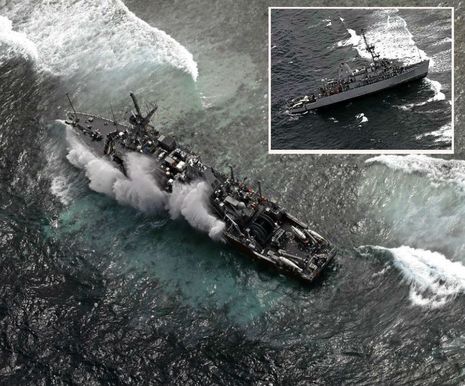
I’ve heard of hitting “the bricks” as in going hard aground — as well as “bricking” a computer (or other gadget), as in breaking it so badly that it’s only good for a door stop — but gCaptain surprised me with “USS Guardian is Fully Bricked Up and Getting Battered on Philippine Reef.” The situation is even worse since the minesweeper swung 90 degrees and is getting so hammered that it’s hard to imagine how it can be removed from the tiny Tubbahata Reefs National Park. Thankfully no one was hurt (to my knowledge) but I’m probably thinking about terminology because it’s horrible to contemplate what those pictures imply about the damage to ship, reputations, and — most important — precious wildlife. How could this happen?
Well, as the entry title implies, U.S. National Geospatial-Intelligence Agency (NGA) has already admitted that “inaccurate navigation data” on its Digital Nautical Charts (DNCs) “may have been a factor in the Guardian grounding” with reports that the reef was “misplaced by about 8 nautical miles“! The best information I seen so far — and conclusion, as in “don’t trust charts” — is on Bob Couttie’s Maritime Accident Casebook. Criminey, “the Greenpeace ship Rainbow Warrior also grounded on Tubbataha Reef in 2005” when “The chart in use showed the reef 1.5 miles from where it actually was.” Couttie further reports that hydrographic work in the Phillipines has been delayed and he kindly showed me where the relevant DNC can be viewed online. {ERROR: The NOAA site is showing NGA raster charts not the DNC vector charts that are supposedly based on them. See comments for more}…

You may well want to look yourself but some things I notice about DNC 92020 are that it’s in a very large area 1:500,000 scale and that it apparently hasn’t been updated since 1986. And what I notice about the area is how extreme the bathmetry is. Look how deep (in meters) it is around the reefs and especially notice the underwater spire known as “Jessie Beaxley Reef” to the north. All of which raises red flags navigation wise (though I can also imagine how amazing those Tubbataha coral walls must be). So could these low islets also be misplaced on the official charts, and, if so, have all the other charts followed suit?

The only other chart I have access to right now is the Navionics Gold version I got using the voucher that comes with their Freshest Data chart cards (discussed on Panbo in May). These only run in Navionics lightweight PC viewer, but I’m pretty sure the reefs are located in the same place as on the DNC, or at least quite close. But Navionics definitely provides some fresher data. Note, for instance, the “brick” about 1.5 miles northwest of the northern reefs. I added an inset which shows how it’s labeled “Rep2005” when zoomed in further. Sure seems like the spot reported by the Rainbow Warrior. Navionics also describes the islets and lagoons much differently than the DNC and I’ll bet Navionics is closer to ground truth.
I’m a curious monkey so I also made routes around the reefs in Navionics PC App and exported them to Google Earth. Unfortunately GE isn’t showing the satellite photos for the area but the outlines correspond fairly well with the data it can overlay. I even cross checked some of the GPS points indicated by the dive markers and they made sense on the Navionics chart. On the other hand, that thin “Park Area” outline of the Northern Islet looks maybe a mile offset in the Rainbow Warrior direction. Still I don’t see any indication of an 8 mile error and, besides, I’m wondering what the USS Guardian was doing in this poorly charted and dangerous area at 2:30 am anyway? And would it have helped if they had other charts to look at besides the DNCs, even an iPad running Navionics Mobile?
Anyone with ideas about how this happened, and especially anyone able to send alternate charts for comparison, please speak up. In the meantime, let us all hope that the US Navy can keep the Guardian from doing much damage to the park.


One thing I didn’t like on the Navionics chart was that just one zoom level out from what you see above, everything about Jessie Beazley Reef disappears except, weirdly, the words “White Sand Cay”. By contrast what you see on the DNC raster chart is what you get at any zoom level, on paper or screen. This is a point that came up when discussing the new NV raster charts for MFDs: http://tinyurl.com/panbo-NV-Charts-Navico
Ben, the charts excerpted in this article both show a light on the south end of South Islet. Unfortunately, there doesn’t appear to be any indication of the light characteristics. Do you know anything about how well lights such as that one are maintained in that part of the world?
There are light characteristics on the DNC chart excerpt — FL (2) 10s with visibility of 14M. If you could click on the actual Navionics chart it has the light as FL (2) 5s 15M, which is likely more up to date. (At least it has one bit of data reported in this centure!)
It’s odd that Navionics seems to be getting more data from the Philippines than NGA, which has apparently given them money to upgrade their charts. Or maybe the NGA has received updated data but hasn’t gotten to the chart yet for some reason. (I’ve seen NOAA be awfully slow.)
And besides the light there’s also that ranger station seen on the Google Map screen (click on any of those images for bigger versions). So even if the light was out, there seem to be some reasonably significant radar targets on the Tubbataha Reefs.
Ben, This is an example of why we all want as much NAV info as possible when passage making. Do you think any radar would have picked up a clue on this?
I am struck by the counterpoint of a watch – Garmin ‘Quatix’ which allows steering from your wrist and the temptation to ignore the need to be checking multiple sources to navigate safely. I do like the Quatix MOB feature for anyone who single hands though. Brian
I feel terrible for the captain, that’s career limiting. Wouldn’t a military vessel have forward scanning sonar?
What does “maintained” mean, cannot find it in the dictionary here in Philippines.
The co-ordinates of the light are 8 44.065N 119 48.64E according to Navionics android chart.
On digitised Philippine papercharts displayed in Expedition Tactical software the coordinates are 8 44.2N 119 48.75E
These coordnates tie in with those of the southern most blacked out atoll on Google Earth. (why are they blacked out)
Nothing too wrong about that!
The vessel is grounded on the southern atoll according to reports in Philippine papers. (see my post in Aiviq thread:
http://tinyurl.com/inquirer-USNavy-tubbataha-reef
Nothing too wrong about that!
Tubbataha Reef (8°50’N., 119°53’E.) are two extensive and dangerous reefs separated by a channel 4 miles wide, lying about 48 miles SW of Arena Island.
12.13 North Islet (8°56’N., 120°02’E.), a rock 1.2 meters high, covered with grass and guano, lies near the N end of the NE reef. This reef, which is steep-to, encloses a lagoon in which there are depths of 5.5 to 33 meters; there is no entrance to the lagoon. A stranded wreck lies on the E side of the reef, 2 miles SSW of North Islet. Central Islet, North Islet, and several small black rocks are the only objects on the NE reef that are above HW (high water). At LW there are numerous sand cays or ridges, each about 91m long, visible along the entire length of the reef.
South Islet (8°44’N., 119°49’E.), about 1.6 meters high, lies at the S end of the SW reef. Black Rock, and several other black rocks and sand keys, all above-water, lie at the N end of this reef. The islet is marked by a light. A stranded wreck lies on the NW extremity of the reef. Another stranded wreck is reported to lie 0.5 mile NE of the light. A depth of 262m was reported 13 miles SW of South Islet. It has been reported that the reefs appeared to have extended and increased in height. Extensive white-colored patches of sand and coral, together with numerous palm trees, were sighted on the N and NE extremities of the NE reef, and three stranded wrecks were sighted on the W side. The lighthouse was difficult to identify in daylight.
According to Wikipedia, the Guardian and her 13 sisters have fiberglass hulls supported with wood inside and are capable of withstanding relatively close mine explosions.
Wonder how’s that going to work in the coral reef.
BTW, with all due respect, the Tubbataha reef preserve is roughly 19 miles by 19 miles, or 360 miles square. The Guardian is .0003 square miles. Absent a toxic spill, damage to the reef is likely to be immaterial.
Yes, and presumably radar, sounders and watchkeepers with FLIR gear.
I can’t see how this is anything but sloppiness. If there were doubts about the charting, they could have altered course to give offing.
Sounds like an ideal case for forward looking sonar – though in these heavy seas perhaps even that would have been challenged.
I think that the only reason Google Maps/Earth doesn’t show Tubbahata is because its algorithms for ommitting unneeded satellite photography of water aren’t good enough to see the reefs.
As for the different lat/longs Anon found for the lighthouse, they only differ by about .15 nm. And the rounded locations Capt. Beck found for several Tubbahata landmarks seem to plot pretty close to what Navionics and DNC have. Then again, maybe they were taken off the original chart, which doesn’t work to check a copy of the chart 😉
But I still don’t think we’ve seen much evidence that these reefs are substantially misplaced on charts, mainly just the Rainbow Warrior report and that offset park boundary on Google Earth.
Has anyone seen a lat/long for the poor USS Guardian?
Marine GeoGarage blog : Digital map error may have led to minesweeper grounding:
http://blog.geogarage.com/2013/01/digital-map-error-may-have-led-to.html
The MCM class stands for Mine CounterMeasures. She has one of the most sophisticated surface, forward (all around actually) looking sonars in the world. As did the US Sub the cut the Japanese fishing vessel in two. Human behavior can not be replaced by machine nor monkey. It was human error on both accounts. The captains career will not be hindered by this incident, its over, as well as his bridge officer. There were many ways to avoid this incident. The 7 ps are disappearing from the Navy.
“According to Wikipedia, the Guardian and her 13 sisters have fiberglass hulls supported with wood inside and are capable of withstanding relatively close mine explosions.
Wonder how’s that going to work in the coral reef.”
She is actually constructed of wood (AYC)planking on oak frames (I own a similar albeit smaller boat) then sheathed in 20oz cloth to protect the wood from marine borers and light abrasions” The fact that she is still afloat is amazing, I have seen steel ships go down faster.
See you at Trawlerfest
Best Regards
Bill
Thanks, Peio! You’ve done some great work on your blog, though it made me realize a significant error on my part 😉
The NOAA NGA Chart screen I used in the entry shows the NGA’s raster chart, not its DNC vector chart where apparently the major error showed up.
I’ve noted the error in the text and wish I had the DNC chart to do similar comparisons, but sorry, everyone, while I think the above is an interesting exercise it may not have much to do with what happened on the USS Guardian. But then again my question about carrying more chart types still stands. I say be skeptical about them but use as many as you can.
GeoGarage also has a good photo of the Tubbahata light house and it sure looks like a decent radar target.
For other old and adled brains that don’t remember what the “7 Ps” are, Wikipedia has this:
“The 7 Ps is a British Army adage for Proper Planning and Preparation Prevents Piss Poor Performance.”
Thanks, Bill! I’ll be at Trawler Fest from about Thursday midday until Saturday evening… assuming I can get butt out of Maine and drive to South Carolina first.
From Captain Ken E Becks very detailed description of the stranded vessels locale describes 6 wrecks. The Navionics chart doesn’t show any, and the DNC chart shows 2. I’m just guessing that his info comes from IMO charts. Maybe the Navy should be using those instead.
Of course the ultimate irony would be if the vessel was herself engaged on survey work. The Admiralty currently have a number of vessels engaged on a Survey of the Phillipines, maybe the US has as well?
Steve.
There should not be ANY Navy of the world more familiar with these waters than the USN. You do not rely on charts alone. Local knowledge is in abundance. The DNC charts alone do not make a navigator just as the Iphone does not always provide you with a good alternative to maps. There is no excuse.
This photo of the Tubbataha lighthouse from Panoramio (geotagged on Google Earth) suggests that this is a fairly well maintained area:
http://www.panoramio.com/photo/19008389
As exotic as it sounds, the entire area is a UN World Heritage site and there is a ranger station on a nearby islet that hosts scuba divers — it’s a popular destination. And it’s hard to believe that that lighthouse, even if its light was not functioning, wouldn’t show up on radar.
My post is from “Sailing Direction NGA Pub 162 Philippine Islands (Enroute)”
http://blogs.defensenews.com/intercepts/2013/01/digital-map-error-may-have-led-to-minesweeper-grounding/#more-3469
Rear Adm. Jonathan White, Oceanographer and Navigator of the Navy, said in the message that preliminary analysis of the error indicates it “resulted from incorrect geographic rectification of satellite imagery used to build” the coastal DNC charts.
“But then again my question about carrying more chart types still stands. I say be skeptical about them but use as many as you can.”
Ben’s suggestion that a number of different charts to view might be helpful is exactly what we determined some years ago. We carry four different electronic charts, on three different appliances. x2 on an ipad and one each on the computer and MFD; all on a 44ft boat. Still, even with that, we went aground in Fiji. We were at less than one knot with my wife on the bow. A cloudy day, and by the time my wife shouted out (and my reaction was instantaneous for full reverse) we had run aground. I do know that in that situation, if I had one of those nice 3D FLS, I would not have gone aground. But I suspect, with the speed the USS Guardian was doing, even that probably would not have prevented this tragic accident.
Ken, do the IMO charts have better info overall?
Bill, we are still 100% paper. We use mostly BA charts, except a few places, Japan, Argentina and U.S. we use local. All are high quality but lot of effort to maintain world-wide coverage. Plus, in my view more work load for watch-standers to maintain a lower level of situational awareness.
Having spent 32 years in the Navy from 1966 – 98 I can tell you I’ve seen my share of navigation accidents all caused by human error. None more interesting than this one in 1965 when the bridge watch drove the USS Frank Knox DDR 742 onto Pratas Reef. This small circular reef is located about 200 miles ESE of Hong Kong. The Knox was enroute Hong Kong at the time of the grounding and had been well briefed as to the hazards and location of the reef. During the mid watch the lookouts reported a wave on the port bow of the destroyer and the OOD seeing it assumed it was a tsunami and turned the ship to port. The Knox steamed onto Pratas Reef at 16 knotsand the rest is history.
http://www.history.navy.mil/photos/sh-usn/usnsh-f/dd742-l.htm
It occurs to me that poorly charted reefs such as these, especially those that are UNESCO World Heritage Sites, would be perfect candidates for virtual AIS buoys. Assuming the Navy actually has AIS, they sure would have prevented this tragedy.
Paul, where in Fiji were you? The Mamanucas, by any chance?
Yes, the Mamanucas was one of the areas we visisted.
As an aside, I’m glad to see the Philippino government concerned about the reefs in light of the fact that the natives do a lot of fishing with explosives (or at least they use to) which of course causes tremendous damage to their reefs.
I did some diving while stationed there in the late 80’s and have seen it for myself.
Somewhere within the digital file cabinets of the US government there *must* exist satellite and/or aerial images, in multiple spectrums and to near-meter resolution, of every square meter of the planet’s surface. I have often thought about this, and wondered how costly it would be to re-map the globe based on a US government WGS-84 referenced database. If the US would offer this to the world I suspect it could save the planet – its people and its wildlife – a lot of grief. Perhaps it could yield benefits to humanity akin to the US’s free sharing of the GPS constellation.
Prevented it? Perhaps not; recall how many people have driven down canyons or into bogs following their GPS’s instructions because they assumed that was a better representation of reality than what they could see outside the windshield. Recall the recent raceboat deaths on the yacht Aegean: while there are no conclusive “solutions”, GPS/AP combined with inadequate lookout may have caused them to power directly into a cliff.
But AIS buoyage/markers are a good idea in principle, and I can see them as being more useful in remote, undercharted places than in busy harbours, where clutter is the norm. An AIS “hit” would really stand out in the middle of the ocean, and would provide a point of orientation from which you could plot your offing effectively.
Who, I wonder, would pay to install and maintain it, however?
I have sailed these same waters for the past 14 years and have found many errors in charting. Some basic error have happened due to the use of Luzon data for Philippine charts which seems to escape the attention of those creating electronic versions. Using the charts I have on board and in my computer I’ve plotted the light on the Sout Islet of the reefs as:
Source Lat Lon Light Characteristics
Navionics Mobile 8-44.061N 119-48.642E (2) 5s 15M
cm93 (2007) 8-44.0698N 119-48.6803E (1) 5S 15M
PI4716 8-44.1292N 119-48.9458E (3) 10s 15M
BA3809 8-44.0905N 119-48.9789E (3) 10s 15M
BA967 8-44.0784N 119-48.9907E (3) 10s 15m
Terry
Panbo, I uploaded a screen dump of the reef area as shown on the latest ENC chart of the area.
http://e-land.on-rev.com/pix/tabbaPoint.jpg
As you can see my point 9N120E is somewhat different from yours.
My ENC puts the light at 8 44.92E, 119 49.18E, also somewhat different from Terry’s.
http://e-land.on-rev.com/pix/TubbaNavGoog.jpg
Using Navionics on an iPad, I put a marker on the lighthouse and then zoomed out (see the scales). Assuming the Google image is correct, the reefs are charted 8 or 9 mile to the west of their real location.
http://e-land.on-rev.com/pix/tubbaiNavX.jpg
Same thing happens in iNavX. Desktop Google Earth does not supply the same imagery.
Time running out for USS Guardian in Tubbataha as Amihan winds intensify :
http://blog.geogarage.com/2013/01/time-running-out-for-uss-guardian-in.html
with the first photos of the USS Guardian located in the North of the South Islet, in the Comments of the blog article
Thank you, Peio, but are you confident that it’s the South Islet. I watched the video but didn’t feel sure.
And thank you too, Steve, but I suspect there was some flaw in your analysis. We have a whole lot of concurrence on the lat/long of that lighthouse, at least within a quarter mile or so. For instance Terry’s “Navionics Mobile 8-44.061N 119-48.642E” is exactly what I’m seeing on the Navionics PC chart that corresponds with Google Earth dive spots, etc. on the charts above. Plus the Navy says that only one DNC vector chart has the 8 mile mistake. On the other hand I haven’t been able to find those Google atoll outlines you show.
I’ll just leave this here:
http://www.hawaiinewsnow.com/story/20663279/navy-random-alcohol-tests-for-sailors-in-us
Ben said “On the other hand I haven’t been able to find those Google atoll outlines you show.”
Those Google reef images only appear when accessing the image data thru Navionics or iNavX, it seems. When I zoom in directly on Google Earth they do not appear. Strange, but they are different. Maybe Google knows that it is being accessed from a marine navigation app and it supplies more oceanic image data.
When I switch to Bing imagery I get the same thing. The atoll is displaced about 8 miles to the east of its charted position.
http://e-land.on-rev.com/pix/tubbaBing.jpg
Very interesting, Steve. Bing I can try, and I saw what you mean when I put the Navionics lighthouse lat/long. The light appears to be 8 miles west of South Islet. BUT if you zoom in a bit more you’ll see Hubbataha boundary lines that work fine with the lighthouse position. Check it out:
http://tinyurl.com/panbo-Tubbahata-Bing
So here’s my current theory. All the charts and positions seen above close are to correct. But the satellite photo maps are shifted about 8 miles east. Remember that the Navy says that the screwy DNC chart (which we haven’t seen) is the fault of rectification with satellite photos.
This seems particularly interesting because satellite photos look more real than charts, but in fact properly geo-positioning photos is tricky.
But why would Google imagery and Bing imagery have the same 8-9 mile error? Based on the copyright info at the bottom they are NOT using the same photo data from the same company.
OTOH, my ENC charts are probably based on (new?) Phil NAMRIA data supplied to the UK HO, and they seem to be the aligned, more or less, with the other charts. But maybe the Phils are just supplying old paper data to the UK HO.
You would think the dive sites are accurate.
Wow, this is starting to make some sense. I just got the position of the USS Guardian wreck from a reliable source: 08 49.280N, 119 48.146E
It is not 8 miles west of the charted Tubbaha Reefs but it is 1.5 miles northwest of the reef edge, almost exactly like the “Rep2005 rock” that probably represents the Rainbow Warrior grounding. Chart here:
https://panbo.com/assets_c/2013/01/USS_Guardian_wreck_position_cPanbo-6869.html
So to continue theory above: NGA cartographers know that Tubbahata is somehow mispositioned, correct it to sat photo that is even more mispositioned, bad things happen?
I don’t know, Steve, but try plotting the position of the Guardian. If they were going by the sat photo or a derivative, they thought they were about 9 miles from the reef. Of course this all theory but it seems to hang together.
Here is your position plotted on my ENC. It looks the same as your plot.
http://e-land.on-rev.com/pix/TubbaENCwreckLocation.jpg
Ok, for all of you who may know charts but know NOTHING about the vessel. Yes she has a wood hull covered with fiber glass. Because of the nature of her purpose is to sweep for mines. Hence metal will inhibit the sonar that is put in the water for the sweeping of the mines. The reason that the Guardian was there ( not in dangerous waters because the reef was 8 nautical miles away from their location) The ship does not stop during the night. She only moves about 13 knots top speed so to get where they need to be, the ship moves 24 7 until it reaches it next destination. I was affiliated with this ship for 4 years. Any more question please feel free to email them. I will discuss them with someone who has been on this ship. I will even share this article with some of the past crew so they can comment on the ricidicliousness of this journalism piece..
She is breaking up, they are now trying to offload the fuel and LO. Pics and story here. http://gcaptain.com/new-photos-show-uss-guardian-still-hard-aground-on-philippines-reef/
BT
Confirmation : Official maps and data provided by the Tubbataha Task Force indicate that the Guardian is stranded on the northwestern part of Tubbataha’s South Atoll:
http://www8.gmanews.tv/webpics/v3/2013/01/USS-Guardian_location_25Jan2013.jpg
I believe that those islands and reefs out there move all over the place or what Amelia Earhart told me was wrong!
Bill I read your comment, no where in the story does it say she is breaking up. It says the hull has penetrations. Meaning cracks.
I have compared my ENC to the photo of the Navy’s plot. http://e-land.on-rev.com/pix/guardianCombo.jpg
You can see they are using a paper printout of the same ENC data (the depths are all the same) that I am using.
The distance from the plotted point to the edge of the reef is 0.75nm, so the ENCs are off by that much to the S and a little to the E.
Here’s a follow-up article in this morning’s New York Times:
http://www.nytimes.com/2013/01/26/world/asia/us-envoy-apologizes-for-ships-grounding-in-philippine-coral-reef.html?ref=asia
Steve, I think that the Guardian position I was given puts it about 1.2nm NNE of the nearest generally charted reef. But that position is also 1.5nm NE of the reef edge, which is very close to the offset that the Rainbow Warrior reported in 2005 and that seems to be on the chart.
Misplacements like this tend to be consistent because even the earliest surveyors could do accurate work in fairly close quarters. Satellite positioning systems changed the game a lot because then all the cartography had to be made consistent with an accurate model of the globe, which is not as round and fair as one might think. Nigel Calder does a great job of explaining all this in the early sections his “How to Read a Nautical Chart” which got a nice update last year.
PS Did you plot the Guardian on Bing and/or do you agree that the Bing sat photo is more offset than the charts we’ve seen? And, by the way, what do mean by ENC? That’s a pretty general term except that NOAA uses it for its vector charts. Who created the chart you have?
In re LEESA. The story is, she can not be floated off and has significant flooding and holing in many compartments. I also personally own a smaller version (80 feet) of this boat built by the same yard.
I know these vessels intimately and as naval and industrial engineer I can tell you emphatically that she is breaking up!
BT
From Defense News this morning:
“The National Geospatial Intelligence Agency (NGA), creator of the charts, conducted “a comprehensive analysis of all DNC libraries,” White said in the message, and confirmed the error in the location of the Tubattaha Reef in the western Philippines, which the minesweeper Guardian struck in the early hours of Jan. 17.
The NGA reported earlier the location of the reef on the DNC charts was about eight nautical miles away from its true location.”
“Additional significant errors” — up to four nautical miles — were found along the southwest coast of Chile, White reported in his messages. Those errors, he wrote, “are reflected on DNC and paper charts. NGA has issued warnings on those errors to all mariners.”
Thank you for the update Bill! This is surly good news for future sailings for people whom use the DNC charts. Not just for the US Navy.
I have been following this horrible event from day 1, with all info I have been able to find. Only found this site today.
Elsewhere I was reading info posted by some very knowledgeable navy types, and they were saying that the navy has gone paperless as of 2011. And the hi-res DNC chart was showing the reef being 8 mi. displaced. The lo-res chart is correct.
My point is that even if the reef is misplaced, the lighthouse sitting on it would also be misplaced. It is a 15 mi. light that surely must show on .mil radar from more than 5 mi. the distance it is from the wreck. Along with the other wrecks o the northwest corner of the reef, there are reportedly several 14ft. high dive buoys in the area.
One would think that somebody would be glancing occasionally at the radar while transiting in the area of shit to hit. All this stuff would show up as being in the ‘wrong place’ which would surely raise the question of ‘wots up?’
Even with the whole reef, lighthouse, wrecks and buoys being in the wrong place, the relative shape and positions would stay the same.
And at 14 knots, the radar image is not exactly screaming off the screen. There was reportedly 4 or 5 persons on the bridge, what were they doing?
These reefs were the only thing around for many hours, one would think that somebody would be ‘interested’ in their location. If for no other reason than something to look at, to break up the boredom of a night watch. But then, I don’t know what the navy does to ‘stay busy’ on watch.
YMMV
andyb
Couple of thoughts. Some posters have commented that the ship should have been using forward looking sonar. Navy ships equipped with sonar are extremely reluctant to actively transmit sonar because it immediately advertises the ship’s presence to any other sensors across a wide area. Furthermore, the ship was transiting through an area they thought was thousands of meters deep. Regarding the fathometer, Navy regulations only require the fatho to be energized when operating in piloting or restricted waters. Again, advertising the ship’s position is a concern. Same with AIS. Navy ships will TRANSMIT AIS only when the Commanding Officer feels that the benfits outweigh the potential threat to the ship. In fact, navy ships will occasionally shut down ALL transmitters – including radar – if the tactical situation demands it.
Now all that said, on an open ocean transit,they were almost certainly using their surface search radar. They also had several people on the bridge presumably looking out the window. Yet the fact is they hit a reef that HAD A LIGHTHOUSE ON IT. The Officer of the Deck was not doing his job. The lighthouse and the nearby wrecks, breaking surf, and islets should have presented a radar return that didn’t look like open ocean. Assuming it was a clear night and the light was working, the light’s range was 14NM, and ownship speed was approx 14 knots, they had about an hour of looking out the window at the light… yet NO ONE thought, “Gee, that light doesn’t correlate to anything on the chart…” This is what too many navy navigators do. They take the GPS and electronic charts at face value and sit back and relax. This is a good lesson for all of us, because I’ll bet we’ve all done this at some point. Bridge watch officers need to be curious, vigilant, and engaged.
These sort of accidents are a lot more common than we are led to believe. Occassionally a high profile one like this hits the headlines. Similar to last year when a British Nuke Sub gounded itself on a well charted sandbank in Scapa Flow. If one or two of these incidents hit the headlines now and again, one wonders how many others do not and are covered up by the MoD/DoD.
Just a thought.
Steve
A few comments on geospatial data and positioning (from a satellite imaging specialist).
1. The DNC Raster suggests that the origin of the data is a Philippine chart from 1961 (corrected 1974) mapped at 1:60000 scale. Mapping accuracy is not reported nor is the source of the original chart.
2. It is noted that datum information in the original is uncertain. That means the position of the mapped reef is uncertain (an a analogy being if your route was mapped in feet but reported as being in metres).
3. On a related note: positions from GPS are in WGS 84 datum, geographic (lat/long) coordinates. I am not sure what projection the marine charts and vessel were using but this could easily result in large geolocation errors. Also, how many decimals used in the charts, the vessels own plotting etc is not reported. If using Lat/long this is important.
4. The latest update (1986) is to add a depth of 140 m to a given location; this does not imply a full revision.
5. The light house may not make a terribly good radar target as the concrete face is faceted (rather light a stealth aircraft or vessel) and the material may not be a great reflector. That said it’s a pretty big object.
6. The World has a large surface: mapping all of it using high res. multi-spectral satellite imagery would be a huge job. Furthermore, in locations like this you would ideally want surveyed ground targets to ensure precise geolocation/correction.
7. We don’t know anything baout how the raster data were vectorized and if there were systematic quality controls. This is yet another area in which error could creep in.
In summary, the geospatial data used might contain positional inaccuracies on kilometre scales and should probably be regarded with a degree of caution. Don’t rely on other people’s data unless you absolutely have to.
In 1944 we had a fleet of warships plying theses waters with no electronic nav aids. Radar and Sonar had just come to the Navy a few years before and was crude by our standards. We never ran into this reef with our warships and those boats drew 2- 5 times as much water as the Guardians 13 feet. There is no excuse! With my small radar today I can pick out individual birds let alone a lighthouse. The Guardian was a 60+ million dollar boat with the highest technology available and upgraded many times. Flank speed on the new boats was 14 knots. She was probably cruising at 10. Her Radar can pick out a semi submerged container. The Crew on the bridge was derelict. The Captain responsible for the dereliction. Will he or they be prosecuted? I know I would be.
Her radar: AN/SPS-55 I-band surface search and navigation radar. It is designed for service on ships of destroyer size or above. Operational uses are: the detection of small surface targets from ranges of less than 50m to the radar horizon; navigation and pilotage; tracking of low-flying aircraft and helicopters; detection of submarines at snorkel and periscope depth. With an integral IFF tracker (like MARPA) capable of 200 targets (JANES)
Manufacturer: Raytheon/Cardion Electronics
IEEE Band: X Band linear horizontal or circular polarization
Frequency: 9.05 to 10 GHz
Peak Power: 130 kW
PRF: 2,250 or 750 pps
Pulse Length: 0.12 or 1 usec
Minimum Range: 50 Yards
Maximum Range: 50+ miles
Beam Dimensions: 1.5° x 20°
Gain: 31 dB
Scan Rate: 16 RPM
IFF: 200
http://www.cardionelectronics.com/miscellaneous/an_sps-55
http://what-when-how.com/military-weapons/naval-radars-military-weapons/
Further, she was equipped with the latest AN/SSN-2(V) PINS (Precise Integrated Navigation System) is an integrated, GS-based computer navigation system designed for MCMVs. The heart of the PINS is a powerful military computer interfaced with an array of commercial and military sensors, control units and data display and recording systems. The PINS uses a Kalman Filter routine to smooth received data and apply appropriate corrections for known error factors. The system integrates and compares data from multiple navigation aids and other sensors to perform precise navigation and position determination, mission planning, plotting and data recording, target location and positioning and post-mission analysis. The GPS system is used to provide navigation fixes, interfaced via PINS with the ship’s Doppler sonar operating in either groundspeed or water speed modes. Other interfaced systems include Hyperfix. All contacts and their positions are recorded and displayed, together with the ship’s track, on a vertical plotter in the operations room. The high-speed vertical belt-fed plotter provides a hard-copy printout using standard navy charts if required.
From: Military and Aerospace Electronics
Lockheed Martin to build precise navigation systems for Navy Avenger-class mine-hunting ships
MANASSAS, Va., 24 Dec. 2006. The Lockheed Martin Maritime Systems and Sensors segment in Manassas, Va., won a $644 million contract for AN/SSN-2(V)5 navigation command and control (NAVC2) precise integrated navigation systems for U.S. Navy Avenger-class mine countermeasures ships.
The Avenger-class mine countermeasures ship USS Guardian, will receive the AN/SSN-2(V)5 navigation command and control (NAVC2) precise integrated navigation system.
The NAVC2 system is a major upgrade to the combat and navigation system for Avenger-class ships. It is an open-architecture system that supports future major combat stem upgrades to MCM-1 class ships and electronic chart and information display system-Navy capability. Comprising commercial satellite navigation, Hyper-Fix, and a Doppler sonar navigator that is integrated and controlled by dedicated MCM software, the NAVC2 provides the means to locate the ship and the target precisely. The system maintains and displays the ship’s track, and integrates the target mine information into the navigation plot. The computer-controlled navigation process can select the most accurate of the several navigational inputs available. Avenger class ships are mine hunter-killers capable of finding, classifying, and destroying moored and bottom mines. The ships perform precise navigation and clear mine fields by sweeping moored, magnetic, and acoustic mines. The MCM also conducts coordinated operations with airborne and other mine countermeasure forces.
The Guardian will now be cut up while on the reef.
http://gcaptain.com/stricken-uss-guardian-broken-up/
This should be a 100 million dollar “lessons learned” for all of us. Trust your eyes and ears (and nose). While I love today’s electronics (we even build them for commercial boats), they do not replace Human senses and reasoning. Use all the tools available to you. Complacency to the boater can and usually does end in tragedy.
I hope this is not the end of this story.
Best Regards
Bill
—
Bill Taylor
VP Engineering
TTA MARINE LLC
Holiday, Fl
It really is tragic that this had to happen. Hopefully, the charting would be fixed so that stuff like this should not happen again in the future. There really is no need to point fingers and let’s just hope that they can actually reach some point of consensus to make sure that everybody has the same charts.
A matter of intrigue is that she’s left Subic Bay on 13 January and was supposed to be heading directly for Indonesia. She seems to have been steaming very slowly if she only got to Tubbataha on 16 January.
It’s a little unfortunate that navigators are advised not to depend upon satellite-derived positions in that area and to take bearings.
I’ve be there for diving last year diring 10 days.
The place is really beautifull.
I know the light and the ranger station.
It’s impossible lo miss the islet or the Ranger station on any radar!
Only DNCs are approved for navigation with appropiate/USN approved/qualified gear for this vessel. The error on the DNC was never discovered or their location verified. The “human error” occured on the part of the DNC producers – not GUARDIAN.
I understand that the DNC was in error. However, as I posted above, the lighthouse and Ranger Station would have been obvious on radar. If somebody had been looking, those two objects would have shown up as being in the wrong position. If the DNC said that the lighthouse was 8+4 mi. away, and the radar said it was 4mi. distant, somebody should have seen the error.
Regardless of the error in position of the reef on the DNC, surely the relative position of the the lighthouse, 4-5 miles distant, right on the nose, and the Ranger station on the beam, should have gotten somebody’s attention.
I dont know how the Navy manages a watch, but I understand that there were 4 or 5 bodies on the Bridge. What were they doing? The ship was within a few miles of stuff to hit, in the middle of a large, essentially land-locked sea, one would think that somebody would be looking at ‘stuff to see’ if for no other reason to break up the boredom of an at-sea night watch.
Based on the above description of the electronics installed, and the extreme integration of it all, I’m amazed that some alarms didn’t go off.
So blame the ‘human error’ on the DNC people, yes, but I find it hard to believe that if just one of those 4 guys on watch had been looking out the window, or at the radar, this nightmare could have been avoided.
Tell me I’m wrong.
Sounds like your ignorance of the overall situation has clouded you head.
You ARE wrong – a Monday morning quarterback at best. Besides it was 0225 and dark as pitch. Your entire comment is erroneous speculation. YOU weren’t there.
So, Anonymous, you were there. Perhaps you can tell us what you could see on the radar and by visual observation.
I am not at liberty to comment on that specifically. I know that this foolish speculation does nothing, absolutely nothing, to help the crew of this vessel work through the horrors of those pitch black, early morning hours of January 17, 2013. Many of you who have second guessed, surmised, assumed, speculated, and questioned their responses as to what happened (along with the other so called “press”) has hurt these heroic men deeply morale wise. They were “by the book” all the way and have not been faulted. Their heroic actions saved their shipmates lives. They all “did the drill”, did all they could to save their ship with nearest help hours and hours and hours away.
No, I was not there… but my son was.
No-one has impugned the courage of the men aboard USS Guardian. Their actions after hitting the reef were absolutely correct. It must have been terrifying.
I have, in fact, debunked a number of myths that surfaced after the grounding.
That said, a faulty chart has never absolved a master of his responsibility for a grounding.
Anonymous, I’m truly sorry that your son is involved in this mess, but you need to relax a bit. This sort of conversation happens around any marine accident, and it’s a valuable conversation as it helps the rest of us understand what can go wrong.
If you check out Bob Couttie’s web site, you’ll see that his profession is analyzing accidents like this, and if you check out publications like Professional Mariner, you’ll see that they detail marine casualties every issue:
http://www.professionalmariner.com/Casualties/
The truth is that a vessel should not be lost because of a single error in a chart or anything else. Even recreational boaters like myself have multiple ways to cross reference our boat’s position and safety. A ship like the Guardian had even more resources, and this accident should not have happened.
Another truth, unfortunate though it may be, is that a mariner can do right through his or her whole career but then a single major failure can become its most important aspect. Hopefully your son was neither the captain nor the watch officer because blame always starts at the top, and rightfully so.
It’s also good news that no lives were lost, and if there were heroics involved in that, I’m sure they will be recognized.
Easy Anonymous, the investigation is still going on. I would urge you to not post any further knowledge of the incident for the sake of the sailors. People are watching. Sincerely Leesa Anderson.
Here’s an update. Note: “As of yesterday, Lt. Cmdr Rice, his Executive Officer/Navigator Lt. Daniel Tylor, the ship’s assistant navigator, and the Officer of the Deck have been relieved of duty by Rear Adm. Jeffrey Harley, Commander, Expeditionary Strike Group (ESG) 7.
The US Navy comments that an investigation continues however, according to a US Navy statement, initial findings clearly indicate that the above mentioned sailors did not adhere to standard U.S. Navy navigation procedures and were relieved due to their role in the grounding and a loss of confidence.”
http://gcaptain.com/senior-leadership-ex-uss-guardian/
Not unexpected:
“Lt. Cmdr. Mark Rice, executive officer Daniel Tyler, the ship’s enlisted assistant navigator and the officer of the deck at the time of the ship’s grounding were all relieved because they “did not adhere to the standard navy navigation procedures,” Expeditionary Strike Group Seven spokesman Lt. Brian Wierzbicki said.
Rice and the others were relieved by Rear Adm. Jeffrey Harley, commander of the Sasebo, Japan-based Amphibious Force 7th Fleet. Harley cited a “loss of confidence” in Rice’s ability to command, a common reason cited when Navy commanders are relieved.”
Bob, Its obvious to me that you can read. Congratulations, but before plagiarizing, make sure you do it correctly. The Assistant Navigator is an Officer. If I haven’t stated it before I will say it now My husband was on this ship for 4 years. Before I post anything on any site I learn my facts. I suggest you do the same as it makes you more credible. Also plagiarizing is a crime believe it or not. Should we fire you? I am also educated. I also would like to know if your vast navel knowledge believes that “the officer of the deck” is actually an U.S. navel Officer? LOL sorry couldn’t help but to throw that in.
Sincerely,
Leesa
Leesa, a direct quote from a source which is cited is not plagiarism. I trust you will go and complain to the source. Yes, I can read. I also know how to spell ‘navy’ and naval’.
Since the officers have been suspended for the reasons given the report is accurate.
Your second Quote was not cited. The one at 8:28 PM No need for me to run to anyone. Just pointing out how easy it is to not have faith in ones ability.
The second quote is a repeat of the first, therefore no additional citation is needed. It is in quotes, which clearly indicates that it is the work of another and therefore not plagiarism.
To clarify your question, the officer of the deck is a position, not a rank. It is a US Navy officer who is assigned to that position by the commanding officer.
A US navel officer is responsible for belly-buttons.
Ben, I’m all for freedom of speech and letting people express their opinions. But I wonder if Leesa’s repeated snarking at Bob is something to which we all need to be witness. I find it distracting from the information that most of the comments in this thread are trying to find or provide.
It makes me uncomfortable too, Jim, but though I don’t know him I sense that Bob has a thick skin and I’m also willing to give Leesa some slack because she is emotionally involved with the accident.
But that said, Leeza, please refrain from attacking other commenters here. Besides, your accusation of plagiarism is ridiculous, and that’s a subject I know something about. And, Bob, thank you very much for keeping this thread apprised of what’s happening in the aftermath.
That sounds fair, Ben. Thanks for your response!
Jim
On a more positive note, the reef management office says that less damage has been done than it previously estimated, around 2,350 square metres against an initial TMO estimate of 4,000, and the reef is showing signs of recovery. http://www.gmanetwork.com/news/story/302616/news/nation/tubbataha-damage-from-uss-guardian-less-than-earlier-estimates
There are two main investigations going on, one by the USN and a separate one by a Philippine accident taskforce. Of interest is tht the latter is being done supposedly in compliance with the IMO casualty code. This is the first investigation ever carried out in the Philippines under the code and I have my doubts about the legal ability to really do an IMO-compliant investigation in the Philippines where any ‘competent court’ can demand investigation data to determine liability. Having trained some Philippine coastguard personnel in accident investigation I don’t think the legal structure is in place.
BTW having lived in Subic Bay, from which the Guardian departed on her last voyage, for nearly 30 years I do have a sort of proprietary interest in the case.
A Chinese fishing vessel, poaching on Tubbataha Reef, has just grounded. 1.1 miles sounds familiar http://www.interaksyon.com/article/58980/after-uss-guardian–chinese-vessel-runs-aground-in-tubbataha
Update:
The US has just handed over ‘documents’, including the digital chart, to the Philippines Investigation team.
Also, it’s been revealed, apropo the Chinese fishing vessel grounding, that the radar on the reef is only switched on every three hours.
Leesa,
By regs, the XO (an officer) is the Navigator. On these ships the ANAV may be the Department Head or Division Officer of the Navigation Dept/Div; many times it’s the Leading Quartermaster who fills the ANAV position. In this specific case, it was the latter.
Ex-Force Navigator
variable depth sonar only lowered during mine hunting
Another issue dealing with vector charts is the information is both from a raster source and programmatically displayed info (layers) that can be translated incorrectly from the underlying raster chart’s information, or there is not enough control in how the info is display. Case at point, the Chart 11485 is the raster chart of the ICW near Saturn Barge Canal (SBC), Merritt Island, Florida. When reviewing the height restrictions near G67, on the ICW just north of the SBC, on the vector chart (Chart 11485(B)), the overhead power cable is listed as 45 feet high. Yet on the raster chart 11485, the height is listed as ’85 feet center of the channel.’ I believe the issue is the height is 45 feet on either side of the main channel but the height goes up to 85 over the limits of the ICW channel. There is apparently no way to display a variable height on a single object (the overhead power lines) at different distances. The only way to have depicted the single object with two heights would have been to add a new ‘variable’ dimension to an object’s vector info. Another -cheap- way would have been to break the single object up into two objects, whereby the first one on either side (possibly take 3 objects) of the main ICW channel would have been 45 feet, and the object directly over and no wider than the main channel would have been ‘dimensioned’ with a height of 85 feet. I am not sure I like the second method of fixing the ‘variable height’ issue of a single object, as it would look as if there were indeed 2 (possibly up to 3) different sets of the same overhead power line, when indeed there was only one object, a single set of power lines crossing overhead. While this is nowhere as severe as a grounding of a minesweeper, and in this case the error was in the direction to cause no harm, but it is true the error made me decide that I could not take my boat in at the Cape Canaveral entrance and travel up the ICW to the Titusville Marina. This is an accidental loss of business for the Titusville Marina (but it was caught just in the nick of time before any decisions were made, mainly because everyone looked at me funny when I mentioned the ’45-foot power lines’ at that location that no else has ever seen!).
The Navy report of the USS Guardian grounding is out and not surprising. Maritime Executive reports:
Adm. Cecil D. Haney, commander of the U.S. Pacific Fleet, wrote in the 160-page document that “USS Guardian leadership and watch teams failed to adhere to prudent, safe, and sound navigation principles which would have alerted them to approaching dangers with sufficient time to take mitigating action.”
Haney further summarized that a “lack of leadership” led to the watch team’s disregard of visual cues, electronic cues and alarms in the hours leading up to the grounding, and that an ultimate reliance on what would turn out to be inaccurate Digital Nautical Charts (DNC) during the planning and execution of the navigation plan ultimately led to a degradation of the ship’s navigation ability.
http://www.maritime-executive.com/article/USS-Guardian-Grounding-Investigation-Results-Released-2013-06-21/
The Navy investigation confirms it was flashing every 5 seconds and was spotted by the quartermaster who tried to convince the OOD that it was a light. The report puts the blame totally upon the vessel’s leadership. I believe it fails to address the chart contradictions – just like the report on the sub which hit the uncharted seamount.
She was in transit to Japan and had no clearance to enter Philippine waters.
“She was in transit to Japan and had no clearance to enter Philippine waters.”
1: She was travelling from Subic Bay in the Philippines. She was on her way to Indonesia.
So, she came from Philippine waters and was on her way to Indonesia, having abandoned a re-fuelling stop in Puerto Princessa, which is in the Philippines. So she had clearance to enter Philippine waters.
2: The US navy does not recognise anything other than a 12 mile limit around Philippine islands and reefs. It is in dispute with the Philippines on the issue and was exercising its right of innocent passage. US Navy instructions are to keep at least 12 miles away from recognised Philippine territory, which includes Tubattaha Reef. Had Guardian done so she would not have grounded even given given her reliance on the faulty electronic chart.
The Navy Report commends the actions of the crew in damage control and says that they were upholding the best traditions of the Navy in not giving up the ship.
Indeed, there were heroes and I suspect some medals will be forthcoming, well-deserved.
Interesting article on where some islands are, and aren’t…
http://arstechnica.com/science/2013/06/the-story-behind-the-island-that-wasnt-there/?comments=1&start=40
If it looks like a Pink Teddy Bear, smells like a Pink Teddy bear meteor, it probably is a Pink Teddy Bear reef, either on the part of the navigator or the chart manufacturer. – Goldfish
In June of 1949 the SS Flying Cloud ran onto Tubbataha’s south islet I worked on the succesful salvage by luzon Stevedoring Later while researching the Guardian grounding I determined the 1949 position was 14 NM miles SW of it’s correct location. BTW over 20 vessels have grounded on Tubbatah in the last 100 plus years.