
Garmin G2, talk about photography!
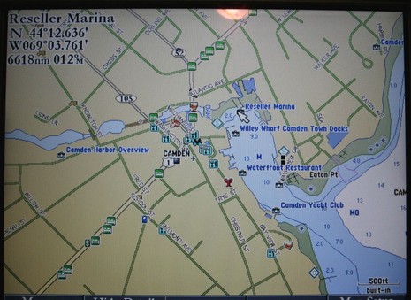
Garmin G2 cartography was announced in November, more detail came out in March, and now I’m actually looking at it, both versions. Yes, remember that G2 (or g2, as Garmin spells it) comes in two tiers. The 3210 I’m testing has G2’s of the whole U.S. built in; they are full detail charts with added major roads and some port info. But you have to buy and insert a G2 chart card to get all the photos, full street maps, and multiple POI’s seen above, and bigger here
. Pulled back a bit you’d see that there are about a dozen photos just for Camden, which rather amazed me. Some are oblique, some straight down, many are higher resolution than you’ve ever seen in a navigation product before. For instance, I can make out my 14’ Gizmo tied up in the shot below (bigger here). Garmin has a ways to go to make all this photographic wealth easily accessible—like making the icons more indicative of what the picture shows, and making it possible to page through all of a port’s pics without going back out to the chart—but I’m sure it will happen. I also see a few errors in the port data but that’s nothing new. For instance, almost every electronic chart shows Willey Wharf and the Camden Town Landing as one place with a common phone number, but they are quite separate operations (there’s either been a lot of copying or data licensing going on). Also “Reseller Marina” is completely new to me and I’ve been in this harbor for 35 years and am on the Harbor Committee! I’m looking forward to trying the 3210 and G2’s, both versions, on the water soon. (The cards, by the way, retail for $215 in Garmin’s regular sizes, and $321 in large sizes. And speaking more generally of chart data sources I was interested to see this list of hydrographic offices including what Garmin has signed up for.)


Funny that Willey’s Wharf is listed there, but Wayfarer is not. How much do you have to pay to get included on the charts?
Ben – Just think how Gizmo would look if the 3210 had better than VGA resolution.
Ben, do the Garmin g2 maps display tidal flow arrows and if so, is it as intuitively displayed as the yellow arrows used by C-maps?
Many thanks Paul
Paul, I’ll have to check those current arrows; so far I haven’t noticed them, but I haven’t actually spent much time with the machine. That will change. As for the C-Map current arrows, I thought they were kind of clunky on a Simrad CX34 but look good in PC Planner.
PS Eli, Wayfarer is definitely in G2, photos and data, but just didn’t show up at this zoom level.