
AIS simulation, a couple of ways
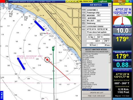
In a week or two, yet another ECS, Tiki Navigator, will add AIS targeting and it looks well done. Note in the screen shot (bigger here) how the red target is being DR’d, its last actual update shown by a little circle and the time of that update shown in a window just below its position. I know that some may find this is too complex, but I think it might be useful, especially with slow Class B data updates. Tiki can also draw a target predictor line based on ‘x’ minutes of speed/course, and it scales vessels if they’re sending dimensional info and if you’re zoomed in enough. Included in the demo file will be some charts of the Seattle area and a NMEA 0183 data file showing real AIS traffic.
Simulation is valuable as a lot of navigators have yet to experience AIS in action. You may recall that Capn Voyager can read a web stream of live AIS targets, which is even better than simulation (though I’m not sure that feature is still available). And Fred Pot at SeaCas has set up a way you can replay a voyage, AIS targets included, in Coastal Explorer (or Maptech Navigator Pro). Look for the “To see a demonstration” link at the bottom of this SeaCas page. I’ve tried it and it’s cool, including a close quarters “start the engine!” situation and AIS targets seen 30+ miles away, and on the other side of islands, all using Fred’s 300 model mounted on the stern rail.
By the way, I have heard that Class B AIS is selling well in Europe but not a darn thing about approvals and availibility here in the USA. Anyone?


Ais has enormous potential, but my experience with it in Long Island Sound is it is not being used enough to become a valuable tool for the navigator. I suppose it is like when email came into existence… until enough people had an email address there wasn’t much you could do with it or communicate with enough people. Now you can and even catch them on the cell phones etc.
When AIS is more universally used it will be terrific… assuming that there would be a way to filter lots of targets in busy areas. You chart might look like a plate of spaghetti of a game of pick up sticks…
The notion that a processor could receive the signals and show you all potential collisions.. and filter out non threats seem the way to go. DO I really need to know that there is a tanker 25 miles away? Perhaps if I were offshore and in need of assistance… but I don’t need to know the shipping in Naragansett Bay approaches when I am in Block Island Sound.
This is a very good tool for vessels where there is someone who can be watching the instruments ALL the time … as opposed to a short handed vessel where you only get the odd chance to look at a plotter because you are scanning the horizon or driving the boat.
The concept is great… like a smarter radar… for moving targets only.
Do you think they will equip major buoys with AIS type transmitters?