Category: Wireless & Apps
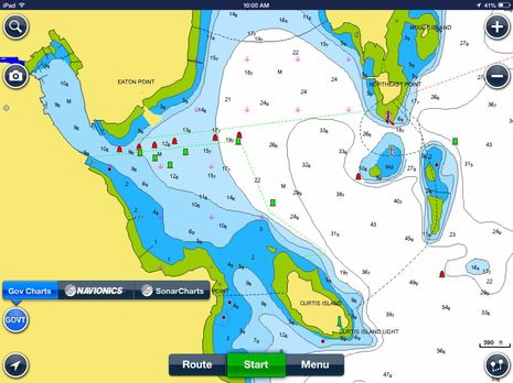 This is a significant surprise. Version 7.0 of the free Navionics Boating app released today for iPad and iPhone includes the ability to download and use NOAA vector charts, as seen above. Meanwhile, if you already own a Navionics Marine app for iOS, there’s a 7.0 update available which adds “Gov Charts” and the same feature will soon come to Android versions of both the Boating and Marine apps. Navigators who already use Navionics charts on a tablet or phone may find it useful to have NOAA data for comparison, but the big news is that any U.S. boater can now enjoy a Navionics level charting app completely free…
 “Two way” doesn’t just refer to the fact that a DeLorme inReach handheld satellite messenger/tracker will let you text back and forth with people pretty much like a cell phone. I also tested the shore side of the system by loaning the sample inReachSE model to friends Doug and Dale Bruce when they went on an adventure cruise to some remote islands south of New Zealand. So that’s me messaging from Maine when I saw where they were headed (via their MapShare track), and then Doug texting me back a few minutes later. Yes, he had a little trouble with SE’s little cursor keyboard, but heck, he was in rough seas on the other side of the planet!
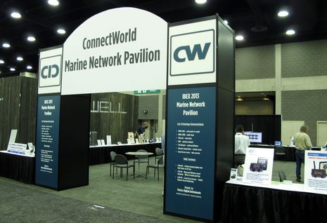 A surprise high point of last year’s International Boatbuilders Exhibition (IBEX) was ConnectWorld. For several years the National Marine Electronics Association (NMEA) had staged a substantial ConnectFest NMEA 2000 networking demonstration on the show floor — remember the Fish Gate 100? — but for some reason they dropped out in 2013. I was skeptical about a hurried effort to keep the idea alive managed by a manufacturer instead of NMEA. What I found, however, was that Chetco Digital Instruments had put together a nice demonstration of multiple brand devices sharing data across multiple networks. While NMEA 2000 made a lot of it possible, there’s some great development going on beyond the N2K backbones and I’m excited about what we’ll see in Tampa at IBEX 2014…
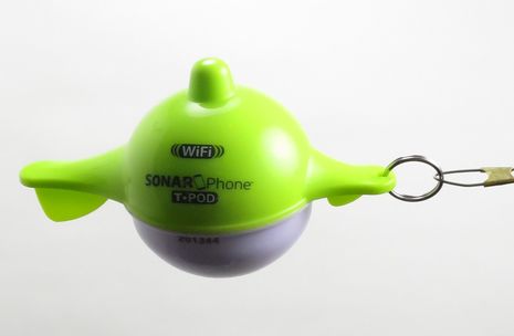 It’s 2014 and a sealed plastic 5-inch bobber can indeed contain a fairly able 400 Watt 125 kHz fishfinder and a WiFi radio, plus enough rechargeable battery to run both for a few hours. The SonarPhone T-Pod will strike many as a toy, but it actually works quite well considering its small size and price tag ($130). And the manufacturer Vexilar puts the same technology into models meant to install on small boats, which means that dedicated iPad (or Android tablet) boaters do indeed have a fishfinder option…
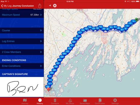 I wish that track was on the water, but testing WaveTrax auto boat logging over the road is impressive nonetheless. Running on my iPad mini, the app not only collects a track point every minute but automatically creates log entries marking my Lat/Long, COG, and SOG on the hour (and at user selectable distances). It’s fairly easy to add notes, captioned photos, engine/fuel status, and weather observations as desired, and when a trip is done, I even get to touch scribble a signature. But that’s hardly half of it…
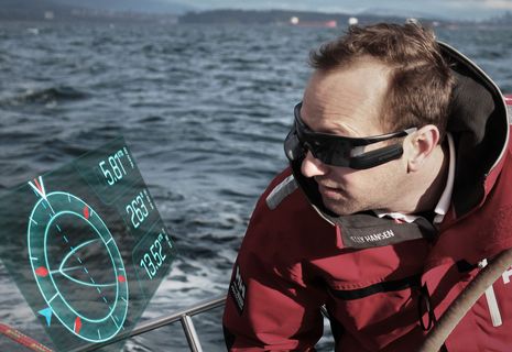 The goal is to direct your focus wherever it’s needed on or beyond the boat while still having critical data in sight. Brand spanking new today is the Afterguard heads-up display (HUD) for racing sailors. Yes, recent America’s Cup skippers apparently used HUD sunglasses, though you’re a better researcher than I if you can find detail about how they worked and what data they provided. Afterguard intends to bring this technology down at least a few levels, and that means we get a better look at what it can do. This sort of product is more than a little out of my wheelhouse, so to speak, but it looks like this new company did its homework and made some smart decisions…
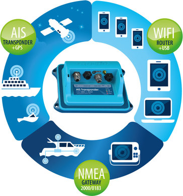 I’ve had a Vesper XB-8000 installed in the lab for the last month, and am confident that it will do well in a long test on board Gizmo beginning in May. I will miss some features of the Vesper Vision I tested last season, but having the blue box installed behind the scenes will help me test the glass bridge concept (one MFD brand, many screens), and at $799 I think the XB-8000 is a multifunction value that could work on a wide variety of vessels. The recent testing also revealed some new features that apply to both the XB and the Vision as Vesper continues to expand on the concepts expressed in the 3-in-1 diagram above…
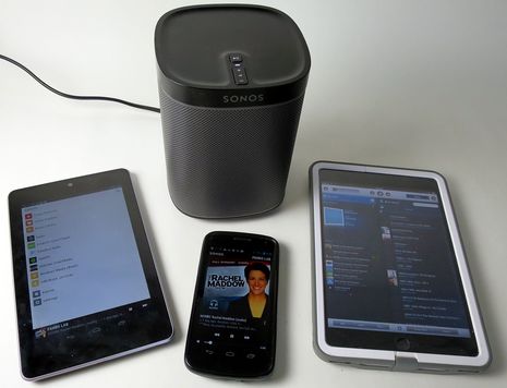 I knew little about Sonos wireless hifi a month ago. While the ads suggested an elegant Apple-like design, I had the impression it also came with Apple-like premium prices and was certainly not suitable for boats. But now that I’ve lived for a month with the relatively new Play:1 seen above, I may have been wrong on both counts! Many reviewers have already praised the little speaker/amp’s hardware and audio quality compared to similar wireless speakers. I want to detail the superb Sonos audio access and control software that you can tap into with just one $199 Play:1(though adding more components will be a huge temptation) and also discuss how Sonos can make sense afloat.
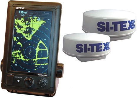 There’s more to the new Si-Tex T-760 Series radar than you’ll currently find on that product page. Those multi-speed radomes are unlike anything Si-Tex has offered before and contain digital processing that will eventually put 16-level true color target imagery on that 800 x 480 pixel touch screen (with a software update). Plus the case is carved from solid aluminum and can be easily flush mounted. At a suggested retail of about $2,100 with the 18-inch radome and an impressive set of radar features, the T-760 looks like an interesting alternative for boaters who don’t want all their electronic navigation tools on a multifunction display. It might also work for those early adopters who can’t get radar on the tablets they want to use for primary navigation…
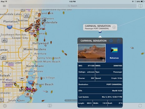
These days I feel obliged to include a warning every time I write about AIS over the Internet. What you see in a nice app like ShipFinder HD (above) probably does not include every vessel that’s transmitting AIS info even in fairly well covered areas like the Miami/Lauderdale area, and many areas aren’t covered at all…unless perhaps you’re using the Seapilot app in Sweden or somehow have access to another well-organized AIS receiver system. That’s because what most of us see on computers, phones or tablets connected to the Web is target data collected by patchy networks of volunteers whose shore antennas may well miss even fairly nearby 2 Watt Class B AIS transmissions or even 12 Watt Class A signals obscured by buildings or terrain (or may suddenly go offline just because the volunteer’s kid trips on a power cord or similar).


