
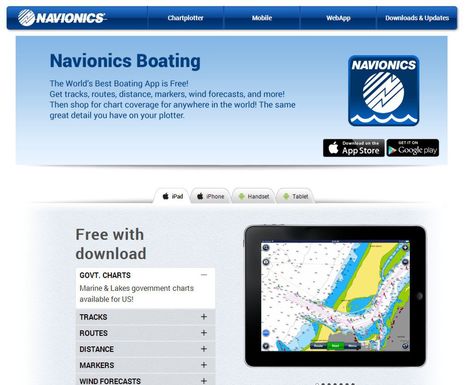
Navionics Boating app, now with free U.S. charts!
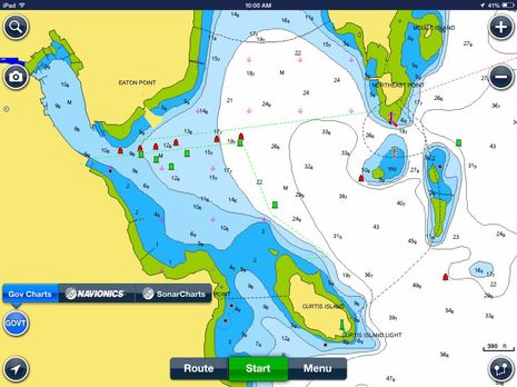 This is a significant surprise. Version 7.0 of the free Navionics Boating app released today for iPad and iPhone includes the ability to download and use NOAA vector charts, as seen above. Meanwhile, if you already own a Navionics Marine app for iOS, there’s a 7.0 update available which adds “Gov Charts” and the same feature will soon come to Android versions of both the Boating and Marine apps. Navigators who already use Navionics charts on a tablet or phone may find it useful to have NOAA data for comparison, but the big news is that any U.S. boater can now enjoy a Navionics level charting app completely free…
Before getting further into what Navionics is up to, you too may want to know what the difference is between Navionics Boating and Marine apps. The short answer is, “Not much!” I just downloaded Navionics Boating to my iPad mini this morning, and it’s virtually indistinguishable from the Navionics US HD app that was already there. If you download the Boating app and then buy the Navionics US charts for $50, they would be exactly the same. In other words, the Boating app means that Navionics is moving from selling eight apps with a specific chart region included to selling chart regions within a single app. The Navionics Boating page explains this fairly well, and owners of a Marine app bought since 2010 will appreciate the “will continue to receive updates and support” promise.
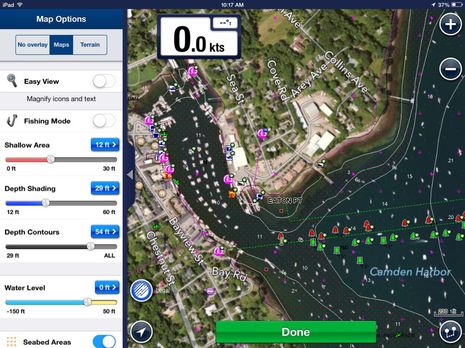
So here’s my Marine US HD app now upgraded to 7.0 so I can view NOAA data if I want. While it’s not surprising that the Navionics charts have a lot more features available — like satellite photo overlay, Community Edits, excellent tide forecasting, and more — a little further down I’ll illustrate some of the many Boating app features that come free.
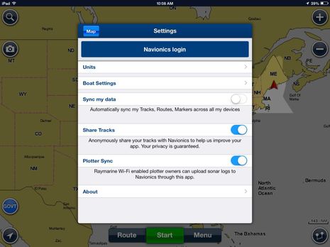
First, I want to note that both 7.0 apps include a newly revised Plotter Sync feature that I’m quite excited about, and that may also explain why Navionics is now giving away a perfectly usable charting app. As explained at the Miami Boat Show, Raymarine and Navionics are stepping up their app/MFD integration with a sync that will not only share routes and tracks (feature temporarily removed), but will also use the app and mobile device as a way station between Navionics servers and Ray MFDs. Fresh charts and Community Edits will go to the boat and if you’re willing, automatically collected soundings will go to Navionics. In other words, boaters using free Navionics Boating will conceivably help collect data that might eventually induce themselves and others to purchase Navionics charts and the added Freshest Data option that includes SonarCharts. It’s a clever scheme indeed, and the demos I saw suggested that what sounds like a complex synchronization will be super simple for the user.
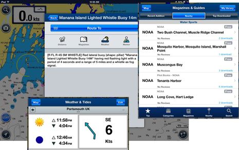
Here are some Navionics Boating app features that work even with free NOAA charts. Data like nav aid specifications is easy to access and read, the “Magazine & Guides” library includes NOAA Pilot information, and at least wind and Sun/Moon data is available worldwide. I also think that basic route making works pretty well, though I’ve become fond of the $5 Advanced Routing module that came out a while back. No company has been working on charting apps longer than Navionics and it shows, even in the free version.
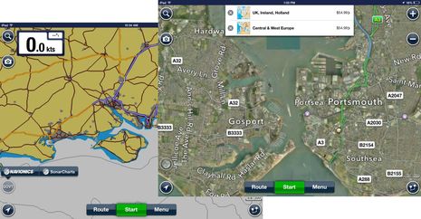
So, why was I looking up the weather in Portsmouth, England? I’m pleased to report that I’ll be visiting the Raymarine R&D center there next week. You can see in the screens below that even when using the free “Govt” charts in Navionics Boating, there’s still a somewhat useful base map available elsewhere. When I tried switching to Navionics charts, I was, of course, offered the opportunity to buy them, but could also get at Menu/Map Options to turn on the photo overlay. I’ve only messed with the new 7.0 app briefly; what goodies or issues can you find?
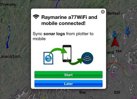
PS 5/31: Sonar log uploading is working for me, and it’s easy as pie. When I got onto the a77’s WiFi yesterday and opened Navionics Marine US HD, I was greeted with the message below. The app even walked me through where to find the button to enable sonar logging on the Ray MFD (running LightHouse II v10.34). When I did the same thing today, the app uploaded and processed the sonar logs it saw on the a77 to my iPad mini and when I got home it sent them off to Navionics with the promise that the resulting SonarCharts will be available in about a week. Apparently the sonar logs are automatically saved to the whatever card is in the MFD and can also be uploaded to Navionics via the Chart Installer you can download from their site. So you don’t need the app to contribute sonar data. But you do need either a Navionics+ card or the Freshest Data app option to see SonarCharts.


I would love Navionics to have
1) Active captain
2) Listen to AIS from my Vesper vision
3) Integrated log feature.
I am tyring Navplay and will see if that does the trick. But I can’t complain about Navionics. Just sailed from Argentina to Florida and used it often!! Never an issue.
I’m working on an article for my column on charting. That article has sent me diving through the Panbo archives. I came across this article and had to smile at how it has aged. It may have taken a few years (or more) but all of your wish list is now possible.
-Ben S.
My biggest complaint with using the NOAA charts is that for my area they are only available in raster format which is semi-useless for course-up navigation, unless you like to read upside-down text.
I have OpenCPN on a netbook which is stored in a Pelican case for emergency use if the main chart plotter fails.
It appears that it will be years before NOAA ENC vector charts will be available for Lake Champlain. Probably about the same time USCG there finally gets its first helicopter. Their SAR response time by air is about 3 hours now, not useful in 40° water.
I love the Navionics app.
The huge value that you only touched on in your note is the SonarCharts option.
It is essentially real-time high definition bathymetry and the more I use it, the more I find it invaluable. When you see the bottom contour differences between it and the “official” charts, it is pretty astounding.
I also like the current forecasting, and that the tool they use is in the same format as the tide forecasting. Learn one and you ‘get’ them all.
What kills me is I cannot get it on my Furuno Navnet 3D plotter. Any chance you can light a fire under someone for this Ben?
So I sit there in the pilothouse with thousands of dollars worth of plotter and monitors in front of me and before I do anything I reach for my iPad and look at what the $100 (that includes the SonarCharts subscription) app says.
Thanks, Mike! It’s nice that anyone can check out SonarCharts by zooming in on the Navionics WebApp and clicking the Sonar button:
http://www.navionics.com/en/webapp
I believe that most of the data in SonarCharts now is what Navionics used to call Fish N’ Chip. It’s a collection of high res bathymetry from many sources, some from NOAA, I think, but never brought into the official chart database. In fact, it may correlate to a fair degree with the hi-res bathy data that Furuno provides along with NavNet 3D charts.
At any rate, Navionics is adding user collected soundings data to the existing fishing data, but I don’t think much has been submitted yet because collecting it was complicated and tedious. But that may change bigtime with the advent of easy data collection on Raymarine gear and easy transfer via the Navionics app. I just gotting it working today; see PS above.
I downloaded the free Navionics app, and the free “Govt” charts, and used them off and on for the last two days while cruising the ICW. My first observation is that these charts are not the same as the free NOAA charts available via iNav-X for example. The Navionics charts are stripped of some important features such as marker numbers. And there is a few bugs. They crashed my iPad once, and locked it up on another occasion.
However, I am pleased that Navionics are offering both their app and these charts for free, since it gives anyone who may still not be convinced of the advantages of using an iPad for navigation, an opportunity to try it at no cost. Just so long as they understand that they will almost certainly want to download better charts.
So what does this offer the android tablet user that NOAA’s MyNOAACharts app and charts do not?
Ben, I feel I need to correct something from your article. The newly revised Plotter Sync does indeed introduce the ability to sync sonar logs direct to the Navionics servers. However, this has been at the expense of waypoint/route sync. As of version 7 of the Navionics apps, waypoints and routes no longer sync between the apps and Raymarine MFDs. This loss of functionality was not advertised in the updates, however when questioned Navionics have simply stated it is part of their new Plotter Sync feature. They also provide no assurances the waypoint/route sync feature will be reintroduced at any stage.
I would appreciate it if you could update your article to reflect this information, and join me in pressuring Navionics/Raymarine to reintroduce this feature as soon as possible.
Rich, I’m quite surprised by this, and I’ll certainly look into it. I presumed that route and waypoint syncing were of course included in the updated Plotter Sync function with Raymarine, but maybe not. I don’t see how adding sonar log or chart syncing could cause this, but there is the fact that Raymarine deeply changed their waypoint and routing formats and organization in LightHouse II.
If this feature got dropped, I sure wish Navionics had mentioned it in their big Miami press conference. But I doubt it’s permanent. I’m pretty sure that both Navionics and Raymarine want to support route syncing (like Garmin does 😉 and note that the feature just got added to Navico MFD’s:
http://www.navionics.com/en/wikis-and-stories/press-release-navionics-announces-expanded-chart-availability-and-connectivity
Rich, you are right that the route and waypoint syncing to Raymarine plotters has been removed from the Navionics 7.0 apps (and I edited entry to reflect). But it’s only temporary and wasn’t even planned until recently. Or at least that’s why Navionics says it didn’t mention the change at their Miami press event.
Apparently what happened was that they were getting increasing complaints about route syncing not working well with Raymarine gear, particularly networked MFDs. It was decided by both development teams that the feature needs a rebuild, but they didn’t have time for this release so out it went. My source at Navionics thinks it’s just a matter of weeks, maybe a few months at worse, but route syncing will be back in a more stable form, and it will allow the app user to send a new active route to the MFD system (like Garmin does).
If route syncing from the Navionics app is important to you, it might help to make your wishes known here or elsewhere. One thing that seemed more vivid than ever during the Raymarine visit is how very long the list of features to come (or be improved) is. And how hard it is to prioritize. Squeaky wheels often do get oiled sooner.
Ben, thanks for looking into this.
I’ve made my thoughts very well known to both Navionics and Raymarine through both emails and Facebook. I’ve also encouraged others to do the same. Unfortunately, both companies have repeatedly given me the canned response in relation to the “new and improved” Plotter Sync and they would not make any assurances as to whether route/waypoint syncing would return.
I’m glad you were able to get a more informed response from your source and I very much look forward to the feature coming back (I’m sticking with version 6 until it does, as planning routes on my iPad prior to syncing to the plotter is my primary use for the Navionics app).
So while I’m enjoying the new Navionics apps and + plotter charts, folks with older plotters may be frustrated. Like my friend Charlie Doane:
“Any ideas on how to get electronic charts for Nova Scotia that I can run on my 7-year-old Raymarine A65 plotter? Navionics tells me I need a used card, CF/11XG-2, from the distant past, 2009. There’s nothing on EBay or any other source I see online.
The idea that I have to junk a perfectly good $1,000-plus plotter and the cards I bought at the time, costing hundreds of dollars, in order to expand my range really is annoying.”
Anyone know where used Navionics CF cards get traded?
Would a Navionics Gold 2XG Gold Plus Canada and SE Alaska on the CF card format do the trick? I have ordered several chart cards from these guys and numerous marine items – so happy to make a call to check that it is not vapour ware. Cheers Dave
http://www.marine-deals.co.nz/navionics-cf-2xg-gold-plus-canada-and-se-alaska
Perhaps an update on the state of the nation re: Navionics and Raymarine is in order in light of the recent “re-release” of route/waypoint sync between the mobile app and Raymarine MFD’s.
My own experience is that despite having Platinum charts on my MFD and having paid for the mobile App, because my 1 year freshest data subscription is up, the mobile App won’t let me sync to my Raymarine C125. On the Raymarine C125 side I seemed to spend the whole summer pressing “do not show this again” to the nag screen that comes up because my subscription renewal date is passed. Very frustrating.
I imagine they will work through these issues but the timing was terrible given the boating season is now almost done for us Canadians.
The new Raymarine auto-routing feature in Lighthouse 11 is cool. I haven’t tested it extensively but it seemed to work the other day when I tried a couple of samples. The only thing which would be nice would be to specify a minimum distance from hazards(shallow water) and not just a minimum depth. Not to be relied on of course, but it does speed up data entry on the MFD directly.
I purchased the Navionics North America and Canada Navigation with Lakes. In October, 2014 it quit working. I reinstalled the app and it still would not work. I contacted Navionics and got the run around. Now, all of there boating apps have been removed from Google Play. Seems they are hyping a new app at a much inflated price tag. If they want to sell another app at a higher price, that’s fine. But I purchased an app without any time constraints and I expect it to continue to work. I Would never buy another app from Navionics. They discontinued my paid for app with no notice and without any offer of a discount on their new app. I would recommend NOT BUYING ANYTHING FROM NAVIONICS!
JB, You certainly shouldn’t have to buy a new version of the Navionics app but I don’t think you have to. When I read your comment yesterday, I opened up my copy of Navionics US & Canada — which I purchased a couple of years ago — and it’s been updated to version 4.1.2 and is running fine on a Nexus 7 running Android 4.4.3
Also my older U.S. & Canada app got upgraded for free with a one year subscription to Freshest Data and SonarCharts, which is a nice move Navionics made last summer for the iOS apps with v7.1. I discussed in the comments to this entry:
https://panbo.com/archives/2014/07/navionics_sonarcharts_now_via_sonarphone_or_gpx_file_plus_the_lowrance_autopilot.html
I do see that there are few Navionics app on Google Play right now but presume it’s because they’re transitioning to the Boating apps that you can get for free but buy charts within. The Boating Asia & Africa app that’s up now is date 10/23, and I bet the others will follow shortly.
More important, if you sign into Google Play and look in the “My Apps” section you’ll see whatever Navionics apps you’ve ever purchased and can download them to whatever Android device you want. I even see a copy of Navionics Marine US East that hasn’t been updated since April 2011.
If your Navionics app is that old, it is not getting updated but is still yours to use. But if you have a more recent Navionics app I think you’ll be happy to see that it’s been much improved. You just have to get running on your Android device again, which is hard to help with remotely.
Can you revisit Navionics? They are going subscription and ask you to download the latest version. With Garmin are the wheel, it would be nice to know the pricing plan.