
Navionics’ Platinum, photo maps
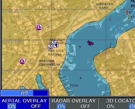
I’ve been getting requests to show more Platinum screens, so here’s one of what’s called Aerial Overlay. That means you can blend the regular vector charts with photo maps, which are straight down images that have been geopositioned so data (including your boat) can be plotted on them. Here the transparency of the photo map is set at 69% using the rotary knob on an Raymarine E120. Note how the photos improve your knowledge of what’s along the shore. Note too that the blending reveals descrepencies between the vector data and the photo map, a head’s up that one or the other is inaccurate. Platinum seems to include this resolution of photo maps for the whole U.S.; I understand the European version is lower res. Note too the camera icon, which shows you that there is also an “oblique” or “panoramic” photo available for this specific spot (wish we could all agree on nomenclature!). These are not geopositioned but do give you a useful perspective view of important inlets, marinas, etc. In Platinum they are quite high res (example coming).


Recent Panbo Comments