
Baron Quicklink, XM WxWorx weather goes global
XM Satellite Weather actually has nothing to do with this new product, but I mention it in the title because Baron Services is both the meteorological expertise behind XM Weather and the developers of the WxWorx software which can make that XM data accessible on a boat’s PC. The idea of the new Quicklink is to provide XM-WxWorx-like semi-real-time weather beyond the North America coverage area of XM’s satellites, and it looks like Baron is pulling a couple of rabbits out of the hat to do it…
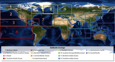
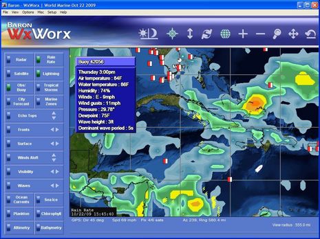
Note, for instance, the Nexrad-radar-like precipitation mapping on the Caribbean Sea image below, even though there are no radars covering most of that area. Called Rain Rate, Baron generates it globally based on computer modeling checked against ground truth. Note too the real-time lightning icons, also very valuable for storm cell avoidance, which Baron also has world wide. I didn’t even know that was possible. There are many more data set available, as suggested by the menu bar below, and it is all purportedly highly compressed, and selectable, so as to work over narrow bandwidth connections like an Iridium phone. While not yet shipping, the new service is pretty well explained at this Quicklink site, where you can also sign up for a coming prerelease software demo. Be warned, though, that the finished QuickLink will cost about $500 with a $100/month subscription.


PS: I haven’t checked into ClearPoint Weather recently, and it looks like their 2.0 version may be quite competitive with Quicklink,
https://panbo.com/archives/2007/11/clearpoint_weather_anybody_else_tried_it.html
As a user of offshore weather info collected using low bandwidth connections (sat phone), I was very interested in your post until I read “$500 with a $100/month subscription”. At that price point, Barons aren’t targetting leisure users with this service. Oh well.
Yes, this looks similiar to Clearpoint in that you had multi continent coverage, low bandwidth options, etc.
In regards to price, Clearpoint also seemed to be very focused on providing wind predictions that money can’t buy anywhere else short of personal direct access to a forecaster, that helped justify their price which I recall was equal or less than $100/month. The wind part was pitched to me as better than Weather Guru’s, and others. As most of us know the wind forecast in Sirius, XM, weather.com, NOAA, and others is really terrible both in direction and wind strength. Clearpoint was working on efforts to tie forecasts to wind truth as measured by sensors in the areas they cover.
Some of the best parts of the Clearpoint product for use in costal areas, like the doppler radar, requires higher bandwidth such as offered by wireless broadband and didn’t recover well when my Verizon EvDO connection reset and also was heavily delayed (eg. 20 minuted) compared to XM and Sirius (5 minutes) as part of controlling bandwidth which was not good enough for understanding t-storm cell movement unless collecting data for over 60 minutes, while 30 minutes was enough on XM and Sirius to get a good initial first view of the rain/storm pattern.
If you have not yet looked into the OCENS WeatherNet service – I highly encourage you to do so. OCENS has been addressing the bandwidth issues from the beginning as well as the costs via a pricing model that fits all budgets.
The WeatherNet service is only $99 per year!(plus downloads but those only run $.18 to a couple dollars per file and you are only billed for what you download) The WeatherNet service provides access to thousands of weather products spanning the globe, all designed to work with your low-bandwidth Iridium phones (or any other internet connection you might be able to grab). The focus here is on getting the data on-board – for any coverage area in the world – in your budget.
Once the files have been downloaded – OCENS has supporting viewer software for displaying and working with those files or the files that you get from any other source. For GRIB files there is GRIB Explorer. This is by far the most powerful GRIB reader out there – and very intuitive. This software is $199.
OCENS MetMapper software is a viewer for weather-fax charts, satellite images, animation images, text report, and more. This software is $169. It allows you to open various types of files, images, animations, and text, all on the same screen – can geo-reference the charts and allow you plot points and make notes right on the charts to help with your analysis.
So if you are looking for a lot of high quality weather data, or just a little, coastal or mid ocean, north pole, south pole or anywhere in-between, and at a price that you control – OCENS just may have the answer.
You will also find the WeatherNet service as part of Nobeltec’s Admiral software as well as part of Expedition, and Deckman. The GRIB data that you download via WeatherNet is standard GRIB 1 format so you can load it into any software that supports that format as well as the parameter that you downloaded.
Jeff – Totally agree and have been using Ocens stuff since it was first released. That being said, I’m also interested in getting higher resolution GRIBs producing using models other than GFS(?).
Ben, The ligthning data is probably collected from the VLF World-Wide Lightning Location Network which uses VLF stations around teh world to build real time lightning maps.