
Is it true news that “NOAA wants to stop making NOAA charts”?
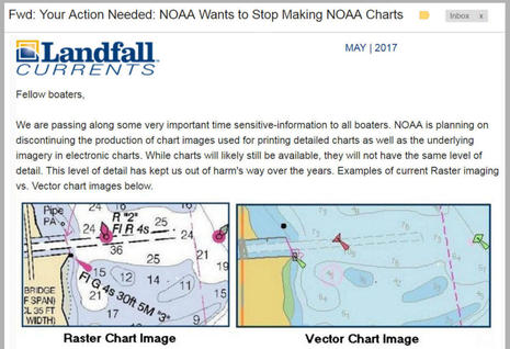
I’m a longtime fan of Landfall Navigation and I’m sure their intentions were good when they emailed this call to action Friday afternoon. But please don’t file a comment or call your congressman without looking deeper into the “news” that NOAA plans to discontinue all (paper-chart-like) raster files. In my read the end of rasters is only a far future possibility suggested in a recently published National Charting Plan that has some real meat (discussed below), and I’d be flabbergasted if it happened soon, or ever at the expense of important chart detail. Let’s judge NOAA on facts, not fearful conjecture…