Category: Charts

CE  & ACC, great but not enough! Part 1 2

CE & ACC, great but not enough! Part 1

Rose Point CE and ACC cPanbo.jpg

One thing I’ve always liked about Coastal Explorer is the way it handles points of interest (POI) information.  It includes a vast, searchable gazetteer, along with coast pilot info that gets listed and icon-located when you’re checking out a harbor (“places” tab).  Plus it integrates Panoramio community photos if you want and Maptech marine facilities and port photos if you have them. (CE 2009 is not sold as Maptech Chart Navigator Pro, though CNP, which is actually CE version 1, is still being sold as “new” software.)  You can see in the Options box above how Rose Point is working on an automatically synchronized Community Guide Book idea that has terrific potential.  But, whoa, check out the new “Subscription” options that will appear in an CE update very soon.  Rose Point has struck an interesting deal with the Atlantic Cruising Club guide folks, and thus CE users will get free partial ACC marina listings — like the Wayfarer data above — for those guide areas shown.  They’ll also get a neat way to integrate complete ACC guides into CE…

Tim Thurston, map maker extraordinaire 13

Tim Thurston, map maker extraordinaire

Tim_Thurston_Lake_Megunticook_cPanbo.JPG

Tim Thurston earned that grin.  We were out on Lake Megunticook last week, randomly comparing the digital map I helped Navionics make last fall with the survey work Tim did for his little Maine Lake Charts company at about the same time.  And while that little islet in the background is on the beautifull MLC paper map Tim made, and on that Garmin Etrex he managed to put his digital data on, it was completely missing from the Navionics map!  While this is a shallow and somewhat out-of-the-way spot I steered us to — and both maps are way, way better than what was available right until to this summer — I tend to think that Tim got the details better.  Unfortunately boater can’t make best use of those details just yet…

C-Map is back, in many dimensions 4

C-Map is back, in many dimensions

C-Map4D_3D.JPG

Actually C-Map never went away. But it has been fairly quiet since becoming part of Jeppesen Marine in early 2007.  Oh there was scuttlebutt about how Jeppesen resources meant vastly improved data acquisition and distribution capabilities, not to mention evidence of zero error tolerance. And C-Map MaxPro cartography came to Nobeltec charting, though sadly many remember the event more for a dumb raster chart policy than, say, MaxPro’s slick Quick Sync data updating.  Meanwhile, arch rival Navionics worked its way into more and more displays.  But things change, as certainly happened on Tuesday when Raymarine previewed E Wides, which will come C-Map preloaded and also support a new format C-Map calls 4D

Panbo punts, Garmin grieves 16

Panbo punts, Garmin grieves

This entry’s title is not about cause and effect; my wind sensor testing may go incomplete, but that has nothing to do with Garmin’s chart problem.  And while I had a good time on...

A57, iPhone, & HDS-10 — Navionics everywhere 1

A57, iPhone, & HDS-10 — Navionics everywhere

Navionics_charts_on_Li'l_Gizmo_cPanbo.JPG

The photo isn’t fair, because the shooter (me) is reflected in the Raymarine A57D‘s screen and the iPhone is in an Otter Box which includes a screen protector that muted its display in a way I don’t notice in normal use.  But there’s some truth here, too; the screen on the Lowrance HDS 10 has been bright, crisp, and completely readable in all light conditions so far experienced on Li’l Gizmo’s completely exposed helm, whereas the other two have sometimes been quite hard to read.  Another truth is…

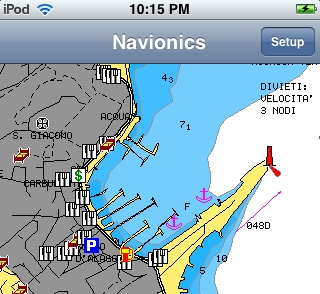
iPhone/Touch nav, yet more news 14

iPhone/Touch nav, yet more news

I don’t usually write about rebates and sales, but 90% off!?!  Navionics not only launched version 2.0 of its Mobile app yesterday, it’s slashing prices. Here’s the press release, and note above how the...

Fugawi & iNavX & Navionics & ??, the pieces come together 15

Fugawi & iNavX & Navionics & ??, the pieces come together

iNavX new chart n map choices2.jpg

Wow, isn’t an interesting crowd of chart, map, and data suppliers gathering rapidly around the iPhone/multi-other-platform X-Traverse service?  I recently discussed the velocity of this and other iPhone-related developements, but was still surprised to learn today that Navionics is officially on board (Americas charts and U.S. Hotmaps available now, the rest of the world portfolio coming “in the next couple weeks”), Hilton’s Realtime-Navigator fishing overlays will go up on X-Traverse in May, and that “agreements are in place with several other chart manufacturers to bring expanded coverage and choice (raster or vector).”