Category: Charts

Autorouting: Navionics new Dock-to-Dock kicks it up a big notch 16

Autorouting: Navionics new Dock-to-Dock kicks it up a big notch

Navionics_Dock-to-Dock_AR_Gloucester_cPanbo.jpg
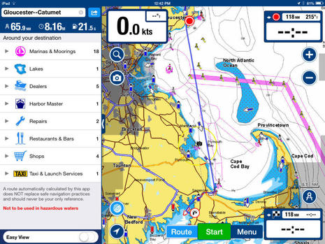
Let’s end 2015 with some new technology that will really make a difference, I think. It’s Navionics’ new Dock-to-dock autorouting system, and it may not be getting the recognition it deserves because Navionics already offered autorouting that was only marginally useful (like the others I’ve tried). Dock-to-dock is not perfect, but it still strikes me as a quantum leap improvement that many boaters are going to appreciate…

Garmin 2016: Quickdraw sonar charting, smaller Panoptix, Striker, and lots of CHIRP 9

Garmin 2016: Quickdraw sonar charting, smaller Panoptix, Striker, and lots of CHIRP

Garmin_Quickdraw_aPanbo.jpgGarmin put up a Marine 2016 site this morning and one thing many current Garmin owners will be excited about is the Quickdraw Contours sonar charting that will come to many current Garmin displays in January. Yup, you’re going to be able to easily collect soundings as you cruise, sail or fish and, if you want, you can watch the resulting high def sonar chart materialize in your wake, as suggested above. Quickdraw is no surprise given the tussle over Navionics SonarCharts for Garmin, but naturally Garmin added some special sauce…

TBF: NV Cuba, YB3 free, Furuno GP1x70F steals, BT VHF, and Sailing A 5

TBF: NV Cuba, YB3 free, Furuno GP1x70F steals, BT VHF, and Sailing A

TBF_logo_Panbo.jpgApologies in advance to Panbo readers who’ve complained about too many acronyms, because I’m adding a new one. The idea of Tidbit Friday (TBF) is to create an entry type where I can share some of the juicy morsels I often come across as I indulge my endless appetite for marine electronics and the wider world of boating. You won’t see one every Friday, but when I started listing possible recent subjects, it sure got long in a hurry. There’s lots I can do with one image and a paragraph…

On The Water ICW ChartGuides, more great work from Mark & Diana Doyle 8

On The Water ICW ChartGuides, more great work from Mark & Diana Doyle

OTW_ChartGuide_ICW_vol1_ed1_aPanbo.JPGMy expectations for the recently announced On The Water ChartGuides were high, but darn if checking out a whole 120 page review copy didn’t blow me away (and I’m already familiar with most of the Intracoastal Waterway that Volume 1 covers). The two new ChartGuides are also remarkably inexpensive in print or electronic formats, just like OTW’s other ICW guides. My only complaint? The Doyles are such skilled and prolific communicators that I feel like a piker!

The paper chart, still the best? 8

The paper chart, still the best?

Working_on_a_training_chart_cPanbo.jpg

It’s true that I don’t navigate on paper charts anymore, but I appreciate them and use their electronic equivalent more than ever. One reason is what I learned last January while preparing for a TrawlerFest seminar called “Soup to Nuts Navigation” (which I’m reformulating right now for the new Cruising Boat Expo here in Essex, CT). The other is having just run up from North Carolina — including the entire New Jersey ICW, which can’t fit much more boat than Gizmo — with just about every chart type and brand in view. I think we would have had more trouble than we did because my mate and I learned navigation starting with paper charts and we referenced the equivalent heavily…

Raymarine Chart Store, the Lighthouse format go international 16

Raymarine Chart Store, the Lighthouse format go international

Raymarine_Chart_Store_opening_3-15_cPanbo.jpg

I heard in Miami that the online Raymarine Chart Store would soon open, but I had no idea how well stocked the virtual shelves would be. It was great when Ray enabled its own Lighthouse raster and vector chart format a year ago even though they only duplicated NOAA’s entire free coverage of US coastal waters. Now there are more free charts available — for other nations that also give their data away, like Brazil and New Zealand — as well as access to an interesting array of commercial charts…

Shouldn’t our community sourced marine data be open to all developers? 48

Shouldn’t our community sourced marine data be open to all developers?

OpenSeaMap_Depth_Data_call_aPanbo.jpg

I’ve been cogitating a lot about crowdsourced depth data lately, including the realization that “community sourced” is a better term. Whatever it’s called, Navionics in particular has made it wonderfully easy to collect and share sonar files and especially wow with the Vexilar integration. But the business stakes are high and thus we have the frustration of Navionics and Garmin butting heads. Upon further contemplation, a wistful thought from that last entry — “Wouldn’t it be great if we could upload our data to some service that would make it available to any chart developer?” — seems not only important to avoiding further messes and helping this technology proliferate, but also quite possible…

MIBS 2015: Raymarine, Icom, Lowrance, B&G, FLIR, Blue Sea and drones 8

MIBS 2015: Raymarine, Icom, Lowrance, B&G, FLIR, Blue Sea and drones

MIBS2015_Raymarine_CP370_install_cPanbo.jpg

“Black is the new gray,” say the folks at Raymarine, and so it is with the three new CPx70 sonar modules which were introduced in Miami. They’ll replace the existing blackbox fishfinders but not the CP100 and 200 CHIRP Down-or-Side-Vision and sonar combos designed for shallower depths and structure imaging. So by contrast the 600-foot-max-depth CP100 also installed on the demo boat above highlights the beefiness of the new base CP370 model, which is actually the bottom of the line with its traditional dual 50KHz and 200 KHz fixed frequencies, 1,000W of power and purported depth range of 5,000 feet. The performance enhancements seem subtle but multiple…

Lessons of Vestas Volvo wreck, but what about the C-Map Grounding Alarm & similar? 44

Lessons of Vestas Volvo wreck, but what about the C-Map Grounding Alarm & similar?

Vestas_jibing_after_grounding_aPanbo.jpg

The fixed camera on the stern of Vestas Wind captured the worst possible unintended jibe. That’s when you’re blast reaching along at 19 knots through a tropical offshore night but then your Volvo Ocean 65 suddenly smashes its way up onto a reef shearing off the rudders and spinning 180° as waves and wind take total control. That is a frightened and nearly naked man beyond the limp main sheet and when watching the video you too may utter involuntary curses. No one was hurt, though, and the crew has been frank about the mistakes made. This has led to some useful conversations about the dangers of electronic charting, but it also reminded me of an uncommon electronic charting feature that might have prevented this shipwreck…

Navionics SonarCharts, now via SonarPhone or GPX file, plus the Lowrance autopilot 25

Navionics SonarCharts, now via SonarPhone or GPX file, plus the Lowrance autopilot

Navionics_Vexilar_iPad_app_aPanbo.jpgWow. Combining the Navionics Boating apps and the Vexilar SonarPhone WiFi fishfinder seems like an obvious developement now, but there are so many marine electronics integration possibilities these days that even the ripe low-hanging fruit can be surprising. Announced yesterday at ICAST (PDF here) and available for iPhone/iPad in August (and Android later), the combined Navionics SonarPhone app means that a small boater can have a fairly sophisticated plotter/fishfinder for about $200, phone or tablet not included (and note the issue of screen visibility in an open boat). I was impressed with the SonarPhone bobber-style T-Pod in April and suspect that SP200 T-Box small boat model works even better. And there’s more: The user of this system can very easily contribute their sonar logs to Navionics’ SonarChart collection, which they can access (along with chart updates) with an additional $25 Navionics+ annual subscription.