Category: Navigation

Raymarine LightHouse II, the paper chart lives on 21

Raymarine LightHouse II, the paper chart lives on

Raymarine_LightHouse_II_w_NOAA_raster_chart_cPanbo.jpg
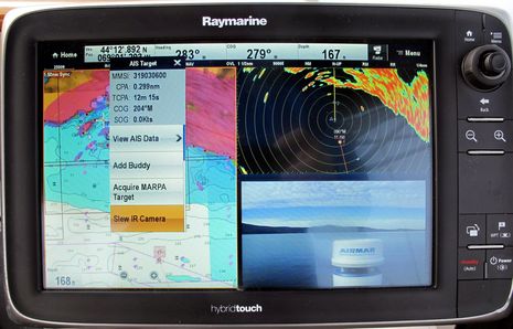
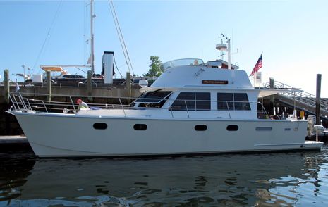
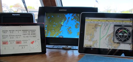
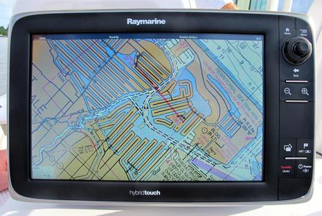
Isn’t it interesting that just after we learned that NOAA will no longer print traditional paper charts, Raymarine announced that all its current plotters will soon be able to use the digitized ‘raster’ equivalent of those same NOAA charts? The “completely redesigned LightHouse II” software that will make this entirely free new feature happen is due out in December, but I got on the water with a beta version last week. I was impressed with how well the raster charts looked and how well they panned and zoomed, even in beta, and there’s much more to like about LightHouse II…

FLIR M-Series nav cam test, Raymarine integration appreciated! 12

FLIR M-Series nav cam test, Raymarine integration appreciated!

FLIR_M-618CS_test_Slew-to-Cue_cPanbo.jpgI’ve long thought that the usefulness of a navigation camera would increase significantly with tight integration to a boat’s principal navigation system, and now I’m convinced. When I redid Gizmo’s antenna mast last spring, I got to top it off with a powerful FLIR M-618CS dual camera system that was sometimes very handy as I cruised up the coast. But when I finally got around to integrating it with the Raymarine e-127 above, its safety value took a quantum leap. While it’s obvious from the lower-right camera window that this particular test day was very clear, also obvious to me was the camera system’s potential when I can make it quickly pan and tilt to any spot on the chart screen, on which it will stay locked no matter how Gizmo manuevers and — in the case of MARPA and AIS targets — regardless of how the target moves…

Improved current data? Let the IHO know you care. 7

Improved current data? Let the IHO know you care.

IHO_Surface_Current_Survey_page_cPanbo.jpgMaybe you too have an opinion about how predicted currents should be overlaid on electronic charts?  Well, the International Hydrographic Organization (IHO) is developing an S-100 specification for “the delivery and presentation of navigationally significant surface currents” and right now they’re running a online survey of all interested parties. What waters do you care about (coastal for me)? What prediction frequency would you like? Are you willing to pay? How should the data look? And more…

NMEA 0183 lives: Digital Yacht GP150 DualNav & Furuno IF-NMEA2K2 Converter 12

NMEA 0183 lives: Digital Yacht GP150 DualNav & Furuno IF-NMEA2K2 Converter

Digital_Yacht_GPS_150_Dualnav.jpgI’ll write soon with NMEA Conference details of the futuristic (and unfinished) NMEA OneNet standard, but I also left San Diego with the strong impression that the good old NMEA 0183 standard is still very much alive. One interesting example is the new Digital Yacht GPS 150 DualNav, which earns its last name for its ability to receive more than one set of positioning satellites at once — already active GPS and GLONASS in particular, more coming — and to then deliver more accurate L/L, COG & SOG than can be gleaned from just one GNSS system.

IBEX13 #2: Simrad NSO evo2, a new multi-touch glass helm architecture 11

IBEX13 #2: Simrad NSO evo2, a new multi-touch glass helm architecture

Simrad_NSO_evo2_dual_video_slide.jpgWhile Simrad may the last of the Big Four to introduce a high-performance multi-touch glass bridge system, it seems like they’ve added at least one significant twist to the concept. The new NSO evo2 black box contains two independent main processors which can drive two independent displays. The brochure claims that this architecture gives you “the freedom to view and control your onboard systems more easily while making every dual station installation or larger networked system simple and much more cost effective.”  It’s a claim that I tentatively buy…

IBEX13 #1: Garmin/VP Glass Cockpit vs Raymarine ECI-100 4

IBEX13 #1: Garmin/VP Glass Cockpit vs Raymarine ECI-100

Volvo_Penta_Glass_Helm_IBEX_cPanbo.jpgI just spent five full days at IBEX 2013 — as press guy, Innovation Awards judge, and NMEA seminar presenter — and I’m heading home with LOTS to write about. I’ll start with the deep integration Garmin and Volvo Penta put into the handsome Glass Cockpit system I was checking out above, and how smartly Raymarine has responded to this market-share threat. In my view it’s happy story about how competition and technology are making boating better…

Brian’s P47: “Picking a Partner” 7

Brian’s P47: “Picking a Partner”

Maine_Cat_P47_Audrey_Louisa_cPanbo.jpgA handsome addittion to Camden Harbor recently has been the latest launch of the power catamaran design that was almost Gizmo, and darned if it doesn’t have a certain gizmological flare. Check the high-low combination of solid state and magnetron radars, for instance. In fact, the gadget-loving owner, Brian Strong, is a regular Panbo reader and he wrote up an interesting explanation of his electronics choices…

WiFi MFD’s, Navico GoFree promises more than met 36

WiFi MFD’s, Navico GoFree promises more than met

Simrad_GoFree_in_action_cPanbo.jpgAfter Raymarine and Furuno introduced multifunction displays with WiFi built-in and apps that could mirror and even control the MFD screen on an iPad or Android tablet — a great idea that caught on quickly — I was frankly a dite dubious when various Navico folks said that they had an even better idea. Eventually, though, we got to discuss the WiFi1, their MFD network hotspot, and then the whole multi-tier GoFree concept.  It’s a complicated concept largely because it’s so ambitious — for instance supporting both Navico screen control apps and multiple third party apps like the ones seen above — but it seems to me that GoFree is now doing even more than Navico promised, and there’s virtually no limit to where it’s headed…

GPS spoofing, will we ever learn? 32

GPS spoofing, will we ever learn?

GPS_spoofing_superyacht_courtesty_University_of_Texas_Austin.jpgHat’s off to Professor Todd Humphreys and his grad students for not only demonstrating that GPS spoofing is possible but for doing so in such a dramatic fashion that they got the whole media world chattering about it.  For instance, Fox News led their story with “The world’s GPS system is vulnerable to hackers or terrorists who could use it to hijack ships — even commercial airliners, according to a frightening new study that exposes a huge potential hole in national security.”  While I think that’s an overheated conclusion, I suspect that we may need a even greater scare to finally build out a secondary form of civilian electronic position fixing…