Category: Wireless & Apps
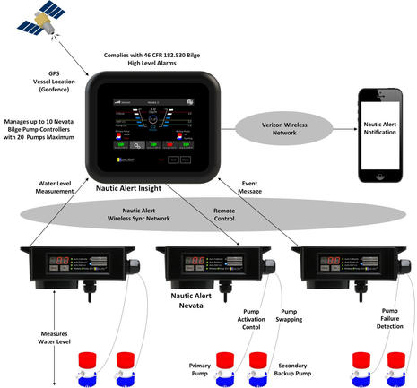
While my boat thankfully doesn’t need six bilge pumps like the system above, four months of serious testing has left me deeply impressed with the Nautic Alert bilge, battery and GPS precision sensor platform. Yes, it also manages one pump or many — probably better than any us ever will — and it clearly informs a skipper of problems whether you’re on board or off. Finally, Nautic Alert regularly assures me that all is well, and it’s ripe for expansion. I think I’m in love…
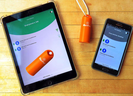
Does it make sense to use smartphones and tablets for a man overboard alarm and recovery system? I can testify that the first reaction of Sail magazine’s Pittman Innovation Award judges was skepticism. Nonetheless we found PanPan’s CrewWatcher so well thought out and potentially so useful that we gave it an award in the safety category, and then an independent second set of judges picked it for the Overall Winner. And truth be told, the finished CrewWatcher personal beacons and apps don’t actually exist yet!
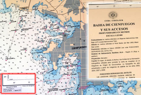
Pardon my photography, but the point is that many detailed, up-to-date, and well-crafted official paper charts of Cuba do exist. Unfortunately, they’re not easy to own and the good work of the Cuban hydrographic service is also not yet fully available in any electronic form. In fact, many “current” electronic Cuba charts are based on shockingly old data with substantial chunks of critical cruising detail missing. But visiting boaters do have at least one good current chart choice – GeoCuba is moving into the modern world, and the back story reveals chart issues every navigator should understand, with a Cuban twist…
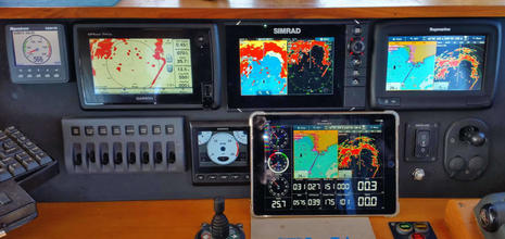
Hey, those are all solid-state radomes showing on the 7-inch displays at Gizmo’s lower helm, and you’d see a fourth one running on the flybridge. Comparative testing is underway, but today I’m going to write about the rather amazing WilhelmSK app running on the iPad above. It is not only mirroring the Raymarine a77 screen, touch control included, but also neatly displaying lots of NMEA sensor data that’s been converted to the app-friendly Signal K protocol, thanks to Digital Yacht’s iKommunicate gateway. In my opinion, WilhelmSK is a terrific early example of Signal K’s potential and also a testament to Raymarine’s powerful WiFi strategy…
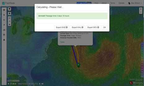
If you’re looking for a real getaway this morning, or even just an online distraction, FastSeas.com can help. It’s also a testament to how much goodness a smart boater/coder can create for his or her fellow mariners these days. And while FastSeas is primarily an online weather routing service for sailors embarking on ocean passages, it’s easy and flexible enough that even a coastal power cruiser can benefit…
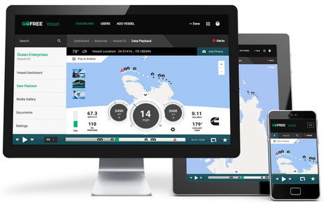
While off-boat monitoring was already getting better and more competitive, finally one of the big four marine electronics brands is about to join the fray. Navico’s GoFree Connected Vessel concept is not just important because it will be marketed and serviced worldwide, but also because the development team took the time to think out a truly comprehensive system that can potentially serve a wide variety of boaters in multiple ways. Meanwhile team Siren Marine has been building on their years of remote monitoring, tracking and control experience and will soon announce a series of second-generation MTC products that sound exciting. This entry will take a preliminary look at both these systems and I’ll soon share testing results on two more…
That’s very good radar imagery in my experience, especially given that it’s the fully automated output of a relatively small and affordable radome which can be super easy to install. Note, for instance, how well it’s separating the moored boats in Camden’s recently discussed Outer Harbor and thus usefully revealing the channel into the Inner Harbor (that many visiting boats have trouble finding even in clear daylight). I also got to see how well Raymarine navigation networks can handle dual radar scanners and how sophisticated their WiFi has become. And finally I hope to spank Ray about its annoyingly overprotective MARPA alarms (though that situation could be easily fixed in software ;-)…
The multiple layers of Garmin wireless communications going on above may seem crazy, but they all work well and have endless practical and/or fun applications around a boat. Normally, for instance, it would take two people to align a fixed boat camera, plus running power and video cables. But I simply climbed up Gizmo’s mast, mounted a Virb XE with an adhesive base, and aligned it using the free Garmin Helm app on my phone to see the Virb video screen running on the flybridge GPSmap 7612. It took mere minutes to get a masthead view at my helm, and while mounting the gWind sensor required tools, it too is completely wireless. Garmin is blazing several worthy wireless trails…
I’ve long felt that the DeLorme inReach is a valuable safety and communications tool for boats that sometimes go beyond reliable cellular (and/or VHF) contact with friends, families and rescue centers. But one gripe for skippers hoping to use an inReach as their only offshore communications device was the lack of weather forecasting. There were some necessarily crude third party solutions, but now DeLorme itself is offering easy-to-use and understand forecasts, both marine and terrestrial. I’ve just been testing this and many other inReach features in Cuba, though the legality of taking a satellite messenger/tracker there is uncertain…
The Boat Beacon app running on the iPhone screen above looks like a fairly ordinary AIS target display app that can also show your own vessel. In this specific example your 28-foot sailboat is plotted on center as you head south at 5 knots into the Solent with the ship Morning Calm overtaking you to starboard. But, hey, it’s pitch dark, the iPhone has a Flir One thermal camera attached, and Boat Beacon’s “Live View” augmented reality feature can now make use of this night vision device…