
Bent props 3, pictures by Garmin
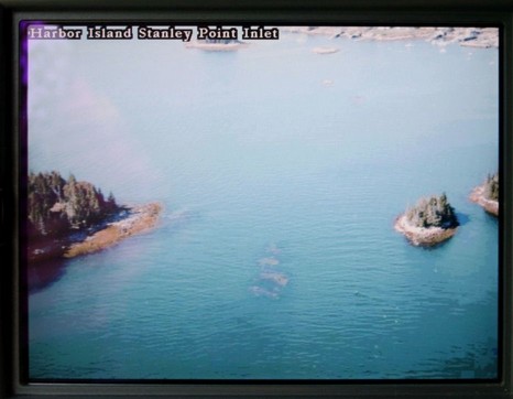
I promise I’ll stop writing about this ledge soon! But it does turn out that Garmin’s optional BlueChart G2 cards, first discussed in May, look good in terms of the great Burnt Coat Harbor bent prop incident. That is the guilty ledge just showing in this photo, taken at approximately mid tide; you can even make out the Can right (east) of it, especially nearer full resolution. Note too the trees on the little islands, a helpful detail that the Cruising Guide chose to emphasize in its sketch chart. Below you can see how the photo icon shows this shot’s view angle. Notice the multitude of photo icons! There’s also a straight down of this same ledge, a view from the north, several pulled back views of the whole channel, something like 12 pictures all together. By contrast, neither Maptech nor C-Map Max has any panoramic photos of this harbor, and Navionics Platinum has 3, but much more pulled back. Could I have missed a photo? You bet; no one seems to have the perfect photo interface yet, and with such a large inventory, Garmin has further to go than most. They’re working on it; the improved icon just arrived in a recent release. Mind you that Garmin’s cards are fairly pricey (especially considering that users already have the G2 charts themselves build in), but I do believe them when they say they’ve spent heavily on helicopter photography.

PS Speaking of pictures/maps, meant to mention how smartly the New York Times treated Navman’s iCN 750. Also, thanks, Bob, for pointing out the Google Maps version of the ledge, also Live Local’s, and most especially the super hi-res Bird’s Eye view of your (muddy) home waters (I found the amazing roller coaster marina area). If you haven’t seen Bird’s Eye photo mapping before, this is an excellent location to check it out.


Most of us don’t have this on our boats, but Google Maps satellite view shows it very well also.
http://www.google.com/maphp?hl=en&q=&ie=UTF8&om=1&ll=44.13248,-68.435147&spn=0.004605,0.007446&t=k
I am sure Google Earth is just as good. Microsoft’s Live.local.com is not quite as clear:
http://local.live.com/default.aspx?v=2&cp=44.13238~-68.43519&style=h&lvl=17
When Microsoft’s Local.live service has the “Bird’s Eye” available, you can really pick out some neat stuff. Here is range near my boating area:
http://local.live.com/default.aspx?v=2&cp=qxdcb1836mn9&style=o&lvl=2&scene=2364206