
Big storm, how about a contest?
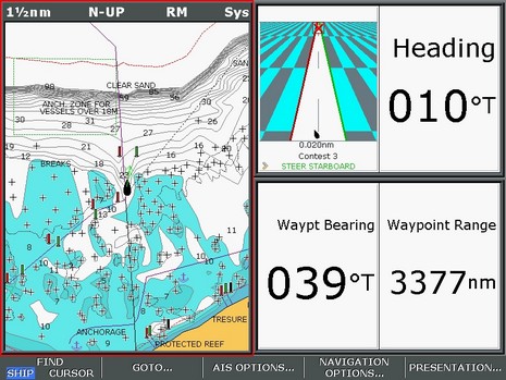
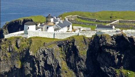
Whereas many of us are hunkering down for a monster low that’s bulling its way up the East Coast (gusts to 70 knots predicted here tomorrow!), another PMY navigation/photo contest may be in order. Above is the Raymarine E screen that’s printed on the inside back page of the March issue, and below is the boat’s waypoint, as shown in a photo from Marinas.com. Where is the lighthouse? And, for extra points, what is the boat’s present location. As before, please submit answers by email, not comments. By the way, I think this one is much harder for Google jockies to figure out, but nonetheless the real contest (with real prizes, but now closed) had quite a few correct answers. How’d they do it?


To all that are trying to solve this puzzle, the best of luck to you.
Respecting Ben’s wishes I will not say how I found the Light House, but a heavy dose of Dumb Luck was involved, based upon an incorrect hunch.
Ben was correct that Google Earth is not going to get you there. That is the clevor part of his puzzle I thought.
I could only get within 20 NM of the starting point, I would be curious to know if anyone found the exact starting point and how.
-Mark Read
mark at goreads dot com
Ben,
(after a week or so) Could you tell us how this was solved ?
This has gotten interesting! So far Bob Hinden, Pat Harman, and Roger Bingham have figured out the light house location just by guessing the general location and searching around. Both Mark Read and Fred Street figured that out, and got the starting point, but they did it by working backwards. My hope was that someone could figure out the general starting point from the geography shown on the little chart scrap, then perfect the location using local charts, then use the bearing and range to get the light house.
BUT now I’m realizing all the issues with Great Circle courses. The Raymarine calculates a great circle range and bearing. (So reciprocals may not work!) It’s very interesting how various charting programs and plotters handle a very long ocean leg like this; so far Nobeltec is the winner by far. More to come.
Cracked the location but went adrift on bearing and distance. May have finished up within 200nm!!