
Heywhatsthat, more fun with maps

Where is this bubbling geographic/Internet stew going to take us (like EarthNC), and, in particular, what the heck else is being created nearly under my nose (like ActiveCaptain)? The latest is a rather amazing service created by one Michael Kosowsky out in the Lincolnville hills west of Panbo HQ. It began with Michael wondering what distant bumps he was seeing from his yard and now–much programming later–he’s inventor/proprietor of Hey, what’s that. Check it out. Right off the bat you’ll see what’s what from Mt. Battie, which happens to be where I took the header photo of Camden Harbor above. You’ll see it centered in Google Maps with each visible peak marked by an icon, along with a panorama view above and a list of the spots to the right, each interactively clickable. But you’ve just gotten started.
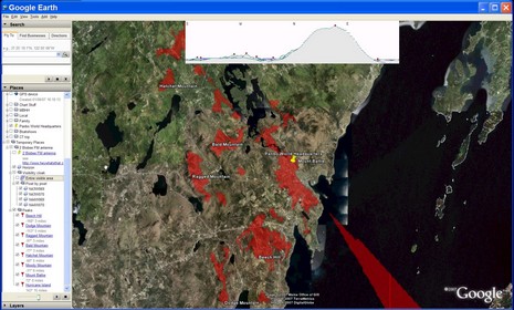
Select a high view you’re interested in and Michael’s server will do some magic mixing of its satellite altimetry and gazetteer databases for you. I tried one of my favorite Bay lookouts, Butter Island (above, and bigger here), and the site’s calculations are very close to reality. You can see I also enabled the “Visibility Cloak” (aka view shed). And you can overlay conventional contour lines (never seen before on Google Maps; correction: see EarthTools, which also does twilights), get a profile of a path, and more (check the FAQ). And you can take most of the functionality into Google Earth, as I have below (bigger here ), using it to see what a line-of-sight antenna on my roof can see (not a lot as I’m right in Battie’s lap on an already bumpy coast).
Hey, what’s that is quite an accomplishment as you’ll pick up in these enthusiastic reviews, and especially by watching Michael’s presentation at the Googleplex (yes, they invited him out). And, while not critical to navigation, this is the kind of added cartography that cruisers like me really appreciate. So what Michael wants to know is if there is enough interest amongst boaters to generate a little income? Businesses willing to sponsor panoramas of a certain geographic area? Boaters willing to, say, pay a little to download peak POIs that might display on Garmin’s slick 3D screens (which I showed him, and the new developer tools suggest is possible). Your thoughts?


Great Post
LOL, I just entered Lima, OH where I lived for nine years. It was in the Great Black Swamp – no elevation yielding of course, no results.