Category: AIS

AIS over NMEA 2000, the shame sheet! 86

AIS over NMEA 2000, the shame sheet!

Em-Trak_B100_N2K_AIS_on_Raymarine_i70_cPanbo.jpg

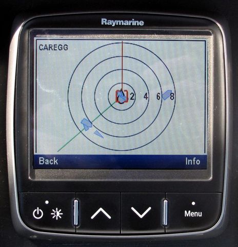
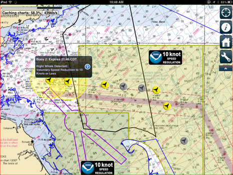
It was a beautiful weekend in Maine, and we deserved one, but sorry to report that there were sighs and curses of surprise and disappointment emanating from the good vessel Gizmo. I may be late with this year’s (way over the top 😉 electronics installations, but that’s what Gizmo is about, and I was looking forward to seeing how a new-to-me Em-Trak B100 Class B AIS transponder would work with a wide variety of displays that could use its NMEA 2000 output. As discussed here last June, the B100 is a compact, feature-rich, affordable transponder, especially compared to the others with N2K output. And while there was a glitch in early implementations of AIS over NMEA 2000, I had presumed that the major manufacturers involved had worked that out. Damn it, I was wrong…

AIShub, how you too can put AIS targets online 25

AIShub, how you too can put AIS targets online

AIS_Dispatcher_with_Vessel_Finder_site_cPanbo.jpg

At the end of Wednesday’s discussion about cell-based mAIS — which only works via the Internet instead of direct VHF radio transmissions — I mentioned how I’d set up a real AIS receiver in my lab to forward real AIS target info to those same Internet services. In fact most all the actual AIS targets shown in those screen shots came through my basement. The set up turned out to be very easy and cost nothing as I already had an AIS receiver, a computer, and an Internet connection. The key is the free program AISdispatcher seen in the foreground above, which is offered by AIS Hub data sharing center. That’s their Web site in the background, showing the data I’m contributing along with that of other volunteer stations. But there are lots of holes in the coverage and I’m hoping that more coastal residents and particularly marine businesses will volunteer, and I think that the new mAIS concept could make the effort especially worthwhile… 

Boat Beacon & MarineTraffic mAIS, yipee or yike? 27

Boat Beacon & MarineTraffic mAIS, yipee or yike?

Boat_Beacon_app_test_cPanbo.jpg

At first Boat Beacon may look like yet another iPad or iPhone app for viewing online AIS tracking services like ShipFinder, but in fact it’s a very new and slightly disconcerting form of AIS transponder. In other words that “Panbo BoatBeaconTest” target seen above is not the test transponder I sometimes run in the lab but simply my iPad running Boat Beacon and using its online connection to send my position, MMSI, and “boat” data to a central server where it’s also getting the regular AIS data for those various vessels in the Bay. The concept doesn’t really have a name yet — except maybe for mobile AIS or mAIS, as I’ll get to — but I think it’s going be huge, and also confusing… 

The Aegean loss, would AIS have helped? 23

The Aegean loss, would AIS have helped?

Aegean_4-27_courtesy_Newport_Beach_Patch_Susan_Hoffman.jpg

It is quite chilling to see this photo of the Hunter 376 Aegean taken at the Friday start of the Newport to Ensenada Race with the knowledge that the boat was “smashed to bits” that night and that all four crew were apparently lost. We may never know exactly what happened, but the folks who found what was left seem convinced that Aegean was run over by a much larger vessel and some of the reports claim that she was in or near a shipping lane (though I don’t see it marked on any chart I have). While I certainly don’t want to question the wisdom of a skipper/owner who was reportedly militant about safety issues or a race committee that hasn’t had a prior fatality in the 65 year history of this event, don’t we have to wonder if AIS could have helped?…

Kannad R10 AIS MoB beacon gets FCC approval, but not easily! 24

Kannad R10 AIS MoB beacon gets FCC approval, but not easily!

Kannad_SRS_R10_FCC_photos.jpg

Kannad Marine’s SafeLink R10 SRS (for Survivor Rescue System) just received FCC approval, and it’s about time given that this personal AIS SART was introduced in Miami more than a year ago!  But let’s give Kannad a break as getting innovative safety hardware like this through the approval process is not trivial. Just looking through all the documents filed with the FCC was an eye opener, and the company had already spent many months (and dollars) getting EU approval.  Before discussing those details, though, let’s look at how easy-to-use yet powerful the finished product is. The collage above illustrates the activation process (click on it for a bigger image) and I personally love how a bit of cord is rigged both to keep the R10 attached to your life jacket or clothing and to pull off the orange Arming Tag and the red Activation Cap in one motion. It’s also key to the automatic activation possible when the four ounce R10 is “professionally fitted” to certain inflatable life jackets (as detailed on Kannad’s R10 web page

Whale Alert, an app with a mission 12

Whale Alert, an app with a mission

Whale Alert main screen.jpg

It’s an unusual app that gets a press conference and main stream media attention, and Whale Alert certainly deserves it. It’s not just that this app might actually save the lives of some rare right whales — which would be wonderful — but it also demonstrates how mobile devices can be a critical integration tool between mariners and various governmental and nonprofit organizations, and between even a ship’s conservative electronics and the dynamic world of app development…

Vesper Marine Virtual AIS Beacon, and more 25

Vesper Marine Virtual AIS Beacon, and more

Vesper_Marine_Virtual_AIS_Beacon_site.jpg

That’s New Zealand’s fascinating Fiordland coast and while I’m not positive the photo was taken from a helicopter, I do know that the solar-powered navigation light in the foreground is serviced by one. Which is how the technicians who recently added an AIS transponder to the site got there too. But you won’t see the nav light on an AIS plotting screen because the transponder is programmed to mark a dangerous submerged rock at the mouth of Doubtful Sound 3.4 miles in the distance. Now the visiting cruise ships report that they can now plot Tarapunga Rock from 10 miles offshore or from two miles inside the Sound. The concept is called a Virtual Aid to Navigation, or VAtoN, and while it’s the first I know detail of, I’m sure it won’t be the last…

DHS’s Small Vessel Cooperative Tracking, what’s your guess? 44

DHS’s Small Vessel Cooperative Tracking, what’s your guess?

US_SBIR_grant_solicitation_SVCT_and_NVIT.jpg

It’s amazing how the whole boating community can apparently miss information of great interest even though it’s in plain sight. Remember how we argued about possible Department of Homeland Security AIS mandates last March? Well, had anyone poked around the DHS’s interesting Small Business Innovation Research (SBIR) Program, we would have known that the government had already expressed a desire to get the small vessel tracking job done in a much more passive manner, possibly even with benefits to us!…

AIS & DSC MoB devices, the standards revealed 20

AIS & DSC MoB devices, the standards revealed

DSC_AIS_MoB_standards_courtesy_GMDSS-au.jpg

Here’s some good news, even if I had to Google out a non-governmental Australian site to find out what the RTCM here in the States is up to. But I’ve admired the clearly written expertise at gmdss.com.au before, and I’m confidant that they have their facts right about the new standards for man overboard devices using AIS or DSC VHF (or both!). Besides, the details are pretty much what we expected, with a few interesting nuances…