
MarineTraffic.com, appreciating the nuances
“Panbo is great, but Ben is so nuts about AIS!” That’s some feedback from an electronics installer that a friend passed along and I can only plead guilty. In fact, it’s getting worse. Sure, I’d like to think that I recognized the safety value of AIS early and that all my reporting on the birth and proliferation of Class B transponder has been worthwhile. And you’ll hear about more testing of the new AIS SARTs and MoB devices soon. But recently I’ve also been getting deep into the fun side of the technology — dare we call it social media? — and I want to share some things I’ve learned about MarineTraffic.com…
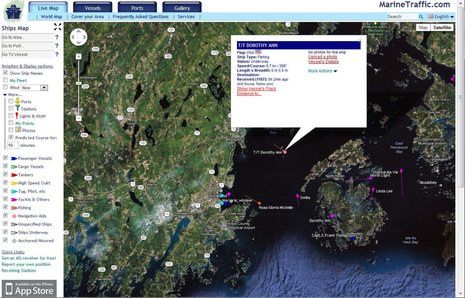
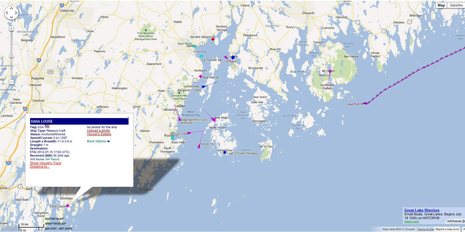
People who like boats are generally wowed the moment they zoom into MarineTraffic’s global tracking map, which includes nearly 50,000 AIS equipped vessels on average, particularly if an area they know is covered by a volunteer listening station. But besides all the real time tracking, MT is a massive database of boat info that can be accessed and added to in all sorts of ways. A simple feature is tracking, which you can get to by first clicking on a target. That’s how I got from the screen at top when I was curious about T/T Dorothy Ann. (Note on that vessel info screen how the “AIS Source” is Panbo.com; in your waters that could easily be the name of your marina or towing operation or whatever, as discussed here).
Note on this screen that my favored viewing setup is “Show Ship Names” with a 10 minute Predicted Course line, but I sometimes change those at different levels of zoom and traffic density. I rarely use the vessel type filters, but they’re useful if, say, you’re trying to find the dozen pleasure boats among the thousands of AIS targets around Hong Kong. At any rate, the track of the tender/to told me a little story about how it and its mother ship had just arrived in the Bay. And while MT has no photos of the T/T (nor its size, though I’d guess it’s big center console tricked out for fishing since someone chose “Fishing” as its vessel type), there are a couple photos of Dorothy Ann…
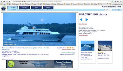
I imagine that this is one of MarineTraffic’s most popular features. AIS has nothing to do with photos, of course, but a boat’s unique MMSI makes them easy to database. And MT generously encourages high resolution uploads and it also protects the photographer’s rights even while letting viewers rate their work and suggest deletions. To continue with the little story — though at risk of sounding like a yacht-spotting snob — I now know that this big yacht is not one I’d go far to ogle. But MT has already tipped me to some boats that I really would like to see in the flesh and it’s going to help me find them thanks to a feature called My Vessel…
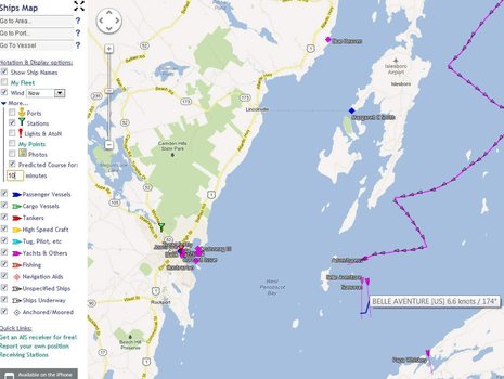
You need to register on MT to use My Fleet and many other services, but it’s free and painless. Then when you are looking at the Vessel Details of a boat you want to keep long term track of — like Wind Horse, which I greeted with email (thanks to MT) as the Dashews made Rockland last night — you just click on “Add to My Fleet”. The benefits are many. If you just check “My Fleet” on tool bar above left, MT leaves realtime tracking mode and zooms in or out to show the last known position of all the boats you’re interested in. This is useful just in terms of navigating around MT maps, but more important is seeing a boat that’s cruised beyond the range of listening stations. Some information about its whereabouts is usually better than none, and My Fleet is easier than using the Vessels/Search All function, though you’ll find recent tracks there too.
Also, once a boat is in your fleet you can enable all sorts of notifications for it. I was tickled to get an MT email Monday night letting me know that the classic yawl Nordwind I wrote about recently was departing Nuuk, Greenland, which I watched on MT’s iPad app. You can see that track yourself from Nordwind’s Itineraries page (at least for a while) and note also that she was last tracked this morning up near Disko Island. (On a per capita basis, Greenland has many more AIS receiving stations that most places but nonetheless Nordwind may not show up on MT for a long time if she really can make it into and through the Northwest Passage.)
As fun as MarineTraffic can be, it used to be that it only showed vessels that have AIS installed and are within reception distance of a volunteer shore station like mine (which varies a lot with both with equipment and weather). But that situation has changed dramatically with the advent of cellular-based “pseudo AIS” apps like MT’s own mAIS and Boat Beacon, which I enthused about in May. I’m even more enthused about them now. Besides myself, I’ve gotten several people to try mAIS (it’s the free one) and it’s worked very well for them. On the screen above you’ll see Panbo reader Brian Strong transmitting the position of his PDQ power cat from Boothbay, for instance (note the AIS Source is “Self Report”). And while I don’t know the crew of CloudDancer — the sailboat going upwest from Downeast — but it’s self reporting too and has been for weeks of what’s looked like a great Maine cruise. Plus my brother-in-law tracked his Grand Banks Brilliant all the way from Cape Cod to here and beyond using both mAIS and a regular Class B, which MT integrated the two sources seamlessly. (Boat Beacon also works fine, doing what mAIS does plus providing its own AIS tracking screens; and the Android version just arrived.)
AIS transmitting via cellular really works, costs virtually nothing, and is a great way to let your friends and family follow your cruising, among other thing. Once understood I think the concept will grow rapidly and will also boost interest in tracking sites like MarineTraffic. For instance, when I “watched” some of the Castine Classic Yacht Race yesterday on MT I was only seeing the boats with real AIS — though they happened to be a trio of amazing Fifes like the just- relaunched Adventuress. But how many of the other boats had at least one Apple or Android phone on board? Yes, it’s very likely that the entire fleet could have been transmitting their positions and also tracking eachother as the day went on. I don’t think this has been done yet in a race or group cruise, but I don’t see why not.
So we’re going to encourage everyone to try mAIS and AIS tracking during the Penobscot Bay Rendezvous which kicks off in two weeks. You may recall that I’m helping to organize the PBR’s powerboat events and will also be participating, so I’ll have good chance to report on this experiment. (YES, there’s still room for more PBR participants, and it’s cool here too: come on up!)
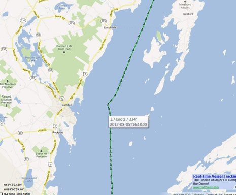
PS 8/6: As Dan points out in the comments there are also uses for MarineTraffic that aren’t in the “fun with AIS” department. I witnessed one yesterday. Well, witnessed in the sense that I was out there in thick fog and could see the 200 meter bulk carrier Nord Peak crawling up the Bay’s shipping lane at 6 knots on AIS and radar. I could also hear the Pilot on board regularly issuing security calls on VHF 16. But apparently a boat crossing the shipping channel east bound decided he had the right of way or didn’t know the Nord Peak was there. At any rate, I’ve never heard a Penobscot Bay Pilot speak so sharply to another vessel and apparently he felt it necessary to put ship “all aback”. No collision took place but it was close, and half the situation is documented on MT’s Nord Peak track record, as partially shown below. The shipping channel does not have a bump in it like that and ships like this never go so slow if they can help it.


Ha! If you look on MarineTraffic.com right now, you’ll see STS Pride Baltimore2 sailing slowly into Penobscot Bay. I haven’t seen her in years but I once got to sail aboard Pride 2 from Astoria, Oregon to San Francisco. The grand finale was an August Saturday noon arrival under full sail (which is a LOT) with a spouting fire boat in attendance. The Pride crew set off cannon broadsides so powerful that they triggered multiple car alarms along the SF waterfront. A very good time indeed.
Pride has 35 photos on MT, which is the most I’ve ever seen and well deserved:
http://www.marinetraffic.com/ais/showallphotos.aspx?mmsi=303302000
This tool is helpful as I document to the corporate owner (Eastwinds Company) that their motor yacht JOANS ARK of Virginia Beach recklessly endangered my sailboat on July 14th on the Connecticut River.
As Marine Traffic picked up the AIS of both boats, I will be able to show JOANS ARK accelerated to 11.4 knots to overtake my 39 foot sailboat BREEZE PLEEZE from astern in a narrow channel before CAN23.
While MT won’t show the captain of the vessel coming abreast to my sailboat and choosing a collision course (we were both pointed at CAN23) that felt like a game of chicken, what I can show using the two Marine Traffic plots for the complaint is documentation to the level of JOANS ARK breaking four USCG regulations in a period of 60 seconds.
MT’s information is pretty good. Maybe not as impressive as a video camera shot that would have show, without referencing broken USCG regulations how outrageously reckless it was to come up behind and pass my sailboat (motoring at the time) at 11.4 knots.
MT also doesn’t give me any evidence of the idiot captain and two other men on JOANS ARK staring back at me in a challenge to get out of their way, that they were certainly not backing down.
MarineTraffic does clearly document JOANS ARK following me as she starts her journey down the CT river. It also shows her accelerating to 11.4 knots at the point before she would pass me. MT’s track for JOANS ARK
http://www.marinetraffic.com/ais/default.aspx?zoom=9&oldmmsi=366913000&olddate=7/14/2012%2012:58:00%20PM
If you compare MarineTraffic’s track for Breeze Pleeze, you can see at a spot JOANS ARK was moving at 11.4 knots, I was moving at 8.8 knots (SOG), about 400 feet before CAN23. (Subtract 1.5 knots to get STW)
http://www.marinetraffic.com/ais/default.aspx?zoom=9&oldmmsi=338042439&olddate=7/14/2012%203:05:00%20PM
The track also shows BREEZE PLEEZE maintained a constant heading and speed for CAN23. I had the mark on my bow. JOANS ARK, overtaking me on my starboard side, would need me to come left into on-coming traffic to have enough room to pass between me and CAN23,
If there was damage or loss of life, MarineTarric would have been sufficient to establish JOANS ARK broke four USCG regulations. Rule 6 (safe speed, moving to fast for the situation), Rule 13 (overtaking), Rule 16 (action by Give-way vessel), Rule 8 (action to avoid collision, specifically pass at a safe distance).
Fortunately only my pride was injured. With the captain of JOANS ARK staring my wife and I right in the eye, my wife demanded I give in, and I spun Breeze Pleeze 180 degrees about to the other side of the channel, and ended the violent battering of our boat by that bully.
Any man hates to be bullied in front of his wife. The ferry size JOANS ARK bullied me on a grand scale in an incredibly stupid and illegal maneuver. Maybe MarineTraffic will help me cause the captain a little grief in return.
Sorry to hear about your incident, Dan. Do collect screenshots as MarineTraffic doesn’t seem to keep track data forever. Also note that there’s a “My Points” feature that would let you put Can 23 on the MT map. Might make the story clearer. By the way, Joan’s Ark was at the Camden Public Landing until very recently.
Ben, using My Points, great idea for illustrating better. I had taken screen shots, but it would be worthwhile to do it over again with CAN 23 marked clearly.
Any chance there is a feature you know of that would combine the tracks from both our boats?
Hi Ben,
I guess this post mainly belongs as a comment to your BoatBecon and mAIS post, but this post is what got me thinking.
I think Internet based position reporting is very cool and sure is attractive as a low cost solution.
Of course sending adding additional information that would not be practical over AIS is also possible.
But at the same time as I relly like it, I think it is abit abusive to call it AIS. This may confuse many into buying something it really is not.
AIS is a complete system transmitting and receiving via VHF, using messages standardized by ITU. It is AUTOMATIC Identification System in the sense that no base station is nescessary for the system to work, unlike a cellular data network.
/J
Good point, Johan, but I think there’s another way to look at it. I believe that what we’re learning is that AIS is really two things. First and foremost, it is the whole system with regulated VHF transponder hardware that we’re familiar with. But it’s also a compact and standardized set of data fields that can describe any boat and what it’s doing uniquely.
Hence AIS records can and are being used for massive databases with all sorts of extras like photos and itineraries tacked on. There’s no reason I know of — except for a possible lack of MMSI numbers, which can be fixed — that the same record format can’t be used with other communications channels. That’s what mAIS and Boat Beacon are about. I don’t know what the eventual name will be — even MarineTraffic seems confused between mAIS and iAIS — but I think it will have an AIS related title and it will become very commonplace.
In fact, I wish a friend had been using mAIS yesterday. We crossed the Bay in fog at almost the same time and my efforts to wait up for him failed as the fog got thicker. He was able to see me via the MarineTraffic app on his iPhone but it would have worked both ways had he also been using mAIS. Or he could have done both at once with Boat Beacon. I did the try the Android version of that and it works fine.
“Fortunately only my pride was injured. With the captain of JOANS ARK staring my wife and I right in the eye, my wife demanded I give in, and I spun Breeze Pleeze 180 degrees about to the other side of the channel, and ended the violent battering of our boat by that bully.
Any man hates to be bullied in front of his wife. The ferry size JOANS ARK bullied me on a grand scale in an incredibly stupid and illegal maneuver. Maybe MarineTraffic will help me cause the captain a little grief in return.”
Regulations as well as common sense also require that even if someone else is in the wrong, you do whatever you can to avoid an unsafe situation/collision. Pride has no business making navigational decisions.
If things were as dangerous as you indicate, the AIS track may also point to (even though it wasn’t true) you not keeping proper watch and your own failure to stand off… it doesn’t mean their actions were right, but it does shift partial responsibility in the case of an accident.
Patrick wrote “What about the MT AIS track suggests “your own failure to stand off””
Ok, I’ll bite.
I thought the only navigation rules related conclusion that could be made on the MT AIS track about Breeze Pleeze was that her course was steady to CAN23 for 2 minutes. That would more than fulfilling requirements as the stand-on Vessel in Rule 17 to hold course and speed.
Rule 17- Action by Stand-on Vessel
(a) (i) Where one of two vessels is to keep out of the way (JOANS ARK), the other (BREEZE PLEEZE) shall keep her course and speed.
(d) This Rule does not relieve the give-way vessel (JOANS ARK) of her obligation to keep out of the way.
Rule 13 – Overtaking
(a) Notwithstanding anything contained in the Rules , any vessel overtaking any other shall keep out of the way of the vessel being overtaken (BREEZE PLEEZE)
Rule 16 – Action by Give-way Vessel
Every vessel which is directed to keep out of the way of another vessel shall, so far as possible, take early and substantial action to keep well clear.
—
There be either a sailboat or a big CAN 23 bonded to JOANS ARK if I held course any longer, so I think I can quote some rules for giving in to the situation 🙂
Very interesting! I just spoke with Penobscot Bay pilot Skip Strong about the incident described in my PS above, and that wasn’t even the worst thing that happened on Sunday. Another PB pilot bringing a tug and barge up the Bay had to “drop the wire” because a sailboat almost got between the tug and tow. Yike!
Skip was very interested to hear about mAIS and thus the possibility of seeing some smaller vessels via an app on a device with a cellular connection. So while I think it’s prudent to think of online AIS and mAIS as mainly for tracking fun, there are definite safety possibilities.
I just returned from a 2 week holiday aboard Hacienda II, my Sabre 34 MKII. We did about 400 miles around Lake Ontario. I’ve had an AIS receiver on board for about 4 years now. It’s been a great tool that’s allowed me to feel a little safer traveling the length of Lake Ontario, especially overnight in and out of the shipping lanes.
After Ben’s article on Boat Beacon, I bought the app and gave it a good work out during the trip. It’s a fantastic app and quite usable on 2 levels:
1. Fun – I sent out an email to friends/family to watch our progress as we overnighted to Kingston. People were emailing me throughout the trip saying that they had been watching our progress and thought it was great that we were able to do that. Comment like “why are you going so slow?” from non-sailors!
2. Safety – It gave us another tool to track other ships. I would check Boat Beacon against our own receiver. Both would show boat traffic in our path but with Boat Beacon, we were able to see them way earlier than our VHF antenna would allow. Also, it usually gave us more information on the ships – name, etc. where for some reason, our receiver only listed the MMSI, Length, Beam, draft, etc.
Drawbacks –
1. Only on the safety side, I did notice that on one day, there were ships missing on the Boat Beacon app that were transmitting AIS. One ship in question didn’t show up on my receiver until we were about 3 miles away so perhaps their transponder wasn’t robust enough to reach the shore station??
2. Power consumption – with Boat Beacon turned on, my iPhone would die very quickly. Need to have it plugged in for sure. Not a big deal but worth mentioning.
Another bit of built in tech from Apple that proved handy was the ‘Find my Friends’ app. I was able to track friends cruising in the area with ease — figure where they were anchored, etc.
Anyway,
Oops hit send a little prematurely…
Anyway, thanks Ben for the tip on that one. Besides safety, its a lot of fun on long passages to have more toys to play with.
I also saw my first sailboat transmitting AIS class B. Nice to see…I kept looking for a ship or CG vessel coming at me. It took me a while to realize it was the sailboat!
Richard
http://www.hacienda2.com
A tug with barge was many miles out heading my way on Long Island Sound. As I was adjusting lines to tack and get well out of the way, I was hailed with a great offer.
Captain contacted me by vessel name (obviously received AIS) offering that I can sail anyway I would like, just tell him, and he would alter course.
How about that. Can’t get those offers when your just an unnamed dot on a radar.
Richard, thanks so much for the thorough Boat Beacon review. I too am at least begining to see real safety possibilities to it. But folks using it have to realize that to see real VHF AIS on Boat Beacon they need to have both a good cell connection AND and a volunteer shore station that is able to pick up all the targets around you. By the way, there are lots of sailboats in New England with Class B AIS now.
Now let’s talk about gadgets. Folks, check out Richard’s hacienda2.com web site to see underway sailing shots and video taken from a radio controlled GoPro camera hanging on a kite. WOW!
But head’s up, Richard, I can’t watch the video here in the U.S. because YouTube says “This video contains content from EMI, who has blocked it in your country on copyright grounds. Sorry about that.” Did you use some background music maybe you shouldn’t have?
Thanks Ben! Interesting about the EMI copyright. Plays fine here in Canada with a link to ‘buy it on iTunes’ (which makes more sense to me) I had some good fun in the 1000 Islands flying the kite off the deck…trying not to decapitate people on jet skis! For those interested, you can check out the kite cam video (should play fine in the US) here: http://vimeo.com/15540859
I’d like to take up Johan’s point, or I think his point. Basically that while “cellular AIS” and mAIS can play a role, the nomenclature may fool some boaters into thinking they really have AIS when they do not, which creates a potentially dangerous situation.
Celluar signal propogation is not a constant and few skippers have their eyes glued to their smart phone or pad to see how many bars are displayed. Worse, the bars displayed tell us very little about who can hear us, thus who can see our position. There is not even an industry standard for what those bars represent, it’s literally at the whim of the cell phone maker (e.g., Apple changed the meaning of the bars on an iPhone last year). The bottom line is that a skipper should not be making any assumptions about what he can see or how well he can be seen, based on cellular AIS. Cellular AIS is a trap for the unsophisticated skipper who thinks he just got AIS for the price of a free download.
Ben, I think you would be doing your beloved AIS, and saftey minded boaters everywhere a service if you led the charge for a different name for cellular AIS. It’s a great service with enormous possibilities, but it’s not AIS and threatens the credibility of “real” AIS.
On a related note, I’m seeing more and more AIS B on recreational cruising yachts (currently in French Polynesia). Four years ago it was only mega-yachts and commercial shipping, today it’s not unusual to see a signal on a 38′ cruising yacht.
I worry that AIS is becoming a ‘phenomenon’and people seem to be scrabbling to do more with it. All SOLAS compliant vessels have to transmit and monitor class ‘A’, reports from authorities such as Solent Port Control say they switch off class ‘B’ as it is overloaded. The British border patrol and navy don’t transmit because they are not SOLAS vessels. I expect to read of a yacht being run down by an aircraft carrier because the yachtsman is relying on AIS.
I presume that AIS SARTs are class ‘A’?, can someone update me on that.
Roger, most of the “scrabbling to do more” with AIS is coming from the very regulators responsible for creating the system and watching over it. Thus we now have AIS SARTs and MoB devices and will eventually have AIS EPIRBs. The phenomenon I notice is recreational boaters worrying about AIS proliferation while the real experts don’t. And incidentally sites like Marine Traffic have no effect on ship-to-ship AIS.
I’d like to see details about switching off Class B in the Solent, but I can tell you a couple of things about what is largely a myth. For one, the MKD display that comes with all Class A transponders is incapable of filtering any targets, period. In fact, it’s illegal in the standard. It is possible to “filter” Class B and other classes of targets off of some bridge displays like ECDIS and radar but usually they are still tracked and will pop up again if they break into CPA/TCPA alarm limits.
On those same displays it’s even possible to completely ignore Class B — which many people confuse with display filtering — but it’s not easy to set up and I don’t believe that it’s often done. It only makes sense in crowded areas where ships have limited maneuverability and therefore can’t do anything about Class B targets anyway and had best focus on Class A vessels.
AIS SARTs are a mix of A and B characteristics. They use messages 1 and 14, which are A, but they broadcast a B-like 2 watts. If you’re concerned that an AIS SART will be missed by a ship filtering B messages, don’t (but the concept is kind of mythical anyway).
As usual with my comments not so many points here, just a few observations:
In my experience is seems that most people involved in getting AIS standardised in the 90s and very early 00s has long left the scene. Retired or moved on to new ventures. The people still involved are very few, and a handful of new people have appeared to get their hands in the cookie jar that the AIS data link has become.
It seems IMO foresaw there may be problems with new AIS type of equiment on the AIS radio link and published this circular:
http://www.imo.org/blast/blastDataHelper.asp?data_id=15510&filename=140%2876%29.pdf
This is not very effective though, and is long overdue to be updated. Maybe is has, anyone here know?
Reading in the IMO webpage I can see the Maritime Safety Committee (MSC) apparently does not approve of free web publishing of AIS data:
http://www.imo.org/ourwork/safety/navigation/pages/ais.aspx
I do not know the reason why, appart from privacy concern of shipping companies.
J, I’m pretty sure that the bureaucratic language in that 2002 PDF is mainly about approving Class B AIS. And the statement about “Administrations should take steps necessary to ensure the integrity of the radio channels used for AIS in their waters” was mainly encouragement for the U.S. to take back control of the AIS frequencies it had leased to a private company (Maritel). That was a bit messy but it was all taken care of so that AIS works on the two standard frequencies everywhere.
And, yes, the IMO did get nervous about the online broadcast of AIS info back in 2004. But I think they dropped their concerns when they realized that bad guys could buy an AIS receiver almost as easily as they could look at an online tracking site, and get more accurate tracking to boot. Or they could subsribe to one of the many commercial AIS tracking services that has better coverage than the free ones do. Essentially it’s been recognized that AIS info is public info.
Hi
Newbie here.
I have 2 computers & on one while I visit marinetraffic.com I see all the ships in all the browsers I use, but, on another computer I do not see any ships although all the boxes are checked to show them and this is using all browsers.
any help will be appreciated.
thanks