
Panbo News and Reviews

AIS, a threat to our liberty? 103
AIS, a threat to our liberty?

Practical_Sailer_Naranjo_AIS_opener.JPG

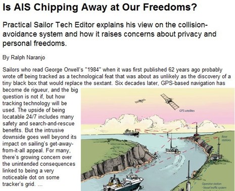
I remember a few years ago when some boaters worried about “Big Brother” style AIS surveillance while the IMO fretted about hobbyists using shore receivers to display real time coastal AIS info on the Web.  But all that seemed to go away, because — I think — people realized that AIS is indeed a public information network and that there is nothing especially threatening about its use by agencies or amateurs.  But today I was struck by a “fatcat1111” comment stating that “I absolutely do not want to update the Fed with my location every 30 seconds” and that he or she hadn’t felt that way until they read the Practical Sailor article above by marine safety expert Ralph Naranjo.  Well, maybe I’m completely blind about “personal freedom” but I’ve read Ralph’s article a few times now, and I just don’t get it…
The LightSquared problem, time to join “Save Our GPS”? 119

The LightSquared problem, time to join “Save Our GPS”?

LightSquared_GPS_jamming_test.JPG

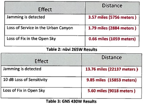
When many readers sent me the GPS World article on GPS jamming, I was blasé.  How could the U.S. government possibly allow LightSquared to put up 4,600 transcievers pumping broadband data services in the L band with such power that they’d significantly interfere with nearby GPS frequencies?  As in complete failure at over half a mile for a high quality civilian GPS receiver like the nüvi 265W, even under an open sky, and almost six miles for a critical GNS 430W aviation unit (as ascertained in lab testing done by Garmin and Trimble, results PDF here).  But then again I never thought our government would be dumb enough to kill the eLoran GPS back-up system just to save a few dollars…
The Solar Stik power tower, & Ganz marine panels 14

The Solar Stik power tower, & Ganz marine panels

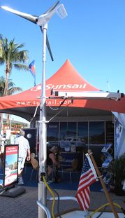
SolarStik_MIBS2011_cPanbo.jpgI was glad to see the Solar Stik back at the Miami Show. I’d been impressed with the engineering — especially that sweet taper — when it was first introduced years ago, and it was nice to learn how many markets the company has found since. I also got a demo (that’s why the photo shows one of the two panels is completely removed, which took seconds), and thus I’m pretty sure that it would be easy to do the turning and tilting required to get the maximum power out the normal panel pair.  I may romanticize the notion of putting one’s rum swizzel down every few hours to tune the solar array while laying in some tropical anchorage, but I don’t think there’s any denying that solar amps are directly related to angle of sunlight (15 degrees in any direction is the key fall-off point, according to the Stik guy).  But would a power tower like this make sense on an amp-thirsty cruiser like Gizmo?

Furuno FM-4000: serious VHF, somewhat new 3

Furuno FM-4000: serious VHF, somewhat new

Furuno_FM-4000_crop.JPG

For those of us who need to be reminded that touch screen isn’t everything, don’t those big dedicated knobs and backlit buttons do the job?  It’s Furuno’s recently introduced FM4000 VHF, which benefits from a good video guide here.   I quip about “somewhat new” in the headline because there are numerous clues — like optional RAM+ mics and Bluetooth headset capabilities — which suggest that the FM4000 is a kissing cousin of Standard Horizon’s GX5500.  There’s nothing wrong with shared expertise, in my view, and knowing it gives a consumer a better idea of what they’re getting into.  Which is a seriously good and easy-to-use radio, I’m pretty sure.

AIS: Global SART detection, ASM info, & a bummer 22

AIS: Global SART detection, ASM info, & a bummer

While exciting things are happening on the frontiers of AIS, there’s still some tragic ignorance about what the technology can do right now for marine safety, even from folks who should know better.  But...

MIBS # 5: C-Map, EarthNC, & MapMedia news 20

MIBS # 5: C-Map, EarthNC, & MapMedia news

Jeppesen_C-Map_charting_app_cPanbo.JPG

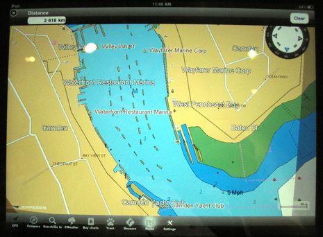
It’s a lousy photo, for sure, but Jeppesen C-Map has not yet announced its iPad charting app, let alone released screen shots, though I found it one of the nicest surprises of the Miami show.  It seems that C-Map not only intends to match Navionics’ much appreciated efforts to offer inexpensive but detailed marine cartography on multiple apps platforms, but to do it even better.  Note, for instance, the “CWeather” button on the menu bar above, and that C-Map has been working to overlay weather data on plotters since at least 2004 (though the then available mechanisms — a complicated cellular connection, or a data card transfer — were awkward).  I’m not sure what CWeather offers today (the Jeppesen site says only European data), but we know that a connected tablet or phone can make the download process very easy.

MIBS #4:  FLIR & PYI Seaview, Furuno & Oceanview 3

MIBS #4: FLIR & PYI Seaview, Furuno & Oceanview

PYI_Seaview_3FL_Pod_cPanbo.jpg

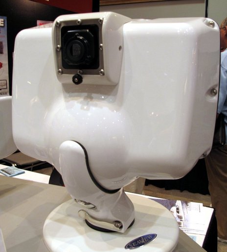
Here’s a clever idea.  PYI worked with FLIR to create an accessory podlet for several of its Seaview MFD pods that serves as an integral casing for a relatively inexpensive (“just over $2,500”) thermal camera core.  The core’s output goes to the video input of whatever MFD is mounted on the working side of the pod so the user then has a simple forward-looking thermal view that can even be aimed using the pan and tilt abilities of the pod.  There’s a major limitation to this idea — the fact that thermal can’t see through glass or plastic — but I can think of situations where it might make a lot of sense…

MIBS #3:  Fugawi, Rose Point, MapTech, & Nobeltec Trident 27

MIBS #3: Fugawi, Rose Point, MapTech, & Nobeltec Trident

Fugawi_ENC_with_Avia_Motor.JPG

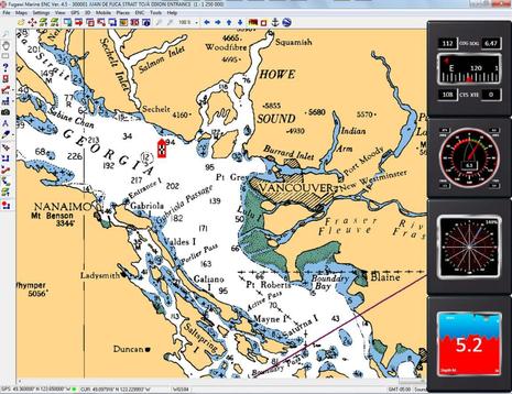
I sense that PC-based navigation is about to enjoy a renaissance after a long period during which rapidly-advancing MFDs stole its thunder.  I can think of several reasons (and you may have more):  Decent performance PCs have gotten less expensive and tougher; NMEA 2000 can feed them more data, more easily (thanks in large part to Actisense); the various mobile platforms so many of us want to fool with on board usually relate well to the less mobile platforms that can also work well on many boats; and, finally, MaxSea and Furuno are showing everyone how powerfully a PC can fit into high-end marine electronics systems.  One company that will participate in this renaissance, I’m pretty sure, is Fugawi…

Chetco SeaSmart.Net modules, wide open N2K-to-Ethernet? 74

Chetco SeaSmart.Net modules, wide open N2K-to-Ethernet?

Chetco_SeaSmart_NMEA_2000_Wifi_Module.JPG

Chetco Digital Instruments has been quietly developing software and hardware to digitize and display analog engine info for some time, and with some success I hear.  But as of yesterday’s big press release, Chetco has jumped big time into marine data networking, particularly the hot, if confusing, area of putting NMEA 2000 messages into an Ethernet format and serving them to whatever wired and wireless devices can use them.  So that little $579 SeaSmart device above contains an N2K-to-Ethernet gateway (by Actisense, I think), a WiFi transciever, and a “CGI/AJAX web server” that puts out an “open sourced HTML protocol” that will purportedly support “any application from weather station, dual engines, battery banks, fluid tanks and more.” Excited yet?…