
Panbo News and Reviews

Raymarine ST-STng converter, hand’s on #1 (GPS) 10
Raymarine ST-STng converter, hand’s on #1 (GPS)

Raymarine_ST-STng_convertor_working_cPanbo.JPG

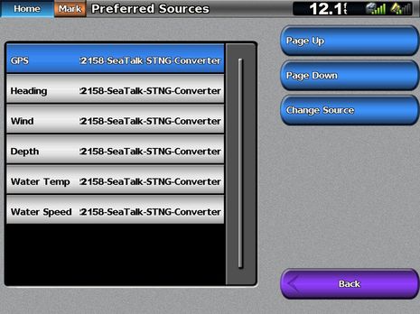
What this screen means:  Since Gizmo’s current NMEA 2000 network has more than one sensor able to supply the types of data listed above, the Garmin 5212 gives me a choice of which source to use, and in each case I’ve chosen data that originated from Raymarine SeaTalk sensors and instrument displays, but was converted to SeaTalkNG (aka NMEA 2000) by Ray’s much-discussed-on-Panbo ST-to-STng Converter.  Not only does the Garmin perceive all that converted SeaTalk data as valid NMEA 2000 PGNs, but it all looks decent when displayed, and I’ve done similarly successful testing on the Simrad NSE, Lowrance HDS, and Furuno NN3D MFD.  So, despite Ray’s caution against using the converter on a standard N2K backbone, a whole passel of ST40 instruments are feeding Gizmo’s network, and getting power off it.  And maybe that’s all you need to know, though I did get into some nitty gritty detail…

Adventure Zone, & more Spot Hug details 19

Adventure Zone, & more Spot Hug details

Trackme360_Adventure_Zone_NARC_2010.JPG

Though already a fan of SPOT for reasonably easy and inexpensive boat tracking, I didn’t realize until yesterday that there is a slick way to track whole fleets of Spot-equipped vessels (or back country runners, dog sleds, whatever), even with photos and commentary on the same site.  Go to the Adventure Zone and select the NARC Rally for a current example.  I’m not sure, but the service — provided by TrackMe360, which rents Spots, among other things — may even be free.  And note how spread out and “off course” the NARC fleet (more info here) is, due to the atrocious weather that’s plagued the Northeast lately.  One thing I’m more sure of is that boats like these will find Spot services easier to use once they can install Hug systems, instead of using handhelds…

Moonraker makeover, by Electronics Unlimited 7

Moonraker makeover, by Electronics Unlimited

Moonraker_helm_courtesy_Electronics_Unlimited.JPG

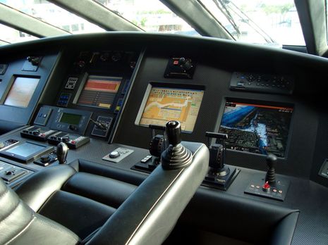
While at FLIBS, I had the pleasure of meeting Mike Spyros, Director of Service & Technical Development for Electronics Unlimited.  Per usual, I invited Mike to send in details of a notable install (an open invitation, incidentally), and by golly he did, and she’s a corker.  The 116-foot M/Y Moonraker might have been built in 1992, but is still claimed to be the world’s fastest mega-yacht, with a cruise speed of 28 knots. And I think the electronics makeover Mike and his team did last year is an interesting example of how familiar smaller boat brands and NMEA 2000 can be used to manage even a giant jetski…

Furuno WS200 detail; you’ll laugh, you’ll cry… 40

Furuno WS200 detail; you’ll laugh, you’ll cry…

Furuno_WS200.JPG

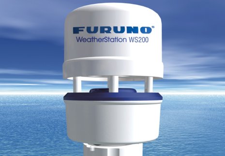
Furuno’s new WS200 wind/heading/GPS etc. sensor is obviously a re-branded Airmar PB200, and that’s fine; some customers want all their electronics to come from one manufacturer (and sometimes I think they’re smarter than I am ;-).  But, in fact, there is one slight difference between the WS200 and the PB200 that Airmar ships today, and once you understand it, and the silliness around it, you too may laugh, cry, scream, or some combination thereof…

Nobeltec VNS & Admiral 11, the preview 5

Nobeltec VNS & Admiral 11, the preview

Nobeltec_NavView_Fuel.JPG

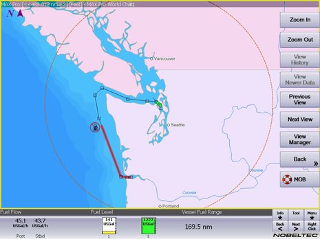
Real time fuel range — as when it’s calculated using actual fuel flow and tank levels — is darn useful information; for instance, it should let you instantly see the effects of RPM or sea state changes not only on your MPG but also on your ability to get somewhere without a forced stop.  Which is why it’s neat that the Nobeltec 11 preview screen above shows the value as a number, as a circumference from your present position, and even as a distance along your active route.  And there’s an implication to this screen that I’m sure many of you will welcome (and may have already figured out)…

CoolSaver, really smart fridge control? 18

CoolSaver, really smart fridge control?

CoolSaver_reference_guide_clip.JPG

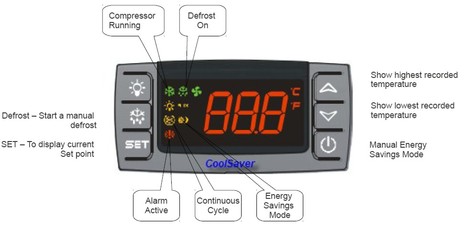
The final product photography isn’t finished yet, but there’s certainly enough info up at CoolSaver.net to discuss this interesting advance in refrigeration control for power-conscious cruisers.  What seems unique is a feature called Charge Sense, which can push fridge temps down to a user set low when there’s excess power available from an alternator, generator, or solar array, and conversely minimize power use when it’s scarce. Which, if it works well, could be a pretty big deal on a lot of boats, including my own Gizmo…

More on iPad as extra nav screen, from Nobeltec 11

More on iPad as extra nav screen, from Nobeltec

Nobeltec_Admiral_on_iPad_courtesy_Nobeltec.JPG

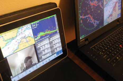
It’s not just the new edition of Coastal Explorer that can play nicely with an iPad.  In fact, it turns out that anyone running Nobeltec Admiral v6.5 or higher can get their iPad to show a variety of independent screens like the one above.  That’s because Admiral has long supported the extended desktop capabilities of Windows, as well as touch screens.  But Nobeltec Product Manager Bill Washburn, glimpsed in his own camera above, warns that screen refresh rate is marginal, at least at this point…

Jonesport breakwater aid, with ChartAid 16

Jonesport breakwater aid, with ChartAid

Jonesport_breakwater.JPG

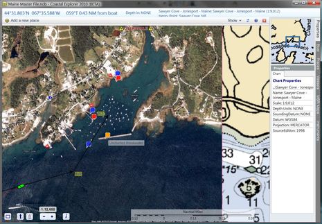
An interesting solution for the Jonesport uncharted breakwater problem came all the way from the S/V True Love in La Paz, Mexico.  Skipper Bill Stockton has written a program called ChartAid which can turn Google Earth photo maps into BSB format so you can navigate on them in programs like CE, Nobeltec, and Chart View.  I did get an “Invalid BSB” warning when I installed the chart Bill sent into CE, but it works fine.  As you can see above, the registration with the official chart looks spot on, and my vessel, track, and route, plus data sets like GuideBook, overlay properly.  Even the “properties” make sense, with the possible exception of the Source date.  And apparently it’s easy to make such photo maps with ChartAid…

Simrad StructureScan, learning the tool 8

Simrad StructureScan, learning the tool

Simrad_StructureScan_thorofare_cPanbo.JPG

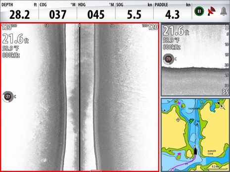
Rats!  I thought I’d recount some of the summer’s Simrad StructureScan experience since I mentioned it in Monday’s entry about chart problems, and while I was pleased to find a screenshot taken right in the Thorofare discussed…I failed to snap one after passing over the disputed danger.  But you can see how flat and smooth the bottom is just short of what is supposed to an “awash (at low tide) rock”; please trust that the bottom stayed just like that as I drove right over the annoyance, as I posted on AC.  But maybe you can’t intrepret the screen above well until you see more of what this side looking technology can do…

Why we need crowd sourcing, Downeast #2 25

Why we need crowd sourcing, Downeast #2

uncharted_Jonesport_breakwater_cPanbo.JPG

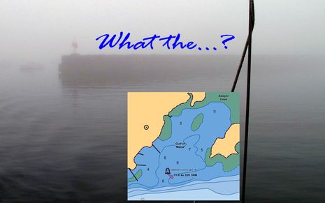
Yup, the first time you cruise into Sawyer Cove in often foggy Jonesport, Maine, you may be surprised to discover that there is a substantial steel and concrete breakwater extending from the fixed light almost all the way to the Eastern shore.  That’s because the structure still hasn’t made it onto the official charts, or any chart I’ve seen, even though it was built over 20 years ago, and even though the NOAA ENC inset above was updated on 9/17/2010.  I mentioned this when I first wrote about Sawyer Cove in August, but that entry was largely about how poorly any of the guides — digital or paper, professionally written or crowd sourced — covered the facilities available.  Since then I’ve learned more about the breakwater situation, and it’s depressing…