Category: Handheld

New iThing charting apps, EarthNC & eSeaChart 31

New iThing charting apps, EarthNC & eSeaChart

EarthNC_iPhone_1_cPanbo.JPG

Not one but two iPhone NOAA raster charting apps debuted last week, and I had had a little Beta time with each.  EarthNC for iPhone costs $25 and incorporates some fresh thinking and a lot of the resources EarthNC has long been developing for its Google Map & Earth overlay products, like EarthNC Online.  They’ve turned all NOAA RNCs into tiles that download automatically to your phone as you pan and zoom, or you can batch download an area as illustrated in the screen at upper right.  The left screen is busy looking, I know, but note how you can disappear each of those data and icon strips with the little red arrow.  Note too how EarthNC is doing waypoint navigation and tracking, fairly elaborate tracking as shown on the middle screen.  But that’s not all…

SiMON2, for iPad & “smaller” yachts 12

SiMON2, for iPad & “smaller” yachts

SiMON2_engine_screen.jpg

The press release calls SiMON2 “the first alarm monitoring system for the new Apple iPad,” which seems odd given what we’ve already seen from InteliSea.  I think what Palladium Technologies was trying to say is that SiMON2 is the first such app designed exclusively for the iPad.  It is not just an extension of a full bore PC-based megayacht system, like iSiMON or InteliSea, but rather a new iPad-centered monitoring system designed for “smaller” yachts…

Maturing iPhone apps, troubled ENC edition 18

Maturing iPhone apps, troubled ENC edition

Charts_Tides_iPhone_AC_cPanbo.JPG

Pardon me if I use an entry on the improving state of marine iPhone apps to illustrate my concerns about NOAA’s local chart screw ups, but it works.  Navimatics Charts&Tides 3.6.2 was the first charting program of any sort I’ve seen that includes NOAA’s first 1:20,000 ENC for Camden Harbor, but it will be confusing fog bound visitors soon!  Those semi-invented channel buoys that I first saw on the raster chart are worse here, given equal graphic weight with real navigation aids, more precise looking wrong locations, and all without the “Priv aids” label that might help a navigator sort things out…

Tracking every which way, & Gizmo blows a gasket 4

Tracking every which way, & Gizmo blows a gasket

Paloma_first_boat_ride_Android_tracking_cPanbo.JPG

Yeah, yeah, yeah; the new iPhone 4 was announced and it looks pretty cool.  And if its GPS and background apps processing are good enough, maybe it can track as well as my Droid Incredible ;-).  That track above especially exemplifies the value of easy tracking as it documents my five-month-old granddaughter’s first boat ride, a row around Camden Harbor in search of my bird buddies.  Though I simply fired up Google My Tracks and stuck the phone back in my pocket, the accuracy is excellent, even in my truck as I drove home, as you can see here in a Google My Map (which I was able to create from the phone with a couple of clicks).  That’s why My Tracks is a favorite at the moment, though I have so many tracking options my head spins, and sometimes the memories captured are a lot less pleasant…

iNavX on the iPad, a Beta tester’s enthusiasm 23

iNavX on the iPad, a Beta tester’s enthusiasm

iNavX_on_iPad_courtesy_Tom_MacNeil.JPG

Navigation on iPad is a hot subject, as discussed here recently (and, mind you, Navionics has now joined the iPad possibilities).  So I’m pleased to publish the following excerpt from a review by Tom MacNeil, a long time beta tester for the GPSNavX/ MacENC/iNavX family of charting programs.  To say that he’s enthusiastic about how developer Rich Ray’s software runs on an iPad is an understatement!  Tom has been sailing and messing with boat technology for thirty years, and currently runs an marine electronics and electrical shop somewhere in the Pacific Northwest.  Warning:  If you read the following, you may soon find yourself at the Apple Store typing in your credit card number…

Verizon Droid Incredible, indeed it is 24

Verizon Droid Incredible, indeed it is

Verizon_Incredible_and_iPhone_3GS_do_GPS_cPanbo.JPG

While it’s been disappointing to learn that carrying around two smart phones does not make a guy extra smart, I am incredibly happy about owning that Verizon Droid Incredible at left.  It’s not a phone I’d recommend to everyone — and Android marine apps certainly aren’t much yet — but given what I want from it, and where I live, the Incredible makes that iPhone 3GS seem feeble and limited.  I feel like I just got out of Apple/AT&T jail, and I’m shaking my head because I liked it in there!  Let’s begin with the built-in GPS and motion sensors…

The damn iPad: iNavX, X-Traverse, Navimatics & AC 57

The damn iPad: iNavX, X-Traverse, Navimatics & AC

iNavX_iPad___iPhone.JPG

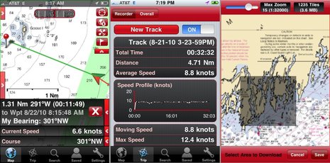
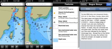
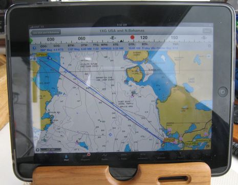
It’s so sad:  Nowadays when I contemplate my amazing portfolio of iPhone marine apps (discussed here, here, here, and elsewhere) in iTunes, featured right across the top of my PC screen are the ones now also optimized for the iPad.  But I don’t have an iPad (though I did touch one).  And behold the difference.  The size of what you see when you click on the image above will depend on your particular screen’s pixels-per-inch resolution, but the proportions are right regardless.  iNavX on a 9.7-inch, 1024 x 748 pixel iPad is obviously quite different from iNavX on a 3.5-inch, 320 x 480 pixel iPhone.  There’s room for more chart and bigger touch buttons, not to mention nav data and a compass ribbon across the top.  Damn…

Inmarsat, Iridium, & Globalstar…the horse race 15

Inmarsat, Iridium, & Globalstar…the horse race

inmarsat_isatphone-pro_collage.JPG

Competitive heat is really building in the portable global sat phone/messenger sector, and once it gets sorted, it’s got to be good news for those of us who venture beyond cellular networks.  Last week Iridium announced that its smaller, cheaper 9602 SBD modem is ready ahead of schedule to some 90 “integration partners,” and a few weeks before that Inmarsat detailed its IsatPhone Pro (due in June), including its game changing pricing.  And while I discussed both of these developments here in January, it’s Globalstar that may be the dark horse in this race…

Garmin visit #2, GPSMap 78 6

Garmin visit #2, GPSMap 78

Garmin_78_industrial_design_evolution_cPanbo.JPG

Today Garmin introduced the GPSMap 78 series, an apparently major refresh of the 76 series long popular with boaters.  While I only got to fiddle with a pre-production unit for a moment, I did learn a lot about the industrial design process behind it.  The ID department in Olathe — aka “The Skunk Works” or “Area 51” —  has a tool collection that would make all sorts of craftsmen and artists drool, but I’ll save that story for another day.  What’s particularly notable about the exhibit shown above and below is how many design iterations were created and modeled for the 78, and how detailed they were…