Panbo News and Reviews

Onboard WiFi hotspot, Rogue Wave & WirieAP 61

Onboard WiFi hotspot, Rogue Wave & WirieAP

Rogue_Wave_vs_TheWirieAP_cPanbo.jpg

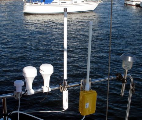
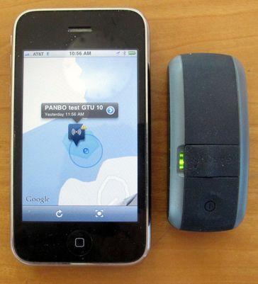
Perhaps the main thing I learned while testing the Rogue Wave and the WireAP this summer is that I love having a private WiFi hotspot on Gizmo. The Rogue is Ethernet cabled to Land & Sea’s refurbished Netgear router and both are wired to a 12v fuse block, while of course the WireAP simply has a single 12v feed because both its high power WiFi client and access point are in that yellow waterproof case. So in either case I can step aboard, flip one switch and if the last shore hotspot used is still available then everything that can be online via Wifi — Datalux nav computer, Mac Mini, iPad, iPhone, Android Incredible, or even the Vizio TV — is online whenever it’s powered up…

Iridium Force: 9575 Extreme, AxcessPoint, & the 9523 Core 24

Iridium Force: 9575 Extreme, AxcessPoint, & the 9523 Core

Iridium_9575_Extreme_sat_phone.jpg

“Iridium Force” — announced today with much fanfare — seems to be an entire “vision for the future of personal mobile satellite communications”, a bunch of new hard- and software products, and what may be a heck of a business strategy. You can read the press release or sign onto a whole Iridium site full of videos and more, but just the hardware tells a lot of the story. The new Iridium 9575 Extreme handset seen above is not just a highly ruggedized version of Iridium’s most recent 9555 sat phone; it includes an internal GPS, a dedicated SOS button, and it seems capable of doing most everything that devices based on Iridium’s 9602 SBD modem can do, like, say, the DeLorme inReach and the YellowBrick3 that are both due to ship soon…

B&G Triton, all-in-one N2K instrument & pilot keypad 36

B&G Triton, all-in-one N2K instrument & pilot keypad

B_G_Triton_NMEA_2000_instrument.jpg

When I hinted last week that the new Raymarine i70 all-in-one NMEA 2000 instrument would soon have a new competitor, I honestly didn’t realize that the B&G Triton would be announced today (with at least the Australian release online already). The Triton T41 sports a 4.1-inch color display under a 4.6-inch square bezel while the i70 has a 4-inch screen in a 4.53-inch high by 4.3-inch wide case. And I’ll bet the Triton is also LED backlit as it too claims wide viewing angles along with a power range of just 50-150 milliamps, which seems similar to Ray’s claimed 135ma “typical” usage. You’d almost think that Navico and Raymarine were looking over each other’s shoulders!…

Raymarine i70, new king of all-in-ones? 6

Raymarine i70, new king of all-in-ones?

Raymarine_i70.jpg

With all the fuss about Raymarine’s new e7 MFD, the similarly styled i70 all-in-one instrument may not have gotten the attention it deserves. That 4-inch LED-backlit screen is a nice half inch bigger than the ST70, not to mention the very successful Garmin GMI 10, and it looks like the software designers made maximum use of the display space. If you’re going to mimic an analog dial on a rectangular screen, that flattened style above makes sense. (And note the dots showing minimum, maximum, and average wind angles, a graphic nicity that I liked on the original ST70 but still haven’t seen elsewhere.) You can find out more about the i70, and the new p70 autopilot heads, at this Raymarine page, but I came across a dealer presentation that has some extra details…

Garmin GTU 10, a remote anchor watch? 10

Garmin GTU 10, a remote anchor watch?

Garmin_GTU10_Irene_anchor_watch.jpg

I’m pretty impressed with the Garmin GTU10 I’ve been testing this summer. Inside that little IPx7 waterproof case is a sensitive GPS, a GSM cell modem, and a fairly able lithium ion battery. For $200 you get the hardware, a cute case (meant primarily for hanging on a dog collar), and a one year standard data subscription which normally costs $50. The subscription doesn’t get you much in terms of remote tracking — just the last ten points, whose spacing will vary with settings — but you do get unlimited notifications about when the GTU 10 enters and/or leaves up to 10 geofence areas that you can define at mygarmin.com, or with the free Android and iOS Garmin Tracker apps. And aren’t geofences the key to knowing that your boat or tender are where they’re supposed to be, especially when anchored?…

Hurricane Irene, the long anchor watch #1 11

Hurricane Irene, the long anchor watch #1

So it’s Sunday morning and the early signs of Irene are here in the form of 100% humidity and easterlies in the high teens. That wonderfully large Fortress 55 anchor seen above in my tender yesterday afternoon is set about 150 feet to weather in 20-30 feet of water and Gizmo’s regular hook, a Kingston K-45, is about the same distance to the southwest. The best part, though, is that I’m snugged into Pulpit Harbor where it’s quite unlikely that I’ll experience any significant wave action. In my experience it’s that action and the resulting line chafe that usually causes boats to go ashore in conditions like we’re expecting. You can see Gizmo’s position on this Spot share map, and I’m also using this situation to try out a number of other electronics…

Maretron FFM100, positive displacement fuel flow metering 13

Maretron FFM100, positive displacement fuel flow metering

Gizmo_NMpG_graph_cPanbo.jpg

As illustrated above, the fuel cost for cruising Gizmo varies enormously with speed. It’s fortunate that we like poking along at 6 to 8 knots in most conditions because knocking off miles on a 16-17 knot semi-plane is 4-5 times more expensive. But as suggested by the lumpy lines, those fuel-flow versus boat-speed numbers are not necessarily precise, and since I was only able to collect them on one day, they definitely don’t reflect changes in vessel trim, bottom cleanliness, engine condition, etc. I’d love to have accurate real time fuel flow data flowing around Gizmo’s NMEA 2000 network and thus am excited about Maretron’s FFM100 system, which was recently introduced with bold claims…

Navionics Mobile 2, with NewStand & more 12

Navionics Mobile 2, with NewStand & more

Navionics_Mobile_2_Newstand_cPanbo.jpg

Months ago I heard that Navionics was planning to add boating magazine content to its mobile charting apps, but I didn’t know until the new 2.0 version came out that “my” Bonnier Marine Group was a lead participant! The implementation is pretty slick too. As long as your iPad or iPhone is online you can browse the “NewsStand” for cruising pieces relevant to your location or for articles listed by various subject categories or even ranked by reviews from fellow Navionics Mobile users. And you can download and read them two ways…

Racing capsizes, did satellite beacons help? 9

Racing capsizes, did satellite beacons help?

Rambler_100_capsized_courtesy_Phaedo.jpg

Man, can you imagine how many scary moments preceded this photo? The remarkable thing is that all 21 crew members of Rambler 100 survived her capsize in rough and foggy conditions just after rounding Fastnet Rock on Monday evening. The yacht — which I gawked at as Speedboat in Newport last fall — purportedly turned turtle just 30 seconds after her keel snapped off, leaving several crew caught inside and upside down. EPIRBs and PLBs had something to do with the 100% successful rescue, though it’s hard tell which and how…

Automated VHF radio checks, Sea Tow & USCG 25

Automated VHF radio checks, Sea Tow & USCG

Sea_Tow_ARC_service_map_August_2011.jpg

Sea Tow recently announced that all its franchises have now installed an automated radio check (ARC) service, and it seems very easy to use. Just check out Sea Tow’s ARC page for the active channel in your area — usually the old Marine Operator channel still managed by its communications partner Maritel — and make a call. If you’re in range you should hear an automated response telling you the location of the receiving base station followed by a recording of your call so you can confirm beyond doubt that your VHF is transmitting. Unfortunately I can’t try the system myself, as the active service map above correctly indicates that ARC doesn’t quite reach Penobscot Bay yet, but I’m hoping that readers who boat in active (yellow) areas will report about how it works…